
Podhradí u Aše
| Podhradí | |||||
|---|---|---|---|---|---|
|
|||||
| Basic data | |||||
| State : |
|
||||
| Region : | Karlovarský kraj | ||||
| District : | Cheb | ||||
| Area : | 636,4063 ha | ||||
| Geographic location : | 50 ° 15 ′ N , 12 ° 12 ′ E | ||||
| Height: | 562 m nm | ||||
| Residents : | 197 (Jan. 1, 2019) | ||||
| Postal code : | 351 23 | ||||
| License plate : | K (old CH) | ||||
| traffic | |||||
| Railway connection: | Aš – Adorf | ||||
| structure | |||||
| Status: | local community | ||||
| Districts: | 1 | ||||
| administration | |||||
| Mayor : | Kamila Volková (as of 2018) | ||||
| Address: | Podhradí 55 352 01 Aš 1 |
||||
| Municipality number: | 538817 | ||||
| Website : | www.oupodhradi.cz | ||||
| Location of Podhradí in the Cheb district | |||||

|
|||||


Podhradí ( German Neuberg ) is a municipality in Karlovarský kraj in the Czech Republic .
geography
Geographical location
Podhradí is located three kilometers north of the city of Aš in the Bohemian Vogtland and belongs to the Okres Cheb . The location extends in the valley of the stream Ašský potok in the Elster Mountains and is dominated by the 22 meter high keep of the Neuberg castle ruins . Neighboring towns are Kopaniny in the east, Dolní Paseky and Aš in the south and Kamenná , Marak and Smrčina in the west. The Studánecký vrch ( Hungersberg , 696 meters high) rises in the north, the Vyhlídka ( Leitenberg , 678 meters high) in the southeast on the German border and the Háj ( Hainberg , 757 meters high) with the Bismarck Tower in the south .
Neighboring places
| Hranice (Rossbach) | ||
| Krásná (Schönbach near Asch) |
.svg)
|
Aš (ash) |
| Aš (ash) |
history
The village of Neuberg was founded in the 12th century at the foot of the castle of the same name. The first written record dates back to 1288. owner of the manorial system was at the time the sex of the Knights of Neipperg . In 1394, after the death of Konrad von Neuberg, ownership of this line fell to the Neippergers, who last called themselves von Neuberg, to the Zedtwitzer family . During the Reformation, the place became Protestant along with the area around the Ascher Zipfel . The castle was devastated during the Thirty Years' War. In 1690 the Sorg Castle was built; In 1693 the Neuschloß Castle was built. The castle was built below the castle. After the rulership was divided, the Lower Part Castle was built in 1750 and the Upper Part Castle was built in 1752. The remains of the castle were used as building material for this construction.
In 1885 the Neuberg stop was built near Elfhausen on the newly built Asch - Roßbach local railway . During the Habsburg Monarchy, the community belonged to the judicial district of Asch or District Asch .
In 1902 the upper part of the castle burned out and was no longer rebuilt. The lower part of the castle ( Dolní zámek ), which fell into disrepair after the Second World War , was demolished in 1965; an investigation and documentation of the building had not previously been carried out. All that remains is the inaccessible old tower of the castle.
After the Munich Agreement , Neuberg was added to the German Empire and belonged to the Asch district until 1945 .
The settlements Neuschloß, Sorg , Steinpöhl and Elfhausen also belonged to the place . The Zedtwitz were expropriated in 1945 after 550 years of ownership in Neuberg.
In 1946 the German residents were expelled .
Population development
|
|
|
Culture and sights
- The Church of the Good Shepherd was built between 1470 and 1490 by the Eger burgrave Heinz von Zedtwitz as a castle and burial chapel. In 1542 the church became Protestant; it is said to be the oldest Protestant church on the territory of the Austro-Hungarian state, which existed until 1918 . Between 1678 and 1682, under Ernst Wolf von Zedtwitz, it was converted into a baroque church. In 1992, conservation measures were started, for which former German residents made a large part of the funds available. A service in German was held every second Sunday of the month. In addition, since 1992, a parish fair has been celebrated on the second Sunday after Easter.
- Educational trail on local history
- Penitential cross , am Kirchberg on 1 February 1290 by Heinrich von Plauen built
- War memorial for the victims of the Kossuth uprising of 1848/49, the Battle of Solferino and that of Königgrätz
- Neuberk Castle
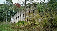
- Former Smrčina Castle ( Sorg Castle ), the building built for Karl Joseph von Zedtwitz in 1690 was owned by the family until 1911 and then had to be sold to the Ascher entrepreneur Wilhelm Fischer due to over-indebtedness. After 1945 the castle deteriorated, in 1963 it was demolished due to the risk of collapse. Only the dilapidated farm buildings have been preserved ; today there is a silage pit on the site of the castle .
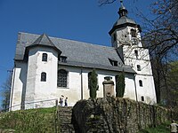
Church of the Good Shepherd

Upper part of the epitaph painting of Anna Dorothea von Zedtwitz , b. Reitzenstein in the Neuberg Church
Ruins of the Upper Part Castle, which burned down in 1902

Remains of the castle in Neuberg (2012)


Personalities
- Ernestine von Fricken (1816–1844), pianist
- Leopold Chalupa (* 1927), General a. D. and former Commander-in-Chief of the NATO Armed Forces Central Europe. He is an honorary citizen of his place of birth.
literature
- Guntram Dunger (Ed.): Bad Elster and surroundings . Bad Elster 2002. p. 67f.
- Magdalena Šmrhová: Asch and its surroundings in old views . Hostivice 2011. ISBN 978-80-86914-34-3 . P. 200ff.
Individual evidence
- ↑ http://www.uir.cz/obec/538817/Podhradi
- ↑ Český statistický úřad - The population of the Czech municipalities as of January 1, 2019 (PDF; 7.4 MiB)
- ↑ Historický lexikon obcí České republiky - 1869-2015. Český statistický úřad, December 18, 2015, accessed on February 11, 2016 (Czech).