
Kopaniny (Aš)
| Kopaniny | |||||
|---|---|---|---|---|---|
|
|||||
| Basic data | |||||
| State : |
|
||||
| Region : | Karlovarský kraj | ||||
| District : | Cheb | ||||
| Municipality : | Aš | ||||
| Area : | 354 ha | ||||
| Geographic location : | 50 ° 16 ' N , 12 ° 14' E | ||||
| Height: | 540 m nm | ||||
| Residents : | 122 (2011) | ||||
| Postal code : | 352 01 | ||||
| License plate : | K | ||||
| traffic | |||||
| Street: | Aš - Bad Elster | ||||


Kopaniny ( German Krugsreuth ) is a district of the city of Aš in the Czech Republic .
geography
Geographical location
Kopaniny is located two kilometers south of Bad Elster on the border with Germany in the Okres Cheb . The location is on the left above the valley of the White Elster in the Elster Mountains . To the north rise the Kopaninský vrch (645 m) and the Wolfsberg (596 m), in the northeast the Reuther Höhe (602 m), east the Strážný (628 m) and the Plattenberg (683 m), in the southeast the Vyhlídka (678 m) ), south of the Háj (757 m) and in the northwest of the Studánecký vrch (Hungersberg, 696 m).
Neighboring communities
Neighboring towns are Kessel and Bad Elster in the north, Reuth in the northeast, Doubrava in the east, Gürth in the southeast, Dolní Paseky in the south, Podhradí in the southwest and Novoměstí and Studánka in the northwest.
history
The village probably originated in the 12th century. The place was first mentioned in writing in 1315. The owners were the von Feilitzsch on Sachsgrün, von Neipperg and finally the von Zedtwitz family on Neuberg . A knight seat of the Lords of Zedtwitz has been documented in Krugsreuth since 1537. After the division of the Neuberg estates, Krugsreuth was subordinate to the upper part from the middle of the 18th century.
After the abolition of patrimonial Krugsreuth formed a community in the Asch district. The place was divided into the locations Unterdorf, Mitteldorf and Juchhöh. In 1930 the workers gymnastics club built an outdoor swimming pool that became known as the Red Sea. In 1939 the village had 868 inhabitants. After the Munich Agreement, the village fell to the German Empire and belonged to the Asch district between 1938 and 1945 . After the end of the Second World War, Kopaniny came back to Czechoslovakia in 1945. The German population was expelled in 1946 ; Because of its remote location near the closed border to the Soviet occupation zone, the village could only be sparsely repopulated. In 1947 Kopaniny only had 297 inhabitants. At that time the swimming pool was also given up. The population decline continued. In the 2001 census, 94 people lived in the 51 houses in the village.
Population development
|
|
|
Culture and sights
- Kopaniny Castle , built in 1612 for Bartholomäus von Zedtwitz. It was expanded in the years 1677–1678. In 1945 Franz von Zedtwitz was expropriated. The castle was looted, ruined and left to decay. It has been restored since 2013.
- Herz-Jesu-Kirche; the single-nave neo-Gothic building was built in 1890 on the Catholic cemetery. In October 1990 the church was robbed. In the 1990s, the church was repaired with the help of former residents.
- Former Catholic cemetery with family crypt on the Zedtwitz-Neuberg Obteil line, the cemetery was established in 1890
- Former Protestant cemetery, laid out in 1889

Town View (2008)
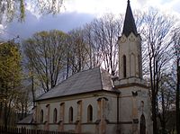
Herz-Jesu-Kirche (2008)

Castle ruins (2008)
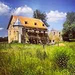
Restoration of the Kopaniny castle ruins (2013)


literature
- Magdalena Šmrhová: Asch and its surroundings in old views . Hosivice 2011. ISBN 978-80-86914-34-3 . P. 177ff.
Web links
Individual evidence
- ↑ a b Historický lexikon obcí České republiky - 1869-2015. Český statistický úřad, December 18, 2015, accessed on February 5, 2016 (Czech).

Aš | Dolní Paseky | Doubrava | Horní Paseky | Kopaniny | Mokřiny | Nebesa | Nový Žďár | Vernéřov