
Křižovatka
| Křižovatka | |||||
|---|---|---|---|---|---|
|
|||||
| Basic data | |||||
| State : |
|
||||
| Region : | Karlovarský kraj | ||||
| District : | Cheb | ||||
| Area : | 1412.7646 ha | ||||
| Geographic location : | 50 ° 12 ' N , 12 ° 24' E | ||||
| Height: | 473 m nm | ||||
| Residents : | 274 (Jan. 1, 2019) | ||||
| Postal code : | 351 34 | ||||
| License plate : | K (old CH) | ||||
| structure | |||||
| Status: | local community | ||||
| Districts: | 2 | ||||
| administration | |||||
| Mayor : | Jan Strachota (as of 2018) | ||||
| Address: | Křižovatka 103 351 34 Skalná |
||||
| Municipality number: | 554596 | ||||
| Website : | www.kr-karlovarsky.cz/obce/Krizovatka | ||||
| Location of Křižovatka in the Cheb district | |||||

|
|||||


Křižovatka ( German Klinghart ) is a municipality in Karlovarský kraj in the Czech Republic .
geography
Geographical location
It is located on the southeast slope of the Elster Mountains and belongs to the Okres Cheb .
Community structure
The municipality Křižovatka consists of the districts Křižovatka ( Klinghart ) and Nová Ves ( Neudorf ). Basic settlement units are Křižovatka, Mostek ( Bruck ) and Nová Ves.
The municipality is divided into the cadastral districts of Křižovatka, Mostek u Křižovatky and Nová Ves u Křižovatky.
Neighboring places
| Velký Luh (Großloh) | Plesná (Fleißen) | |
| Skalná (Wildstein) |
.svg)
|
Nový Kostel (Neukirchen) |
| Třebeň (Trebendorf) | Milhostov (mill meal) |
history
The origin of the place goes back to the year 1199. The first written mention was made in 1322. Around 1213 the first church was built, which was one of the oldest in the region. It was destroyed many times, for example after the Hussite Wars in 1446 and after the Thirty Years' War . The population lived primarily from agriculture, but from the beginning of the 20th century also from the manufacture of textile products and the construction of musical instruments. From the middle of the 19th century, the place belonged to the judicial district Wildstein and district Eger .
After the Munich Agreement , the place was added to the German Empire and belonged to the district of Eger until 1945 .
Development of the population
|
|
|
Culture and sights
Buildings
- Church of Saint Catherine
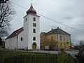
renovated Křižovatka Church
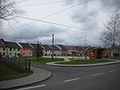
Center of Křižovatka


Individual evidence
- ↑ http://www.uir.cz/obec/554596/Krizovatka
- ↑ Český statistický úřad - The population of the Czech municipalities as of January 1, 2019 (PDF; 7.4 MiB)
- ↑ http://www.uir.cz/casti-obce-obec/554596/Obec-Krizovatka
- ↑ http://www.uir.cz/zsj-obec/554596/Obec-Krizovatka
- ↑ http://www.uir.cz/katastralni-uzemi-obec/554596/Obec-Krizovatka
- ↑ Historický lexikon obcí České republiky - 1869-2015. Český statistický úřad, December 18, 2015, accessed on February 9, 2016 (Czech).
Web links