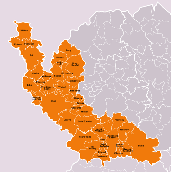
Okres Cheb
| Okres Cheb | |
|---|---|
| Kraj | Karlovarský kraj |
| surface | 1,045.93 km² |
|
Inhabitants • Population density |
91,540 ( January 1, 2019 ) 89 inhabitants / km² |
|
Municipalities • of which cities • of which Městyse |
40 10 0 |
| LAU 1 | CZ0411 |
|
Vehicle registration number (issued until 2001) |
CH |

|
|
The Okres Cheb (translated as Eger District ) is the westernmost district of the Czech Republic (Czech Republic) . The territory is part of the Karlovy Vary Region ( Karlovarský kraj ). It has an area of 1046 km². Its 93,112 inhabitants are distributed over 40 cities and municipalities (Obec) with 183 districts (část obcí).
history
The district of Eger in the Kingdom of Bohemia of the Habsburg Monarchy came into being in the 19th century, was inhabited by Germans and was territorially changed several times.
According to the Munich Agreement , the city of Eger formed its own urban district between 1938 and 1945 , but was also the seat of the district of Eger . The town and district of Eger were part of the German Empire along with the Sudetenland .
After the Germans were driven out , the area was populated by the Czechs. In 1960 the Okres Cheb was enlarged through the merger with the Okres Aš and a large part of the Okres Mariánské Lázně .
On January 1, 2007, the town of Teplá was added from the Okres Karlovy Vary .
economy
In 2003 there were 20,512 employees in Okres Cheb. They earned an average of CZK 13,897 a month . The unemployment rate was 8.34%.
There are some raw material deposits in the district such as coal, brick clay, granite and crushed stone.
Mainly grain is grown in the Eger Basin. As in most parts of the former ČSSR , fruit growing suffered during the years of collective farming. There is textile industry and mechanical engineering (both in Cheb and Aš ). Luby used to be called the Cremona of Austria because of its manufacture of stringed instruments . In addition to production, there is also a technical school for instrument making in Luby . Porcelain and other ceramics are made in Skalná .
Tourism plays a major role in the district, especially through spa stays and the scenic charm. 1,750,956 tourists, almost three quarters of them foreigners, stayed in the district for an average of 7.3 days. The medicinal springs near Mariánské Lázně with 40 salt and iron springs and Františkovy Lázně with 24 mineral springs are of particular importance .
cities and communes
- (Cities are marked in bold)
- Aš (ash)
- Dolní Žandov (Untersandau)
- Drmoul (skinny mouth)
- Františkovy Lázně (Franzensbad)
- Hazlov (Haslau)
- Hranice (Rossbach)
- Cheb (Eger)
- Krásná (Schönbach near Asch)
- Křižovatka (Klinghart)
- Lázně Kynžvart (Königswart Spa)
- Libá (Liebenstein)
- Lipová (Lindenhau)
- Luby (Schönbach)
- Mariánské Lázně (Marienbad)
- Milhostov (mill meal)
- Milíkov (Miltigau)
- Mnichov (Einsiedl (Kaiserwald))
- Nebanice (Nebanitz)
- Nový Kostel (Neukirchen)
- Odrava (Kulsam)
- Okrouhlá (Scheibenreuth)
- Ovesné Kladruby (Habakladrau)
- Plesná (Fleißen)
- Podhradí (Neuberg)
- Pomezí nad Ohří (Mühlbach)
- Poustka (Oed)
- Prameny (Sangerberg)
- Skalná (Wildstein)
- Stará Voda (backwater)
- Teplá ( Teplá )
- Trstěnice (Neudorf bei Plan)
- Třebeň (Trebendorf)
- Tři Sekery (three hooks)
- Tuřany (Thurn)
- Valy (Schanz)
- Velká Hleďsebe (Groß sichdichfür)
- Velký Luh (Großloh)
- Vlkovice (Wilkowitz)
- Vojtanov (Voitersreuth)
- Zádub-Závišín (Hohendorf - Abaschin)
Individual evidence
- ↑ Územně identifikační registr ČR ( Territorial Identification Register of the Czech Republic )
Web links
Coordinates: 50 ° 4 ′ N , 12 ° 29 ′ E
