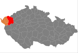
Okres Karlovy Vary
| Okres Karlovy Vary | |
|---|---|
| Kraj | Karlovarský kraj |
| surface | 1,514.50 km² |
|
Inhabitants • Population density |
115,014 ( January 1, 2019 ) 77 inhabitants / km² |
|
Municipalities • of which cities • of which Městyse |
56 12 0 |
| LAU 1 | CZ0412 |
|
Vehicle registration number (issued until 2001) |
KV |

|
|
The Czech Okres Karlovy Vary (German district Karlsbad ) is located in north-west Bohemia and extends from the southern slope of the Ore Mountains to the Duppau Mountains and Tepler Highlands . Around 117,800 inhabitants live on 1,515 km² in 56 cities and municipalities as well as 241 districts ( část obcí ) and 325 basic settlement units ( Základní sídelní jednotka , ZSJ).
history
The Okres Karlovy Vary territorial unit was established in 1960 from the former districts of Karlovy Vary, Toužim and the eastern part of Mariánské Lázně and a small part of Podbořany and Kadaň . The Okresy were dissolved as regional authorities on December 31, 2002.
On January 1, 2007, the city of Teplá ( Tepl ) moved to the Okres Cheb . As part of the downsizing of the military training areas, the municipalities of Bražec and Doupovské Hradiště were formed at the beginning of 2016 .
economy
The district is known for thermal springs in Karlovy Vary and radioactive water in Jáchymov . Kaolin is also found in the district , which is used as a raw material for the ceramic industry. Stone, sand, bentonite and wood are also extracted.
The historical development of industry was closely related to the ore deposits in the Ore Mountains . Tourism is relatively important today, attracting around 318,000 guests a year (190,000 of them foreigners) who usually stay for seven days. Traditional industrial companies are dedicated to the porcelain and glass industries, bottling mineral water (“ Mattoni ”) and the production of liqueurs (“ Becherovka ”). Agriculture is primarily concerned with growing grain and keeping pigs.
28,000 companies are registered in the district, the annual growth rate was 8.8% (as of 2005).
cities and communes
(Cities are marked in bold)
- Abertamy ( Abertham )
- Andělská Hora ( Angel House )
- Bečov nad Teplou ( Petschau )
- Bochov ( Buchau )
- Boží Dar ( God's gift )
- Božičany ( Poschetzau )
- Bražec ( Bergles )
- Březová ( Pirkenhammer )
- Černava ( Schwarzenbach )
- Čichalov ( Sichlau )
- Dalovice ( Dallwitz )
- Děpoltovice ( greenery )
- Doupovské Hradiště
- Hájek ( grass green )
- Horní Blatná ( mountain town Platten )
- Hory ( Horn near Neusattl )
- Hroznětín ( Lichtenstadt )
- Chodov ( Gängerhof )
- Chyše ( Chiesch )
- Jáchymov ( Saint Joachimsthal )
- Jenišov ( Janessen )
- Karlovy Vary ( Carlsbad )
- Kolová ( Kohlhau )
- Krásné Údolí ( Schönthal )
- Krásný Les ( Schönwald )
- Kyselka ( Gießhübl-Sauerbrunn )
- Merklín ( Merkelsgrün )
- Mírová ( Münchhof )
- Nejdek ( Neudek )
- Nová Role ( New Rohlau )
- Nové Hamry ( Neuhammer )
- Ostrov ( Schlackenwerth )
- Otovice ( Ottowitz )
- Otročín ( Landeck )
- Pernink ( Bärringen )
- Pila ( cutting mill )
- Potůčky ( Breitenbach (Ore Mountains) )
- Pšov ( Schaub )
- Sadov ( Sodau )
- Smolné Pece ( pitch ovens )
- Stanovice ( Donawitz )
- Stráž nad Ohří ( Warta )
- Stružná ( Gießhübel near Buchau )
- Šemnice ( Schömitz )
- Štědrá ( Stiedra )
- Teplička ( pottery )
- Toužim ( Theusing )
- Útvina ( Uitwa )
- Valeč ( Waltsch )
- Velichov ( Welchau )
- Verušičky ( Klein-Werscheditz )
- Vojkovice ( Wickwitz )
- Vrbice ( Großfürwitz )
- Vysoká Pec ( blast furnace near Neudek )
- Žlutice ( Luditz )
Training area:
- Hradiště ( TÜP )
Individual evidence
Web links
Coordinates: 50 ° 13 ' N , 13 ° 0' E
