
Horní Blatná
| Horní Blatna | |||||
|---|---|---|---|---|---|
|
|||||
| Basic data | |||||
| State : |
|
||||
| Region : | Karlovarský kraj | ||||
| District : | Karlovy Vary | ||||
| Area : | 562.6542 ha | ||||
| Geographic location : | 50 ° 23 ' N , 12 ° 46' E | ||||
| Height: | 902 m nm | ||||
| Residents : | 412 (Jan 1, 2019) | ||||
| Postal code : | 362 37 | ||||
| License plate : | K | ||||
| traffic | |||||
| Railway connection: | Karlsbad – Johanngeorgenstadt | ||||
| structure | |||||
| Status: | city | ||||
| Districts: | 1 | ||||
| administration | |||||
| Mayor : | Robert Petro (as of 2011) | ||||
| Address: | Náměstí Sv. Vavřince 1 362 37 Horní Blatná |
||||
| Municipality number: | 555169 | ||||
| Website : | www.horni-blatna.cz | ||||
| Location of Horní Blatna in the Karlovy Vary district | |||||

|
|||||


Horní Blatná ( German Bergstadt Platten ) is a town in the Czech Republic not far from the German border near Johanngeorgenstadt in the Bohemian Ore Mountains .
geography

location
The city is located in western Bohemia in a flat depression of the ridge plateau of the Bohemian Ore Mountains on the southwest slope of the Plattenberg ( Blatenský vrch ).
Neighboring places
| Potůčky (Breitenbach) | ||
.svg)
|
||
| Nové Hamry (Neuhammer near Karlsbad) | Pernink (Bärringen) |
history


Platten was founded by Schneeberg miners who opened a tin mine on the Plattenberg in 1532 and named the mine St. Wolfgang. Elector John Frederick of Saxony ordered on 10 July 1534 at the initiative of the knight and captain Hans von Weissenbach from Schneeberg of Torgau from the planned establishment of a new mining town in the Ore Mountains.
The city was laid out like a chessboard based on the model of the mining town of Marienberg, founded in 1521, for 199 farms. The floor plan comes from an idea by the Saxon mountain master Joachim Spanseil from Schwarzenberg . The site was drained, then a schematic church, school and town hall were built. The first execution with the sword took place in the winter of 1545 on the market square in Platten.
Due to the Wittenberg surrender on May 19, 1547, which ended the Schmalkaldic War , Platten was ceded to the Kingdom of Bohemia .
The predominantly Protestant population was forced to leave the city in 1653 under the pressure of the Counter Reformation ; a large part went over the Saxon border and founded Johanngeorgenstadt in 1654 . The city was repopulated from the interior of Bohemia, but never regained its former size and importance. The production of bobbin lace , gloves and sheet metal and iron goods (e.g. spoons) brought a new, modest upswing.
In 1766, Emperor Joseph II is said to have stayed in the Heßlerisches Haus in Platten under the synonym of a Count von Burgau and there accepted requests from residents. Because of the overpriced grain prices, a great famine broke out in the Ore Mountains between 1771 and 1772, which killed many people. In 1772 there were 397 deaths in the parish of Platten alone.

Street train

Street corner

Eispinge
Wolf spinge


In 1850 the municipality became the seat of the Platten judicial district and from 1910 belonged to the Neudek district . The snow-sure location of the place favored the development of winter sports after 1900. In summer, numerous summer visitors stayed in the place and relaxed in the wooded area.
After the First World War , Bergstadt Platten was added to the newly created Czechoslovakia in 1919 . Due to the Munich Agreement , the place came to the German Reich in 1938 and until 1945 belonged to the Neudek district , Eger district , in the Reichsgau Sudetenland . In the census on May 17, 1939, 2210 inhabitants were counted in the mountain town of Platten.
After the end of World War II , the mining town of Platten was taken over by Czechoslovakia. This was followed by the expulsion of the majority of the German-speaking population of the place in 1946. Many of the now vacant houses then fell into disrepair, as a resettlement with Czechs was only possible to a limited extent. After 1990, the Vietnamese settled in the nearby Potůčky border markets. Since January 23, 2007 Horní Blatná has city rights again .
Demographics
| year | Residents | Remarks |
|---|---|---|
| 1783 | k. A. | 186 houses |
| 1830 | 1,705 | in 241 houses |
| 1847 | 2.007 | in 244 houses, all of them German residents, except for two Protestant families, all Catholics |
| 1869 | 2.213 | |
| 1880 | 2,340 | |
| 1890 | 2,524 | |
| 1900 | 2,771 | German residents |
| 1910 | 2,749 | |
| 1921 | 2.163 | thereof 2,090 German residents |
| 1930 | 2,341 | |
| 1939 | 2,215 |
| year | 1950 | 1961 | 1970 | 1980 | 1991 | 2001 | 2004 3 | 2005 3 | 2006 3 | 2007 3 | 2008 3 | 2009 3 | 2010 3 | 2011 1 | 2012 3 | 2013 3 | 2014 3 |
|---|---|---|---|---|---|---|---|---|---|---|---|---|---|---|---|---|---|
| Residents | 1098 | 813 | 582 | 448 | 367 | 468 | 421 | 409 | 399 | 395 | 394 | 389 | 391 | 381 | 379 | 381 | 383 |
German place name
The German name of the place was originally just plates or plates near Karlsbad . But since there was always confusion with other places, e.g. B. with plates near Komotau, the official name Bergstadt Platten was determined when the place names were redefined in 1918 .
Mining
Since the 15th century, Schneeberg miners have been digging for tin on the Plattenberg. The Harz counts of Mansfeld have also been involved in soap mining in this area since 1519 at the latest and can be traced back to the Lauterseifen am Hirschberg as miners. As early as 1535 there were over 300 mines and rocks here . The Plattener Bergrevier comprised several mountain towns that were also built in the 16th century, including Gottesgab , Abertham , Zwittermühl and Bärringen .
The mining yields were paid to the Saxon electors until 1556 , after which Saxony and Bohemia shared the tithe . Mining reached its peak in the middle of the 16th century; in 1565 almost 1,700 quintals were mined. After that, funding was reduced due to inadequately developed mining technologies. In the Thirty Years War , the production came to a largely standstill.
The ennobled mine owner Johann Franz von Heßler gave the city the last heyday of mining. After his death, most of the mines were closed, which caused the mining industry to decline rapidly. In 1806 Kajetan Putz is mentioned as the last 31st mountain master and in 1847 the last mountain jury was retired. In 1848 the mining authority was finally abolished.
The Horní Blatná mining landscape has been a selected site in the Ore Mountains Mining Region UNESCO World Heritage Site since June 2019 .
traffic

Since 1899 there has been a railway connection across the border to Johanngeorgenstadt and inland via the Ore Mountains to Karlovy Vary ( Karlsbad ).
Regular buses run via Pernink ( Bärringen ) and Ostrov ( Schlackenwerth ) to Karlovy Vary.
Attractions

Horní Blatná is one of the best preserved mining towns from the 16th century in the Bohemian Ore Mountains. Since 1992, the city has been under monument protection in large parts as a valuable example of a systematically founded mining town.
Sights include:
- Baroque church of St. Lawrence ( Svatého Vavřince ) from 1594
- Cemetery with cross chapel ( Kaple sv.Kříže ) from 1744
- Horní Blatná Museum (including the Tin Museum)
- Plattner artificial moat : The approx. 13 km long artificial moat , built in 1540 for mining water management, leads from Boží Dar to Horní Blatná. A nature trail partially runs along the trench.
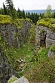
- Blatenský vrch ( Plattenberg ) with a lookout tower as well as wolf and ice penguins
- Na strašidlech ( Heinrichstein ), hilltop with legendary rock massif
Personalities
sons and daughters of the town
- Kilian Rebentrost (1582–1661), Lutheran clergyman, preacher on the mount in Annaberg
- Martin Päßler (1586–1651), entrepreneur, owner of a blue paint factory
- Johann Löbel (1592–1666), city judge and mountain master, mayor of Johanngeorgenstadt
- Georg Abraham Löbel (1604–1685), mountain master, councilor and court assessor
- Christoph Haas (1609–1679), mountain master, governor and chamberlain
- Gabriel Hammerdörffer (1612–1683), tin publisher and local politician
- Melchior Siegel (1613–1689), city judge, church mayor and founder
- Johann Poppenberger (1618–1690), mine owner, councilor and city judge
- Abraham Wenzel Löbel (1631–1707), mountain master in Johanngeorgenstadt
- Johannes Georgi (1632–1707), educator, rector in Johanngeorgenstadt for over 50 years
- Johann Bleyer (1639–1722), member of the Saxon state parliament, mayor of Johanngeorgenstadt
- Johann Jahn (1644–1716), German Lutheran theologian
- Benedict Drechsler (1651–1690), Saxon mountain surveyor and chemist
- Christoph Adalbert Putz (1658–1726), mountain master, glassworks and blue paint factory owner
- Joseph Putz (1672–1730), customs officer, blue paint factory owner and mine owner
- Wenzel Leopold Putz von Breitenbach (1688–1747), Bohemian landowner
- Barbara Heßler (1695–1747), coal and steel entrepreneur and beneficiary
- Johann Nepomuk Mießl (1733–1802), senior administrator, mountain judge and local researcher
- Johann Anton Seeling (1743–1822) mineralogist, senior administrator and mountain ridge in Wieliczka
- Adalbert Hahn (1750–1825), Father Hahn - the Faust of the Ore Mountains
- Kajetan Putz (1755–1825), 31st and last mountain master of Platten
- Franz Anton Kerl (1770–1849), trader, publisher and spoon manufacturer
- Felix Mießl (1778–1861), mayor of Wiener Neustadt and founder of Felixdorf
- Felix Kerl (1802–1876), kk privileged lace and blue paint manufacturer, wholesaler
- Hans Soph (1869–1954), dialect poet and singer from the Ore Mountains
People related to the city
- Wolf Schaller († after 1536), mining entrepreneur, co-founder of the city
- Georg Körner († before 1582), juror in St. Joachimsthal, mountain master
- Gabriel Siegel († after 1624), tin dealer, hammer owner, tithe, mountain master and city judge
- Anna Strassberger (* around 1535), blacksmith's daughter who was expelled from the devil in 1559
- Elias Richter (1597–1678), schoolmaster in Platten, later pastor in Raschau
- Johann Jahn (1604–1651), pastor in Platten und Kürbitz
- Paul Wenzel Seeling (around 1617–1693), forest ranger, city judge, mountain master and mint administrator
- Peter Kuhn (around 1628–1682), mountain master and entrepreneur
- Johann Putz (around 1631–1697), local politician, border customs collector, city treasurer and city bailiff
- Hans Adam Siegel (1638–1679), forest hunter and forester, tin tithe collector, mountain clerk
- Johann Friedrich Hacker (1666–1697), forest rider and mountain master
- Theodor Sichelbarth († 1710), border customs officer, town clerk, schoolmaster and cantor
- Johann Franz von Heßler (1693–1770), border customs collector and mine owner, imperial councilor
literature
- Jörg Brückner , Kurt Burkhardt, Reinhart Heppner , Roland Stutzky: The Schwarzwassertal from the Fichtelberg to the Zwickauer Mulde in historical views. Geiger, Horb am Neckar 1993, ISBN 3-89264-770-4 , p. 31 ff.
- Homeland register of the Neudek district. 2nd Edition. Home group Glück Auf Landkreis Neudek, Augsburg-Göggingen 1978.
- Erich Matthes : The beginnings of the mountain town of Platten. In: Bohemia . Journal of the history and culture of the Czech lands. Volume 1, 1960, pp. 122-152 ( digitized version ).
- Horst Pohl: Bergstadt Platten. Economic-cultural relations and internal migration in the Bohemian-Saxon Ore Mountains 1532–1938. In: Bohemia. Journal of the history and culture of the Czech lands. Volume 6, 1965, pp. 173-229 ( digitized version ).
- Robert Jahn : On the flat. Contribution to the 400th anniversary of our mother city from 1532–1654. Schindler, Johanngeorgenstadt 1932.
- Mining monuments in the mining region Erzgebirge / Krusnohory, German / Czech, Karlovarsky Kraj (Karlsbad region) 2014, nomination documentation for the project "Montane cultural landscape Erzgebirge-Krusnohory" (Municipal monument protection zone Horni Blatna p. 37–38, Wolfspinge and Eispinge p. 39) .
- Ways of the cultural heritage: A guide through the important mining monuments of the western (Bohemian) Ore Mountains, The way of the mining monuments, mountain town Platten (Horni Blatna) p. 18–24, Karlovy Vary Region and National Monument Institute of the Czech Republic, Karlovy Vary 2013, German, ISBN 978- 80-87104-73-6
Web links
- Homepage of the municipal administration (German)
- Local family book on genealogy.net
Individual evidence
- ↑ http://www.uir.cz/obec/555169/Horni-Blatna
- ↑ Český statistický úřad - The population of the Czech municipalities as of January 1, 2019 (PDF; 7.4 MiB)
- ^ A b Johann Gottfried Sommer : The Kingdom of Bohemia . Volume 15: Elbogner Kreis , Prague 1847, pp. 83–84.
- ^ Christian Adolf Peschek : History of the Counter Reformation in Bohemia . Volume 1, 2nd edition, Leipzig 1850, p. 549 .
- ↑ Jaroslaus Schaller : Topography of the Kingdom of Bohemia. Volume 2: Ellbogner Kreis. Prague 1785, pp. 95–96, paragraph 18 .
- ↑ Yearbooks of the Bohemian Museum of Natural and Regional Studies, History, Art and Literature . Volume 2, Prague 1831, p. 199, item 9).
- ^ Meyer's Large Conversational Lexicon . 6th edition, Volume 16, Leipzig and Vienna 1908, p. 27 .
- ^ Sudetenland Genealogy Network
- ^ A b Michael Rademacher: German administrative history from the unification of the empire in 1871 to the reunification in 1990. Neudek district (Czech. Nejdek). (Online material for the dissertation, Osnabrück 2006).
- ↑ Historický lexikon obcí České republiky - 1869-2015. (PDF) Český statistický úřad, December 18, 2015, accessed on January 16, 2016 (Czech).
- ↑ Počty obyvatel v obcích (2001-2013). Ministerstvo vnitra České republiky, 2015, accessed January 8, 2016 (Czech).