
Pila u Karlových Var
| Pila | |||||
|---|---|---|---|---|---|
|
|||||
| Basic data | |||||
| State : |
|
||||
| Region : | Karlovarský kraj | ||||
| District : | Karlovy Vary | ||||
| Area : | 710.7811 ha | ||||
| Geographic location : | 50 ° 11 ' N , 12 ° 56' E | ||||
| Height: | 550 m nm | ||||
| Residents : | 535 (Jan. 1, 2019) | ||||
| Postal code : | 360 01 | ||||
| License plate : | K | ||||
| traffic | |||||
| Street: | Útvina - Karlovy Vary | ||||
| Next international airport : | Karlovy Vary Airport | ||||
| structure | |||||
| Status: | local community | ||||
| Districts: | 1 | ||||
| administration | |||||
| Mayor : | Stanislav Hoffman (as of 2008) | ||||
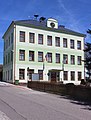
| Address: | Pila 97 360 01 Karlovy Vary 1 |
||||
| Municipality number: | 556947 | ||||
| Website : | www.kr-karlovarsky.cz/obce/Pila | ||||
| Location of Pila in the Karlovy Vary district | |||||

|
|||||


Pila (German Schneidmühl ) is a municipality in the Czech Republic . It is located six kilometers southeast of Karlovy Vary and belongs to the Okres Karlovy Vary .
geography
Pila is located on the edge of the Imperial Forest in the Lomnický potok valley . To the north lies the Karlovy Vary airport and to the west the Stanovice reservoir . To the south there are tunnels and heaps of the former mining industry.
Neighboring towns are Olšová Vrata in the north, Andělská Hora in the northeast, Žalmanov, Peklo and Nová Víska in the east, Podlesí and Dlouhá Lomnice in the southeast, Rybničná, Nové Kounice and Dolní Dražov in the south, Dražov , Nové Stanovice and Stanovice in the west, and Cihelny in the west and Kolová in the northwest.
history
Since 1597 there has been a mill in the Lammitzbach valley, which belongs to the Bečov nad Teplou estate , and its existence has been documented since the 1620s. A cutting mill was added later. During the Thirty Years War, the settlement was ravaged by Swedish troops. In the berní rula of 1654 , six people including three charcoal burners are shown for Schneidmühl, which was part of the Funkenstein cadastre . In 1713 Schneidmühl formed its own village community with a Schulzen. By 1780 the village had grown to 43 houses. During the rule of Dominik von Kaunitz , the village was enlarged. In 1840 Schneidmühl consisted of 92 houses and had 579 inhabitants.
After the abolition of patrimonial , Schneidmühl / Pila formed a political municipality in the Karlsbad district from 1850. Iron ore was mined south of Pila from 1880 onwards. Later on Uhelný vrch near Dražov was the mining of brown and waxy coal, which was stopped in 1968. In 1901 the village consisted of 118 houses in which 725 German Bohemians lived. In 1930 the community had 829 inhabitants. As a result of the Munich Agreement , Schneidmühl was annexed to the German Reich in 1938. In 1939, 835 people lived in Schneidmühl. From 1938 to 1945 the municipality was part of the German district of Karlsbad and came back to Czechoslovakia after the end of the Second World War. From 1945 onwards 160 German families were expelled and the Czech population settled.
From 1946 to 1960 Pila belonged to the Okres Karlovy Vary-okolí and since 1961 again to the Okres Karlovy Vary. Between 1976 and 1999 Pila was incorporated into Kolová .
Community structure
No districts have been identified for the municipality of Pila. The settlement Telenec ( Kalmstall ) belongs to Pila .
Attractions
- Chapel in the cemetery, consecrated in 1936
- Wackelstein ( Vyklan ), south of the village on the eastern hand of the Výhledy above the valley of the Javorná stream
Local authority

Lomnický brook

