Stanovice u Karlových Var
| Stanovice | ||||
|---|---|---|---|---|
|
||||
| Basic data | ||||
| State : |
|
|||
| Region : | Karlovarský kraj | |||
| District : | Karlovy Vary | |||
| Area : | 3,161.1546 ha | |||
| Geographic location : | 50 ° 11 ' N , 12 ° 52' E | |||
| Height: | 558 m nm | |||
| Residents : | 630 (Jan. 1, 2019) | |||
| Postal code : | 360 01 | |||
| License plate : | K | |||
| traffic | ||||
| Street: | Útvina - Karlovy Vary | |||
| Next international airport : | Karlovy Vary Airport | |||
| structure | ||||
| Status: | local community | |||
| Districts: | 4th | |||
| administration | ||||
| Mayor : | Alice Kondelčíková (as of 2010) | |||
| Address: | Stanovice 44 360 01 Karlovy Vary 1 |
|||
| Municipality number: | 555550 | |||
| Website : | www.obecstanovice.cz | |||
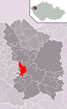
| Location of Stanovice in the Karlovy Vary district | ||||

|
||||
Stanovice (German Donawitz ) is a municipality in the Czech Republic . It is located seven kilometers south of Karlovy Vary and belongs to the Okres Karlovy Vary .
geography
Stanovice is located on the edge of the Imperial Forest in the area of the ChKO Slavkovský les protected landscape area on the U Křižku ridge (610 m) between the Teplá and Lomnický potok valleys . East of the village is situated on Lomnický potok the Dam Stanovice .
Neighboring towns are Březová and Háje in the north, Kolová and Pila in the north-east, Podlesí and Nové Stanovice in the east, U Močidel and Dolní Dražov in the south-east, Dražov in the south, Teplička in the south-west, Bošířany, Nadlesí and Údolí in the west and Cihelny in the north-west.
history
The village was first mentioned in documents in 1358 in connection with the church. It is believed that the village was founded by the Hrabischitz family . After the abolition of patrimonial Donawitz / Stanovice formed a community in the Karlsbad district from 1850. In 1930 there were 1076 people in Donawitz. As a result of the Munich Agreement , Donawitz was annexed to the German Reich in 1938 and assigned to the Karlsbad district . The Czech residents were forcibly evicted. In 1939 the community had 953 inhabitants. After the end of the Second World War , the village came back to Czechoslovakia . Most Germans were expelled from 1945 onwards . On the night of October 14-15, 1951, there was a shooting near Stanovice when eleven prisoners managed to escape from shaft 14 of the Joachimsthal uranium mines near Horní Slavkov . From 1946 to 1960 Stanovice belonged to the Okres Karlovy Vary-okolí and since 1961 again to the Okres Karlovy Vary.
Community structure
The Stanovice municipality consists of the districts Dražov ( Trossau ), Hlinky ( glue pits ), Nové Stanovice ( New Donawitz ) and Stanovice ( Donawitz ). Basic settlement units are Dolní Dražov ( Untertrossau ), Hlinky, Horní Dražov ( Obertrossau ), Nové Stanovice and Stanovice. U Močidel also belongs to Stanovice.
The municipality is divided into the cadastral districts Dražov, Hlinky and Stanovice.
Attractions
- Half-timbered houses
- Church in Stanovice
Individual evidence
- ↑ http://www.uir.cz/obec/555550/Stanovice
- ↑ Český statistický úřad - The population of the Czech municipalities as of January 1, 2019 (PDF; 7.4 MiB)
- ↑ http://www.uir.cz/casti-obce-obec/555550/Obec-Stanovice
- ↑ http://www.uir.cz/zsj-obec/555550/Obec-Stanovice
- ↑ http://www.uir.cz/katastralni-uzemi-obec/555550/Obec-Stanovice

