Hájek u Ostrova
| Hajek | ||||
|---|---|---|---|---|
|
||||
| Basic data | ||||
| State : |
|
|||
| Region : | Karlovarský kraj | |||
| District : | Karlovy Vary | |||
| Area : | 875.0208 ha | |||
| Geographic location : | 50 ° 17 ′ N , 12 ° 54 ′ E | |||
| Height: | 473 m nm | |||
| Residents : | 623 (Jan. 1, 2019) | |||
| Postal code : | 363 01 | |||
| License plate : | K | |||
| traffic | ||||
| Street: | Karlovy Vary - Ostrov nad Ohří | |||
| Railway connection: | Chomutov – Cheb | |||
| Next international airport : | Karlovy Vary Airport | |||
| structure | ||||
| Status: | local community | |||
| Districts: | 2 | |||
| administration | ||||
| Mayor : | Vít Hromádko (as of 2008) | |||
| Address: | Hájek 68 363 01 Ostrov nad Ohří |
|||
| Municipality number: | 538159 | |||
| Website : | www.obechajek.cz | |||
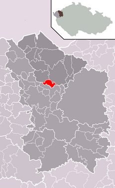
| Location of Hájek in the Karlovy Vary district | ||||

|
||||
Hájek (German grass green ) is a municipality in the Czech Republic . It is located seven kilometers northwest of Karlovy Vary and belongs to the Okres Karlovy Vary .
geography
Hájek is located at the transition from the Falkenauer Basin to the Duppauer Gebirge . To the west of the village rises the Jahodník (540 m). In the east run the Chomutov – Cheb railway line and the 13 / E 442 state road between Karlovy Vary and Ostrov .
Neighboring towns are Bystřice and Kfely in the north, Ostrov , Liticov and Mořičov in the north-east, Nejda and Ovčárna in the east, Nová Víska in the south-east, Lesov in the south, Sadov and Liščí Díra in the south-west, Velký Rybník in the west and Hroznětín in the north-west.
history
The first written mention of Grasengrün comes from 1409. From the beginning of the 16th century until the abolition of patrimonial rule, the village was subject to Schlackenwerth . The owners of the village included the Schlicken and the dukes of Saxony-Lauenburg . In 1690 the Margraves of Baden acquired the property by marriage. Later the goods came to Ferdinand III.
From 1850, Grasengrün and the Fuchsloch district formed a political municipality in the Karlsbad district. With the completion of the railway from Schlackenwerth to Karlsbad, Grasengrün was connected to the railway network in 1871. In 1930 the community had 597 inhabitants. As a result of the Munich Agreement , it was annexed to the German Reich in 1938. In 1939 543 people lived in Grasengrün. From 1938 to 1945 Grasengrün was part of the German district of Karlsbad and came back to Czechoslovakia after the end of the Second World War. From 1946 to 1960 the municipality, which was renamed Hájek in 1948, belonged to Okres Karlovy Vary-okolí and since 1961 again to Okres Karlovy Vary. In 1961 Nová Víska was incorporated. Between 1978 and 1990 Hájek was a part of Sadov .
Community structure
The municipality of Hájek consists of the districts of Hájek ( grass green ) and Nová Víska ( Neudörfl ), which also form cadastral districts. Basic settlement units are Hájek, Nejda ( Neudau ) and Nová Víska. The Ovčárna ( sheep farm ) settlement also belongs to Hájek .
Attractions
- Chapel of St. John of Nepomuk
- Plague column, erected in the first half of the 18th century
Individual evidence
- ↑ http://www.uir.cz/obec/538159/Hajek
- ↑ Český statistický úřad - The population of the Czech municipalities as of January 1, 2019 (PDF; 7.4 MiB)
- ↑ http://www.uir.cz/casti-obce-obec/538159/Obec-Hajek
- ↑ http://www.uir.cz/katastralni-uzemi-obec/538159/Obec-Hajek
- ↑ http://www.uir.cz/zsj-obec/538159/Obec-Hajek

