Tři Sekery
| Tři Sekery | ||||
|---|---|---|---|---|
|
||||
| Basic data | ||||
| State : |
|
|||
| Region : | Karlovarský kraj | |||
| District : | Cheb | |||
| Area : | 4118.0879 ha | |||
| Geographic location : | 49 ° 57 ' N , 12 ° 37' E | |||
| Height: | 665 m nm | |||
| Residents : | 948 (Jan. 1, 2019) | |||
| Postal code : | 354 73 | |||
| License plate : | K (old CH) | |||
| structure | ||||
| Status: | local community | |||
| Districts: | 4th | |||
| administration | ||||
| Mayor : | Dagmar Strnadová (as of 2018) | |||
| Address: | Tři Sekery 82 353 01 Mariánské Lázně 1 |
|||
| Municipality number: | 554880 | |||
| Website : | mesta.obce.cz/trisekery | |||
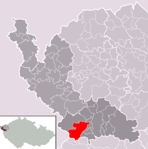
| Location of Tři Sekery in the Cheb district | ||||

|
||||
Tři Sekery ([ tr̝̊ɪ ˈsɛkɛri ]) (German Dreihacken ) is a municipality in the Czech Republic and belongs to the Okres Cheb .
geography
Geographical location
The place is 665 m above sea level. M. in the eastern foothills of the Upper Palatinate Forest . In Broumov , to the south, there is a border crossing for motor vehicles to Mähring . Neighboring towns are Krásné in the north, Velká Hleďsebe and Drmoul in the east, and Chodovská Huť in the south. In the west rises the 792 m high Tišina ( Die Ruh ) peak , behind which the Slatina ( Lohhäuser ) desert is located on the German border .
Community structure
The community of Tři Sekery consists of the districts Chodovská Huť ( Kuttenplaner Schmelzthal ), Krásné ( Schönthal ), Tachovská Huť ( Tachauer Schmelzthal ) and Tři Sekery ( Dreihacken ). Basic settlement units are Chodovská Huť, Krásné, Plánská Huť ( Planer Schmelzthal ), Tachovská Huť, Tři Sekery u Kynžvartu ( Königswarther Dreihacken ) and Tři Sekery u Tachova ( Tachauer Dreihacken ).
The municipality is divided into the cadastral districts of Chodovská Huť, Krásné u Tří Seker, Plánská Huť, Tachovská Huť, Tři Sekery u Kynžvartu and Tři Sekery u Tachova.
history
In the first half of the 16th century, rich ore deposits were discovered in the stately forests of the Dreihackener Joch . In 1536 Kaspar Pflugk von Rabenstein had the first mines built to extract copper ore . Smelting works and settlements for miners and smelters were built near the mines. In the 17th century, mining expanded to include lead , silver and cobalt . In 1736 the known deposits were exhausted and the mines were closed.
Exactly one hundred years later, the resumption began with the excavation of two deep tunnels at Dreihacken. Until the 19th century, was made extraction of cobalt and silver, also the old copper mines Elias coal mine and coal mine Stephani were put back into operation. Uranium ore deposits were discovered in 1916 and 1923 .
Until after the Second World War there were several independent villages in what is now the municipality. Those were
- the Kuttenplaner Schmelzthal ( Chodovská Huť ) and the planner Schmelzthal ( Plánská Huť ), which belonged to the planner and later to the Tachau district. In the Marienbad district were
- Schönthal ( Krásné ), consisting of Großschönthal ( Velké Krásné ), Kleinschönthal ( Malé Krásné ) and Neu Metternich or the Metternich three-hoe ( Nový Metternich ),
- Tachauer Dreihacken ( Tři Sekery u Tachova ) including Hohlenstein ( Kamenec )
- Tachauer Schmelzthal ( Tachovská Huť ) and the
- Königswarther Dreihacken ( Tři Sekery u Kynžvartu ).
After mining and huts were extinct, the Dreihackener Joch is now a recreational area that benefits from the wealth of forests in the area and its seclusion.
Web links
Individual evidence
- ↑ http://www.uir.cz/obec/554880/Tri-Sekery
- ↑ Český statistický úřad - The population of the Czech municipalities as of January 1, 2019 (PDF; 7.4 MiB)
- ↑ http://www.uir.cz/casti-obce-obec/554880/Obec-Tri-Sekery
- ↑ http://www.uir.cz/zsj-obec/554880/Obec-Tri-Sekery
- ↑ http://www.uir.cz/katastralni-uzemi-obec/554880/Obec-Tri-Sekery


