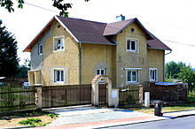
Okrouhlá u Chebu
| Okrouhlá | ||||
|---|---|---|---|---|
|
||||
| Basic data | ||||
| State : |
|
|||
| Region : | Karlovarský kraj | |||
| District : | Cheb | |||
| Area : | 1043.4027 ha | |||
| Geographic location : | 50 ° 3 ' N , 12 ° 29' E | |||
| Height: | 445 m nm | |||
| Residents : | 252 (Jan. 1, 2019) | |||
| Postal code : | 350 02 | |||
| License plate : | K (old CH) | |||
| traffic | ||||
| Street: | Cheb - Planá | |||
| structure | ||||
| Status: | local community | |||
| Districts: | 2 | |||
| administration | ||||
| Mayor : | Petr Zetocha (as of 2018) | |||
| Address: | Okrouhlá 47 350 02 Cheb 2 |
|||
| Municipality number: | 538922 | |||
| Website : | www.obec-okrouhla.cz | |||
| Location of Okrouhlá in the Cheb district | ||||

|
||||
Okrouhlá (German Scheibenreuth ) is a municipality in the Czech Republic . It is located nine kilometers east of the city center of Cheb and belongs to the Okres Cheb .
geography
Geographical location
Okrouhlá is located in the southeast of the Eger Basin on the Jesenice reservoir . To the north rises the hill Rovina ( Vorderlustberg , 481 m). State road 21 between Cheb and Planá runs through the village . In the south lies the Lažanský les forest area.
Community structure
The community Okrouhlá consists of the districts Jesenice ( Gaßnitz ) and Okrouhlá ( Scheibenreuth ), which also form cadastral districts. Okrouhlá also includes the Nový Dvůr ( Neuhof ) desert .
Neighboring communities
Neighboring towns are Trpěš and Lipoltov in the north, Tuřany in the northeast, Úval and Velká Šitboř in the east, Žírnice in the southeast, Salajna, Dolní Lažany and Horní Lažany in the south, Žirnice in the southwest, Stebnice and Dřenice in the west and Jesenice in the northwest.
history
The place was first mentioned in a document in 1299 as the property of the Lords of Paulsdorf , who held the village until 1421. During this time, the Paulsdorfer Scheibenreuth awarded to various Egerer citizens. In the middle of the 15th century, the Juncker patrician dynasty bought the place, and around 1570 ownership passed to the Krahmer family. Between 1633 and 1779 the Schmiedl von Seeberg owners of Scheibenreuth. The Muck family of millers then acquired the place. The Neuhof castle was built in 1792.
After the replacement of patrimonial , Scheibenreuth and the Neuhof district formed a municipality in the judicial district of Eger and district of Eger from 1850 . In 1885 the Muck sold the fortress and the property in Scheibenreuth to the Oehmisch family, who had the fortress converted into a small castle in 1888 and expropriated in 1945. In 1930 there were 195 people in Scheibenreuth, in 1939 there were 192. After the Munich Agreement , the village was incorporated into the German Reich in 1938 and belonged to the district of Eger from 1939 to 1945 . After the Second World War, Scheibenreuth returned to Czechoslovakia; the German residents were expelled. Diskreut Castle and Gut were nationalized. In 1948 the village was named Okrouhlá and Neuhof was renamed Nový Dvůr. Between 1957 and 1960 the Jesenice dam was built on the Wondreb . The village of Jesenice was flooded and a new settlement was built on the bank of the dam east of the old location. Dřenice also sank into the reservoir, except for the church and a few houses. The Nový Dvůr settlement died out in the 1960s. In 1961 Jesenice was incorporated. Between 1976 and 1990 Okrouhlá was part of the Dolní Žandov municipality .
On July 3, 1982, the German pilot Friedemann Späth landed with a Piper PA-18 in a meadow on State Road 21 near Okrouhlá and flew as an escape helper with two GDR refugees from Rudolstadt over the Iron Curtain to Pegnitz . Okrouhlá is one of the seven member municipalities of the Chebská pánev microregion.
Culture and sights
- Okrouhlá fortress, built in the 14th century and converted into a castle in 1888. The Okrouhlá castle has been privately owned again since 1990.
- Waldstein oak ( Valdštejnův dub ); the summer oak, estimated to be 400 years old, with a trunk circumference of 6.74 m, is protected as a tree monument.
Web links
Individual evidence
- ↑ http://www.uir.cz/obec/538922/Okrouhla
- ↑ Český statistický úřad - The population of the Czech municipalities as of January 1, 2019 (PDF; 7.4 MiB)
- ↑ http://www.uir.cz/casti-obce-obec/538922/Obec-Okrouhla
- ↑ http://www.uir.cz/katastralni-uzemi-obec/538922/Obec-Okrouhla
- ↑ They won't get me alive . In: Der Spiegel . No. 49 , 1983 ( online ).


