Eger basin


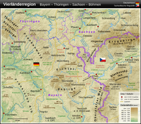
The Eger Basin or Egerer basin (Czech Chebská pánev ) is an after lying approximately in its center Eger (Czech Cheb ) named and 271 square kilometers large natural space in the Czech Republic . Its highest point is the Doubravský vrch (Taubrath mountain near Taubrath , 534 m), its lowest point is the Eger near Kynšperk nad Ohří (Königsberg ad Eger, 431 m).
To the south and east of Schönberg am Kapellenberg , the Egerbecken natural area also extends to the territory of the Free State of Saxony . This only 3.56 km² large portion is described in the Saxon natural area structure as a microgeochore "Schönberger back and pond area".
geology
The Eger Basin is part of the Eger Trench . The sedimentary rock formations of the Eger Basin were deposited during the Young Tertiary and the Older Quaternary between about 2.7 million and 850,000 years ago at the bottom of lakes that have long since silted up. In these vast lakes, the present-day cinder cone of the Kammerbühl was created by volcanism 720,000 years ago . The basement of the basin on which these sediments were deposited consists largely of granitoids from the Bohemian mass .
history
The Eger basin was first settled in the Bronze Age (Bronze Age urn field of Sirmitz, today a district of Franzensbad). From 1835 to 1842 a cave was opened in Untermarxgrün near Oelsnitz / Vogtl. cleared of the rubble of the last ice age , there were further research results on the settlement of the catchment area of the Eger and the basin landscape on the upper reaches. There were pile dwellings in the extensive marshland on the Schladabach and between the Soosbach and the Fonsauerbach. Paul Cartellieri (1807–1881) was the first to explore these moor areas around the spa town of Franzensbad . His son Josef Cartellieri (1849–1909) continued the research with finds that go back to the Stone Age , supplemented by the finds near Dölitz. In 1883 an almost complete skeleton of a Deinotherium (today in the Natural History Museum Vienna ) and skeletal remains of a Mastodon, the forerunner of today's elephants, were found in a limestone mine in Trebendorf .
At the time of the Illyrians , who built castle-like ramparts, cremated their dead and buried them in cemeteries, the Eger basin was densely populated; 70 sites from this time are known.
In the following Hallstatt period (earlier Iron Age) and the La Tène period , the population density fell due to climate change. Local researcher Josef Oskar Steidl secured the finds from this period in the Eger Basin, which are in the Cheb Museum. After the contribution by Ernst Schwarz Language and Settlement in Northeast Bavaria , Nuremberg in 1962, the Narisker tribe also reached western Bohemia .
The Celts , to whom the Eger river owes its name and whose traces of life are modest, were followed by the Germanic tribes of the Hermundurs , the Vandals and Marcomanni , who reached new settlement areas during the migration period .
From around 500 AD, Slavic tribes , probably members of the Sorbs (see: Limes Sorabicus ), settled the area and built a castle complex on the Eger, where the city of Eger, today's Cheb, developed. The archivist Karl Siegl secured the location around 1900, numerous finds and published the research results.
geography
The Eger Basin is bounded by the Elster Mountains and the Ore Mountains in the north, the Falkenau Basin and the Kaiser Forest in the east, the foothills of the Upper Palatinate Forest in the southeast, the Upper Palatinate Forest in the south and the Fichtel Mountains in the west.
literature
- Lorenz Schreiner (Ed.): Eger home district. History of a German landscape in documentations and memories , Amberg in der Oberpfalz 1981, there: Franz Jahnel: Prehistoric settlements in the Egerer Becken , p. 80 ff. With an overview map of the sites, an illustration and further literature references. ibid: Josef Hemmerle : The colonization of the Egerland , pp. 85–91, with a seal from Egerländer Ministeriale Leuchtenberg; Paulsdorf; Notthaid and Hertenberg.
- Anton Stiefl: The lignite and the Eger basin. In: Bohemia. Journal of the history and culture of the Czech lands . Volume 19, 1978, pp. 309-320 ( digitized version ).
Coordinates: 50 ° 7 ′ 0 ″ N , 12 ° 22 ′ 0 ″ E
