Soos
|
Národní přírodní rezervace Soos
|
||
|
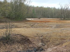
The landscape of the Soos Mineral Bog |
||
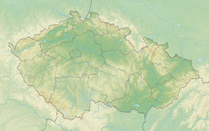
| location | Okres Cheb , Karlovarský kraj , Czech Republic | |
| surface | 221 ha | |
| WDPA ID | 342080 | |
| Geographical location | 50 ° 9 ' N , 12 ° 24' E | |
|
|
||
| Sea level | from 432 m to 442 m | |
| Setup date | November 7, 1964 | |
Soos is an important national nature reserve in the Eger Basin in the Czech Republic . A moor is under protection, which has become internationally known for its natural mofets and mineral springs . The word Soos means moor or swamp in the German dialect of the Egerland.
geography
The Soos Basin is located northeast of the spa town of Františkovy Lázně in the Okres Cheb des Karlovarský kraj in the western Czech Republic . It can be reached via the villages of Třebeň ( Trebendorf ) and Nový Drahov ( Rohr ). The Soos Basin extends over a length of 2200 m and about 1400 m width and covers an area of 221 hectares. To the south, the Soos is bounded by the Vonšovský potok ( Fonsauer Bach ), to the north by the Sázek ( Soosbach ).
geology
The Egergraben consists of various box-shaped break-in structures that can be traced back to intersections of faults. One of these sub-basins is the Soos. In this area of the trench structure, tertiary clays seal the basin and promote waterlogging and the formation of a bog. The pelvic structure is subdivided by two troughs that are separated from each other by a saddle. In the southern hollow is the lake fed by mineral springs, which is joined to the north by the Soos mineral moor. The Soos mineral bog represents the edge facies of the lake.
description
Around 200 mineral springs of different mineralization are known in the Soos nature reserve. The mineralization of the lake water favors the growth of diatoms (diatoms). There are huge diatomite deposits in the basin . The kieselguhr layer is saturated with mineral salts, which bloom when the wet spots fall dry. In the area of the heavily mineralized lake, flora could sometimes develop that otherwise only thrives at the edges of the sea, so-called halophytes . However, in some places the constant oxidation can create an environment that has a toxic effect, so that no plant growth is possible (vitriol water).
These mineralized waters that come to the surface today in the area of the nature reserve (Národní přírodní rezervace Soos) were previously sunk in brewing huts to form salts and used in Soos and Franzensbad. The salts have a high sulphate content. In addition, mud therapy was developed in Soos, in which mud baths made from mineral-rich mud were offered in the baths. Diatomaceous earth and peat were also mined earlier.
In the Soos mineral moor area, mofettes can be observed in many places , natural carbon dioxide degassing that occurs both under water and in the dry. The increased carbon dioxide degassing is related to the young volcanism and is tied to heavily tectonically stressed areas. Here they are in the intersection of the Eger Trench with the Cheb Domázlice Trench. The gas rises in funnels made of sludge. Some of the sludge hoppers are arranged in a line so that it can be assumed that they trace the course of smaller disturbances .
The strong carbon dioxide degassing can also be seen at some of the springs emerging in the bog area. The water brought to the surface at the Kaiserquelle can be referred to as iron-sulfur-hydrogen carbonate-chloride and soda-containing sour wells . The total mineralization is 5.7 g / L at a temperature of 14-18 ° C depending on the season. The increased temperature at shallow extraction depths is due to an increased geothermal gradient (5.5 ° C / 100 m) and the influence of thermal water. The hydrogen sulfide contained in the water of the Kaiserquelle is not brought in by thermal water, but is formed by microbial transformation in the moor. In this process, sulfate is converted into sulfite and later into sulfide and hydrogen sulfide under a strongly reducing environment.
Another source on the edge of the Soos basin in the transition area between bog and peat is the source Vĕra. It is a cold sour well containing lime and soda with a significantly lower mineralization. Dissolved components from the humus ensure strong foam formation.
tourism
The moor is a popular destination for tourists and locals alike. The Nový Drahov train station on the Tršnice – Luby u Chebu railway line is right on the Soos . This is where the museum railway of the Kateřina works begins , which travels through the Soos on certain weekends. There is a museum near the train station that shows the historical development. Paths and boardwalks have been developed for walks through the Soos (entrance opposite the museum). These lead past informative stations.
Web links
- Official website of the Kamenné Vrchy microregion
- Helmholtz Center for Environmental Research GmbH: Signs of magmatic activity observed in Central Europe for the first time . Press release from September 22, 2005 on www.ufz.de (German, Czech)


