
Nový Drahov
| Nový Drahov | |||||
|---|---|---|---|---|---|
|
|||||
| Basic data | |||||
| State : |
|
||||
| Region : | Karlovarský kraj | ||||
| District : | Cheb | ||||
| Municipality : | Třebeň | ||||
| Area : | 250,464 ha | ||||
| Geographic location : | 50 ° 8 ' N , 12 ° 23' E | ||||
| Height: | 440 m nm | ||||
| Residents : | 43 (2011) | ||||
| Postal code : | 351 34 | ||||
| License plate : | K | ||||
| traffic | |||||
| Railway connection: | Tršnice – Luby u Chebu | ||||


Nový Drahov ( German pipe ) is a district of the municipality Třebeň in the Czech Okres Cheb .
geography
Geographical location
The place is located about 1.5 kilometers northwest of Třebeň and 10 kilometers north of Cheb .
Neighboring places
Nový Drahov is connected to the neighboring villages of Žírovice (Sirmitz), Vonšov (Fonsau), Hájek (Soos) and Třebeň (Trebendorf) via country roads.
Culture and sights
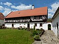
The village is shaped by its historical core. Several four-sided courtyards are grouped around a village pond, where the connecting streets in town also meet. The four-sided courtyards are characteristic Egerland half-timbered houses with a diamond pattern in the half-timbered structure and gates with radial wooden struts. The village ensemble has been part of the list of village monument reserves in the Czech Republic since 1995 . The place, which was originally called Rohr, is the ancestral home of the Rorer family . In the northeast of the village is the Soos nature reserve .

Four-sided courtyard with half-timbered Egerland

Another yard
patio

Village pond in the center of the village


