
Kopanina (Nový Kostel)
| Kopanina | |||||
|---|---|---|---|---|---|
|
|||||
| Basic data | |||||
| State : |
|
||||
| Region : | Karlovarský kraj | ||||
| District : | Cheb | ||||
| Municipality : | Nový Kostel | ||||
| Area : | 902.0224 ha | ||||
| Geographic location : | 50 ° 12 ' N , 12 ° 28' E | ||||
| Residents : | 59 (2011) | ||||
| Postal code : | 351 36 | ||||
| License plate : | K | ||||
| traffic | |||||
| Street: | II / 212 ( Kynšperk nad Ohří - Luby ) | ||||
| administration | |||||
| Website : | www.kamennevrchy.cz/obce/novy-kostel/ | ||||


Kopanina ( German Frauenreuth ) is a district of the municipality Nový Kostel in the Czech Republic .
geography
The place, a row village, is about three kilometers southeast of Nový Kostel in a gently sloping hollow.
Kopanina is also the name of the surrounding area of 9.02 square kilometers.
history
Frauenreuth was first mentioned as Vrowenreuth when the parish boundaries of the church in Schönbach ( Luby u Chebu) were established in 1265, after the church in Frauenreuth was taken over by the Teutonic Order in Eger ( Cheb ) in its administration in 1260 . A yard of the place was the castle Eger erbuntertänig that other farmers had Eger to 1781 60 days a year tensile Robots , a forced labor with draft animals (see also: Bauer legal literature ) afford and interest cereal. The claw tax book of the city of Eger from 1392 names their family names, the muster book the names of the peasants liable for military service.
In 1429 Frawenreuth / Frauenreuth was destroyed and burned down by an army group of the Hussites . They robbed the cattle, took 16 farmers with them as prisoners and devastated 40 villages in the Egerland in months of presence . The eight books and ancient books of the city of Eger (preserved in the city archive of Cheb ) give evidence of the overgrowth and cruelty of this time. It was not until the 16th century that life in the area between Leibitschgrund (Libocky Dul) and Zwodau ( Svatava ) calmed down when lead mining began .
In Frauenreuth and Berg (Horka) there is evidence of lead mining when the city council of Eger was able to grant the right to sample interest. The mining office in Eger was moved to Elbogen in 1840 , to St. Joachimsthal in 1850 and to Karlsbad in 1872 .
During the Reformation , Frauenreuth became Evangelical Lutheran. Evangelical clergy were active from 1564 to 1628. In 1574 an elementary school was founded. The subsequent Counter Reformation and the Thirty Years War brought new misery for the place. The church was struck by lightning in 1666 and poorly received a new spire. A rectory was built in 1724, a new church in 1768 and a schoolhouse in 1773. In the municipal division of 1850, Frauenreuth was assigned the places Berg, Haid (Bor near Frauenreuth), Mühlgrün (Mlynek) and half Nonnengrün (Hluboka near Milhostov ) as the seat of a mayor . In 1904 the community only consisted of Frauenreuth, Mühlgrün and Haid. The parish of Frauenreuth included the places Bruck (Mostek near Klinghart), Berg, Döba (Devin), Haid, Mühlgrün and half Nonnengrün.
After the Munich Agreement , Frauenreuth was added to the German Reich and until 1945 belonged to the district of Eger .
In 1940 an agricultural training school for girls was built; it existed until 1945 (end of World War II ).
Population development
|
|
|
Culture and sights
- St. George's Church, built in 1768
- War memorial for those who died in the First World War
- In the cemetery is the grave of Georg Löw , the general director of the Bohemian Northern Railway .
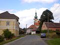
Place view

St. George's Church

War memorial

Georg Loew's tomb


literature
- Lorenz Schreiner (Ed.): Eger home district. History of a German landscape in documentaries and memories, 1981 Amberg in der Oberpfalz, p. 342 ff. Frauenreuth (CSR Frauenreuth, CSSR Kopanina) with a map from 1945 and the house owners at the time with 72 house numbers
- Lorenz Schreiner (ed.): Monuments in the Egerland. Documentation of a German cultural landscape between Bavaria and Bohemia. With the participation of the State Archives in Cheb / Eger under J. Bohac as well as V. Baumgarten, R. Fischer, H. Glassl, E. Hammer, E. Jahn, J. Rak, M. Tietz-Strödel, Heribert Sturm and H.und W. Weiß, 2004, Amberg in der Oberpfalz, pp. 610 to 615 Frauenreuth / Kopanina, with an inventory and illustration of the existing sights
Individual evidence
- ↑ Katastrální území Kopanina. Územně identifikační registr ČR, accessed on March 27, 2016 (Czech).
- ↑ Historický lexikon obcí České republiky - 1869-2015. Český statistický úřad, December 18, 2015, accessed on March 27, 2016 (Czech).
Web links
- Nový Kostel's homepage. Retrieved September 17, 2013 (Czech).