Dilowe
| Dilowe | ||
| Ділове | ||

|
|
|
| Basic data | ||
|---|---|---|
| Oblast : | Zakarpattia Oblast | |
| Rajon : | Rakhiv Raion | |
| Height : | 352 m | |
| Area : | 8.6 km² | |
| Residents : | 2,673 (2006) | |
| Population density : | 311 inhabitants per km² | |
| Postcodes : | 90625 | |
| Area code : | +380 3132 | |
| Geographic location : | 47 ° 56 ' N , 24 ° 11' E | |
| KOATUU : | 2123682501 | |
| Administrative structure : | 3 villages | |
| Address: | вул. Трибушанська 51 90 625 с. Ділове |
|
| Statistical information | ||
|
|
||
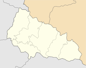
Dilowe ( Ukrainian Ділове ; Russian Деловое Delowoje , Slovak Trebušany , Hungarian Terebesfejérpatak ) is a village in the southeast of the Ukrainian Zakarpattia Oblast on the Romanian border with about 2600 inhabitants (2006).
There has been a marble quarry in the village since 1947 .
Attractions


The village of Carpathian Ukraine gained fame for the 2 m high geodetic monument erected in 1887 , a concrete obelisk which, according to calculations by the Cartographic Institute of the Austro-Hungarian Monarchy , was the geographical center of Europe in connection with the construction of the Rachiw – Sighetu Marmației railway line represents. A plaque on it bears the Latin inscription:
- Locus Perennis Dilicentissime cum libella librationis quae est in Austria et Hungaria confecta cum mensura gradum meridionalium et parallelorum quam Europeum. MDCCCLXXXVII.
East of Dilowe, in the Carpathian Forest Biosphere Reserve , is the 26 m high Jalynskyj waterfall ( Ялинський водоспад ⊙ ).
history
The village, first mentioned in writing in 1615, belonged to the Kingdom of Hungary until the Treaty of Trianon in 1920 , and then to Czechoslovakia until 1939 . From March 1939 until the Russian occupation in 1944 it was Hungarian , then briefly again in Czechoslovakia and from 1946 Soviet . Since 1991 the village belongs to the independent Ukraine . It had the Ukrainian name Trybuschany (Трибушани) until 1947, but was then renamed to its current name.
geography
Dilove located on the upper reaches of the Tisza and the trunk road N 09 in the south of Rajon Rakhiv . The Rajon center of Rakhiv is 18 km north and the Uzhhorod oblast center is 194 km northwest of Dilove. In the village there is a border station on the Sighetu Marmației – Ivano-Frankivsk railway to Romania. The end point of the route, the Romanian town of Sighetu Marmației, is 32 km west of the Tisza. The villages of Kruhlyj ( Круглий ⊙ ) and Chmeliw ( Хмелів ⊙ ) also belong to the district council of Dilowe .
Web links
Individual evidence
- ^ Dilowe on the official website of the Verkhovna Rada ; accessed on January 8, 2015 (Ukrainian)
- ↑ marble quarry Tribushany , accessed on January 9, 2015


