Forest Carpathians
| Forest Carpathians | ||
|---|---|---|
|
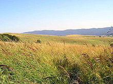
Forest Carpathians, Bieszczady , Poland |
||
| Highest peak | Howerla ( 2060 m ) | |
| location | Ukraine, Poland, Slovakia, Romania | |
| part of | Eastern Carpathians | |
|
|
||
| Coordinates | 48 ° 10 ′ N , 24 ° 30 ′ E | |

The Forest Carpathians ( Slovak Poloniny , Polish Beskidy Lesiste , Ukrainian Лісисті Карпати Lisysti Karpaty ) are a northern part of the Eastern Carpathians .
term
There are several definitions for the term “Forest Carpathians”. These each include the following areas:
- The East Beskids and the Ukrainian Carpathians
- Only the Ukrainian Carpathians ( Українські Карпати )
- Only the East Beskids (although the East Beskids have the additional problem of imprecise delimitation, see under Beskids )
- In the past, and sometimes still today, the entire Eastern Carpathians are referred to in the broader sense as the Forest Carpathians.
Characteristic
Today's geography predominantly uses the first of the above definitions.
The meaning of the Forest Carpathians 1) begins in the west in eastern Slovakia near the city of Bardejov and south-east Poland on the eastern edge of the Sandezer Basin (see under Western Carpathians ) and are mostly in Ukraine . A small area also belongs to Romania, because the Forest Carpathians end at the Prislop Pass ( 1416 m ) on the eastern border of the Maramures region between the Maramures Mountains and the Rodna Mountains in Romania. Its highest point is the Hoverla ( 2061 m ) in Ukraine.
The highest mountain range is the Tschornohora , which joins the Gorgany in the north, the Pokuzko-Bukowinski Karpaty in the northeast, the Grynjawski Hory in the southeast, the Maramures Mountains in the south and the Swydivets in the west .
The name of the mountain points to the partly still original and unused forests of the region, which are characterized by spruce and beech in the lower areas and by firs and larches in the higher areas .
Some of the region's larger rivers have their source in the Forest Carpathians, including the San , the Tisza and the Prut . The Forest Carpathians also include the so-called Polonines .
Folk culture
In or on the edge of the Forest Carpathians there are several open-air museums on the folk culture of the respective region:
In Poland:
- the Museum of Folk Architecture in Sanok
- the wooden churches of the Carpathian region , Poland
In Romania:
In Ukraine:
- the Museum of Folk Architecture and Life in the Carpathian Mountains
- the Museum of Folk Architecture and Life in the Transcarpathian Mountains
- the Old Village Museum in Kolochava
In Slovakia:
- Šarišské múzeum Bardejov
- Museum of Ukrainian Culture , Svidník
natural reserve
With several thousand hectares, the Forest Carpathians are the largest natural forest areas in Central Europe. Some of them have been secured as nature reserves for a long time. In July 2007, UNESCO named large parts of the original beech forests in Slovakia and Ukraine a World Heritage Site . The ten areas cover all or part
- in Slovakia: the Havešová , Vihorlat and Rožok nature reserves and the Poloniny National Park
- in Ukraine: the Carpathian Biosphere Reserve , the Carpathian National Park , the Zacharovaniy Kray National Park and Swydivets .
Main rivers and streams
In Poland ( Bieszczady ):
- San
- Wisłok (White Log)
- Osława (Oslawa)
- Halicz
- Solinka
- Osławica
- Wetlinka
- Czarny
- Jasieńka
- Królówka
- Dołżyca
In Slovakia:
In Ukraine:


