Maramures Mountains
| Maramures Mountains | ||
|---|---|---|
|
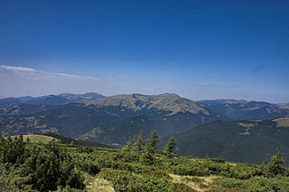
Munții Maramureșului with a view of the Vârful Farcău |
||
| Highest peak | Vârful Farcău ( 1961 m ) | |
| location | Romania , Ukraine | |
| part of | Eastern Carpathians | |
|
|
||
| Coordinates | 47 ° 54 ' N , 24 ° 27' E | |
The Maramures Mountains ( Romanian Munții Maramureșului , Ukrainian Мармароський масив Marmaroskyj Massyw , Polish Karpaty Marmaroskie ; Hungarian Máramarosi-havasok ) is a mountain range of the Eastern Carpathians in northern Romania and a small part of the western part of Ukraine .
The mountain range is located in the Romanian district of Maramureş and in the Rajon Rakhiv in the southeast of the Ukrainian Oblast Zakarpattia . In addition, a small part of the mountain is located in the Ukrainian Oblast Ivano-Frankivsk with the Hnatassja as the southern peak of the Ukrainian Carpathians. The highest elevations include the Vârful Farcău in Romania with 1961 m and the Pip Iwan Maramureș in the Ukraine with 1938 m .
The Munții Maramureșului in Romania have an extension of, according to various sources, 1,334.18 km² or 1,488.50 km².
The area of the mountain range also includes the Romanian nature reserves Vârful Farcău - Lacul Vinderelu - Vârful Mihăilecu on an area of 2,586 hectares, Poiana cu narcise Tomnatec - Sehleanu on 2,588 hectares and the Stâncăriile Sâlhoi - Zâmbroslavele on 2,586 hectares.
Web links
Individual evidence
- ↑ Maramureșului Nature Park, geomorphology on the nature park's website , accessed on January 11, 2015 (English, Romanian).
- ↑ Information on the website of Munții Maramureșului , accessed on March 27, 2019 (Romanian).
- ↑ a b Information from the Monitorul Oficial al Romaniei of August 16, 2016 , accessed on March 27, 2019 (PDF; 28.4 MB; Romanian).

