Tschornohora
| Tschornohora | ||
|---|---|---|
|
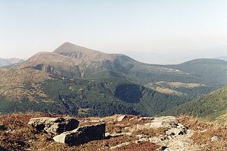
View of the northern part of the Tschornohora with the Hoverla |
||
| Highest peak | Howerla ( 2062 m ) | |
| location | Ukraine | |
| part of | Outer Eastern Carpathians | |
|
|
||
| Coordinates | 48 ° 10 ′ N , 24 ° 30 ′ E | |
| rock | Flysch | |
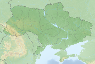
The Tschornohora ( Ukrainian Чорногора ; Russian Черногора Tschernogora , Polish Czarnohora , Czech and Slovak Čornohora / Čornáhora , Hungarian Feketebérc , German Black Mountains ) is the highest mountain range in the Forest Carpathians and Ukraine .
The mountain range is located in the Carpathian Biosphere Reserve in the Outer Eastern Carpathians and connects to the Gorgany to the south .
All two thousand meter peaks in Ukraine are located in the “Black Mountains” ; the Hoverla ( 2062 m ), the Brebeneskul ( 2038 m ), the Pip Iwan ( 2022 m , also Pop Iwan ), the Petros ( 2020 m ), the Hutyn Tomnatyk ( 2016 m ) and the Rebra ( 2001 m ). The Brebeneskul Lake, the highest lake in Ukraine, is also located here .
The main ridge of the massif consisting of flysch rock forms the watershed between the Prut and the Tisza and the border between the Transcarpathian Oblast and the Ivano-Frankivsk Oblast . In the lower elevations of the area there are mainly Hutsuls who are engaged in pasture farming .
Larger towns and tourist centers are Bystrez , Rakhiv , Verkhovyna , Vorokhta and Yasinia .


