Brebeneskul lake
| Brebeneskul lake | ||
|---|---|---|

|
||
| Geographical location |
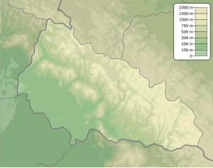
Zakarpattia Oblast , Ukraine |
|
| Data | ||
| Coordinates | 48 ° 6 '8 " N , 24 ° 33' 41" E | |
|
|
||
| Altitude above sea level | 1801 m | |
| surface | 0.61 ha | |
| length | 0.134 km | |
| width | 0.028-0.044 km | |
| Maximum depth | 2.8 m | |
|
particularities |
highest lake in Ukraine |
|
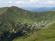
The Brebeneskul Lake (Ukrainian Бребенескул (озеро) , Russian Бребенескуль (озеро) , Polish Brebeneskuł (jezioro) ) is a mountain lake in the Forest Carpathians .
The Brebeneskul lake is located in the " Black Mountains " between the 2038 m high Brebeneskul and the 2016 m high Hutyn Tomnatyk at an altitude of 1801 m and is therefore the highest lake in Ukraine.
The Brebeneskul lake is up to 2.8 m deep and has an oval-shaped surface of 0.61 ha . The lake in the Carpathian Biosphere Reserve is mainly fed by rainwater and groundwater. The water is clear and low mineralized.
The 11 km long Brebeneskul brook flows from the lake and flows over the Hoverla brook to the Tisza . The stream forms small waterfalls, has a catchment area of 30.8 km² and a gradient of 100 m / km.
Web links
Individual evidence
- ↑ Ukrainian Carpathians - Lake Brebeneskul on karpaty.com.ua , accessed on January 12, 2015
- ^ Brebeneskul - high lake; on restinua.com ( memento of the original from September 15, 2012 on WebCite ) Info: The archive link was automatically inserted and not yet checked. Please check the original and archive link according to the instructions and then remove this notice. , accessed January 12, 2015

