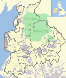
Forest of Bowland

The Forest of Bowland (also known as the Fells of Bowland ) is an area in northeast Lancashire and North Yorkshire in England that consists of low mountains and moors. The part of the name Forest (German: Wald) refers to the use of the area as a hunting area and not to the existence of large forest areas. The Forest of Bowland is an Area of Outstanding Natural Beauty (AONB).
history
Excavations in 2011 uncovered traces of prehistoric settlement in the Forest of Bowland area. Two Roman roads led through the region and places in the Forest of Bowland are also mentioned in the Domesday Book .
1090 the title of Lord of Bowland was created, which was used until 1885 and then fell into disuse. Land ownership has not been associated with the title since 1660, only the privileges of the Lord of Bowland were largely retained thereafter. It wasn't until 2009 that the title was revived.
A separate title is that of the Bowbearer of Bowland , who originally had his own privileges and also played a ceremonial role for the Lord of Bowland and also the English king by carrying a bow in front of him.
landscape
The Mountains (from west to east): Clougha Pike , Grit Fell , Ward's Stone , Wolfhole Crag , White Hill , Whins Brow , Totridge , Parlick ,
Fair Snape Fell , Bleasdale Moors and Hawthornthwaite Fell form a horseshoe open to the west in the Forest of Bowland .
The River Conder , River Hindburn and River Roeburn , which are tributaries to the River Lune , arise in the Forest of Bowland.
The River Dunsop is formed in the Forest of Bowland. The River Dunsop flows over the River Hodder , which also arises in the Forest of Bowland, into the Ribble .
The Stock Reservoir reservoir is located in the Forest of Bowland.
The geographic center of Great Britain at Wolfhole Crag north of Dunsop Bridge is in the Forest of Bowland.
The limestone from the Forest of Bowland area was burned for centuries in many lime kilns still visible today and used as fertilizer and building material.
Web links
- Official Forest of Bowland (AONB) website for information about the history, scenery and events in the Forest of Bowland
- The Lordship of Bowland (PDF; 1.9 MB) Special issue of the magazine Escutcheon Vol. 15 (2010)
Coordinates: 53 ° 57 ′ 0 ″ N , 2 ° 35 ′ 24 ″ W.

