Mendip Hills
The Mendip Hills are a range of karstified limestone ridge in the south-west of England . It is located 25 km south of Bristol in north Somerset .
The hills are bounded to the south and west by the moors called Somerset Levels . In the north they stretch to the Avon River and Chew Valley Lake . Most of them lie in the area of the Mendip district , named after them , whose territory is almost identical to that of the Mendips. However, some of the more northerly heights are in the adjacent districts of North Somerset and Bath and North East Somerset , part of the former County of Avon that was dissolved in 1996. A 200 km² large part of the Mendips has been declared an Area of Outstanding Natural Beauty , whereby the area enjoys the same protection as a national park .
The name Mendip is said to have been derived from the Brythonian term Mened ( Welsh mynydd ), which the Celtic British used to refer to higher moors. The suffix could have originated from a shortening of the Anglo-Saxon word hop for valley.
geology
While most of the Mendips are made of limestone, which comes from the Carboniferous and Jurassic , smaller areas are also formed from sandstone and rocks of volcanic origin. These rocks have their origin in the Devonian (sandstone) and the Silurian (volcanic rock). The volcanic rock is used today in road construction. From the Roman era to the Victorian era , the Mendips were also of economic importance because of the lead deposits there .
In the Mendips there are various features typical of limestone soils such as caves, of which the Wookey Hole Caves , limestone carpets and ravines are particularly worth mentioning . The Cheddar Gorge and the Burrington Combe are also particularly well-known .
ecology
Large areas of the mendips are open alkaline grasslands , which form the basis for the country's enormous wealth of flowering plants and insects . Grazing rabbits , sheep and cattle ensure the preservation of the grassland habitats , which would otherwise turn into a deciduous forest .
Some of the Mendips used to be used intensively for arable farming , especially in the years after the Second World War . However, as the demand for arable land in Great Britain is steadily declining, former arable land is currently being converted back to grassland. The years of use of fertilizers and herbicides due to arable farming still limit the biodiversity in the new grassland areas.
The heathland on the northern heights of the Mendips have recently gained some importance from an ornithological point of view, after a colony of Provence warblers settled there. This bird species, which lives in the western Mendips primarily on Black Down and on Crook Peak , is otherwise only found in low-lying heather areas in Great Britain.
The highest point of the Mendips is the Beacon Batch in Black Down at 325 meters . The Black Down has all the characteristics of a moorland , the lower areas of which are in brackish water , while the higher hills are overgrown with grass and heather . The vegetation on these hills corresponds to that of the pastureland , which covers most of the Mendips.
Stock Hill forests are breeding grounds for the goat milker and long-eared owl . The Waldegrave Pool is an important habitat for dragonflies , including the common emerald dragonfly and the quadruped .
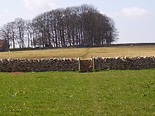
The Mendips are known for their dry stone walls that separate the individual pastures from each other. The walls constructed in a frame structure are very stable, although they were erected without mortar . More and more of these walls are being replaced by barbed wire and cattle fences , as their condition has deteriorated over the years due to a lack of maintenance. The remaining walls are interesting from a botanical point of view because the wall hunger flower , which is endangered in Great Britain , has settled on them .
history
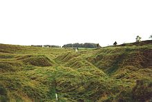
In the Mendips there are many remains from the Stone Age , the Bronze Age and the Iron Age ; including burial mounds , a stone box with incisions and henges , including the Priddy Circles . In particular, the caves ( Aveline's Hole ) of the Cheddar Gorge are known for archaeological finds. Many artifacts were washed into the caves by floods and preserved in the mud there. The most famous find that was made there is the so-called Cheddar Man .
In the last few centuries stones have been quarried in the Mendips, as in the more northerly Cotswolds , which were particularly needed in the cities of Bath and Bristol, but also in some smaller towns in Somerset. The Quarries of Whatley Quarry and Torr Works , which mark about the eastern end of the Mendips, are still the main suppliers for the required in road southwest England stones. A large part of these stones is transported by rail by the Mendip Rail company .
On Pen Hill , near Wells , is the Mendip TV mast. Installed in the 1960s, this mast is the largest in the region.
In 2003 and 2004 the construction of a 300-foot wind turbine near Chewton Mendip was controversial. After long debates, the project was rejected by the responsible district council, which received approval from various local groups and organizations with this decision. The main reason for the rejection was the location of the planned facility directly on the border of the protected Area of Outstanding Natural Beauty . It was feared that such a facility would permanently affect the beautiful and particularly impressive landscape.
Known places
Web links
Coordinates: 51 ° 18 ′ N , 2 ° 44 ′ W


