Lleyn Peninsula
| Lleyn Peninsula | ||
 The Lleyn Peninsula below Anglesey |
||
| Geographical location | ||
|
|
||
| Coordinates | 52 ° 55 ′ N , 4 ° 28 ′ W | |
| Waters 1 | Cardigan Bay | |
| Waters 2 | Caernarfon Bay, Irish Sea | |
| length | 48 km | |
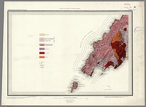
 Geological map (1850) |
||
The Lleyn Peninsula ( Welsh Pen Llŷn [ ɬɨːn ]) is located in north-west Wales in County Gwynedd (formerly Caernarvonshire). It is low and sparsely populated. The coast, warmed by the Gulf Stream, is its main attraction. It has steep cliffs (near Aberdaron ), but also sand dunes and wide beaches (such as Porth Neigwl ). The coast is classified as a Heritage Coast . The interior of the peninsula is dominated by agriculture. The small manor house of yn Rhiw , near Pwllheli , dates from the 16th century and is a museum.
The name (Irish Laighin , same root word as the Irish province of Leinster ) is derived from the Gaelic goddess Nebhain ( Irish female name Nevin - "admirer of the deity"), which indicates the settlement by Irish clans in the 4th and 5th centuries.
Lleyn
The main town of the peninsula is Pwllheli on the south coast, which is a popular sailing, surfing, diving and water sports area, especially Llanbedrog beach . The neighboring town of Abersoch is a port for sailors of all shapes and sizes. Mackerel is fished on the offshore St. Tudwal Islands , and the sea is rich in fish. There are boat tours to the islands. When going around you can see sea caves and sea birds.
Lleyn has been settled since the earliest times. From the Stone Age you can find menhirs such as “Four Crosses”, or those in the cemetery of “Sarn Meyllteyrn” and cup-and-ring markings (Penllech). A reconstructed stone circle is located near Porthmadog . One of the most beautiful Cairn circles is Bryn Cader Faner , near the peninsula. The megalithic systems of Caer-Dyni , "Cefn Isaf", "Cist Cerrig", Llwynfor , "Mynydd Cefn Amwich", "Penarth", Tan y Muriau , Tyn Fron and Ystum Cegid Isaf have been partially destroyed. The better preserved facilities are Bachwen not far from “Bueno's Well”, a holy spring, and Coetan Arthur . The Hillfort "Carn Fodrum" (also C. Fadrun) is located near Llaniestyn. A marked path near T0revor leads up a hill to the “City of Giants”, the Iron Age hill fort “Tre'r Ceiri”. Both places are associated with the legendary King Vortigern . Coastal hiking trails are at Abersoch, Llanbedrog and Pwllheli.
The peninsula is also the site of Paracelsian , an extremely rare monoclinic mineral from the feldspar group.
Bardsey Island
2.9 km southwest of the Uwchmynydd headland is Bardsey Island ( 52 ° 46 ′ N , 4 ° 47 ′ W ) , a sea bird and wildlife sanctuary especially for gray seals . Bardsey was considered a sacred island by the Welsh and is believed to be the burial place of 20,000 saints . In the Middle Ages it was a popular place of pilgrimage that ensured a livelihood for the people in the port of Aberdaron . In some Welsh myths, the island is seen as the mysterious place Avallun (see also Avalon ).
literature
- F. Lynch: The megalithic tombs of north Wales In: Thomas George Eyre Powell et al. (Ed.): Megalithic inquiries in the west of Britain. Liverpool 1969 pp. 107-148
See also
Web links
- Robert Vermaat: Castel Guorthegirn. Vortigern Studies

