
Gwynedd
| Gwynedd Principal Area | |
|---|---|
  |
|
| Administrative headquarters | Caernarfon |
| surface | 2,548 km² |
| Residents | 121,847 (2011) |
| Welsh speakers | 76.1% |
| ISO 3166-2 | GB-GWN |
| ONS code | 00NC |
| Website | www.gwynedd.gov.uk |
| Gwynedd Preserved County (since 1996) administrative county (1974–1996) |
|
|---|---|

|
|
| Districts 1974–1996 |
Aberconwy Anglesey Arfon Dwyfor Meirionnydd |
| Principal Areas since 1996 |
Anglesey Gwynedd |
| Administrative headquarters | Caernarfon |
| surface | 3,262 km² |
| Residents | 187,600 (2009) |
| Population density | 58 people / km² |
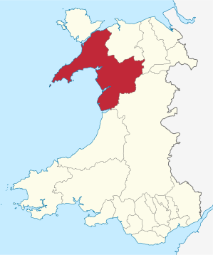
Gwynedd [ ˈgwɪnəð ] is one of the 22 Principal Areas in Wales . Gwynedd is also a Preserved County and a former administrative county , but also includes the island of Anglesey as such . A Preserved County in Wales includes the jurisdiction of the ceremonial offices of Lord Lieutenant and High Sheriff . Gwynedd is also the name of an ancient kingdom in Wales.
The Kingdom of Gwynedd
From the early settlement of the region testify Megalithbauwerke as cromlechs ( stone circles ), such as on the Moel Ty Uchaf , and tumuli ( burial mounds ). The Romans conquered Gwynedd in the 2nd century and built fortifications at Kanovium ( Caerhun ) and Segontium ( Caernarfon ).
After the retreat of the Romans, Wales was divided into four kingdoms in the 5th century. The Kingdom of Gwynedd ( Latin Venedotia ) was one of them, but significantly larger than it is today. According to the tradition, Historia Brittonum ("History of the British", 9th century) of Nennius, the founder was a British chief named Cunedag or Cunedda , to whom the rulers of Gwynedd traced their descent. The new kingdom extended around Snowdon (Snowdonia) and included the island of Anglesey . Seats of power, royal palaces were the Llys, like the excavated Llys Rhosyr. Evidence of Christianization are two Christian grave slabs that are now kept in the Norman Church of St. Mary and Bodfan in Llanaber near Barmouth .
During the Norman conquest from 1066 onwards , the Welsh kingdoms were largely able to maintain their independence. Gwynedd succeeded in this time under Owain Gwynedd , Llywelyn the great and Llywelyn the last to expand his supremacy. With the conquest of Wales by Edward I in 1283, Gwynedd lost its independence.
From administrative county to county
In 1974 a new administrative county was formed from the counties of Anglesey , Caernarfonshire and Merionethshire in north-west Wales, which was named Gwynedd in reference to the old kingdom . Gwynedd was divided into the districts of Aberconwy , Arfon , Dwyfor , Meirionnydd and Anglesey.
As part of a further administrative reform, the two-tier administrative structure was abolished in Wales. Anglesey was raised to its own Principal Area and the Principal Area Gwynedd was formed from the Districts Arfon, Dwyfor and Meirionnydd. The Aberconwy district was added to the Conwy Principal Area . Today's Principal Area Gwynedd has county status. Between 1974 and 1996, Gwynedd is now a Preserved County .
At 2,548 km², Gwynedd is the second largest county in Wales after Powys . In contrast, there is a population of 118,800 (as of 2009) and an average population density of 47 inhabitants per square kilometer. 76.1% of Gwynedd residents said they spoke or at least understood Welsh in 2001 . This gives Gwynedd the highest percentage of Welsh speakers.
Cyngor Gwynedd
The self-government of the area is exercised by Cyngor Gwynedd (English: Gwynedd Council ). There is a general assembly of 75 MPs, who are directly elected in as many constituencies according to the majority vote. Distribution of seats after the election on May 3, 2012:
- Plaid Cymru 37 seats
- Independent 18 seats
- Llais Gwynedd 14 seats
- Labor Party 4 seats
- Liberal Democrats 2 seats
The General Assembly meets six times a year and sets the policy guidelines and the annual budget. There is also a cabinet of 10 members and various committees.
geography


The mainland of Gwynedd is mostly mountainous, with several very ancient mountain ranges of volcanic origin. As a result of intense glacial deformation, sharp ridges have formed. In addition, trough valleys and moraine reservoirs have emerged, z. B. the Tall-y-Llyn on the Cader Idris, which gives the mountain world a high mountain character. Bala Lake, in Welsh Llyn Tegid , in the east is the largest natural body of water in Wales.
The mountain region is protected in the Snowdonia National Park, founded in 1951 . The highest peaks are in the northwest. 14 peaks are higher than 915 meters; the highest, at 1,085 meters, is Snowdon , which gives the national park its name. It is also the highest mountain in England and Wales. A mountain railway leads from Llanberis to the summit. The Cadair Idris , a long ridge further south, reaches a height of 892 m.
The island of Anglesey in the north has no major elevations. It is separated from the mainland by the Menai Strait and accessible via two bridges: the Menai Suspension Bridge built in 1826 and the Britannia Railway Bridge from 1850. The smaller island of Holy Island with the town of Holyhead is connected to Anglesey by the Four Mile Bridge .
The lowland areas on the mainland are limited to the coastal strips, the larger river valleys and the Lleyn Peninsula , which protrudes from Snodownia in a south-westerly direction into the Irish Sea . The largest river in north Gwynedd is the Conwy . The Glaswyn and Mawddach rivers flow west to Cardigan Bay . The Dovey forms part of the Powys border to the south .
The sparse mountain vegetation in the Snowdonia area has two rare types of flowers, the so-called Snowdon lily ( Lloydia serotina ) and the yellow-flowering forest poppy ( Meconopsis cambrica ). The relatively few bird species in the region include ravens , cormorants , kestrels and peregrine falcons . Polecs and pine marten occur in wooded areas.
tourism

In addition to agriculture, tourism is an important economic factor for Gwynedd. Snowdonia National Park alone, which takes up half the county and is home to 26,000 people, attracts millions of visitors each year. It is the third most popular national park in England and Wales. The reason for this is the variety of opportunities to climb, hike, fish or just go on a sightseeing tour.
A tourist center near the park is, for example, Bala with its recreational facilities at Llyn Tegid (English Bala Lake ); Betws-y-Coed is known for its waterfalls, wooded gorges and picturesque bridges; in Blaenau Ffestiniog the disused Llechwedd slate caverns can be visited; Dinas Mawddwy attracts with a textile mill and with Art & Craft Shops; not to forget: Dolgellau below the Cader Idris; the old town of Ffestiniog above the wooded Ffestiniog valley; Llanberis and the massive Dinorwic schist quarries at the foot of Snowdon; also the resorts of Harlech, Barmouth and Aberdovey on Cardigan Bay.
One of the top attractions in Gwynedd is the Ffestiniog Railway . Founded in 1832, it is the oldest active narrow-gauge railway and also the oldest private railway company still in existence in the world.
Edward I. Castles

The Norman King Edward I pursued a consistent policy of conquest towards Wales. In two campaigns in 1277 and 1282/1283 he subjugated the country and at the same time defeated the Prince Llywelyn ap Gruffydd , who had previously supported Simon V de Montfort . With the statute of Rhuddlan , he gave the newly won territory a strict administrative system, unfamiliar to the inhabitants, based on England.
To secure his dominion , Edward built eight new castles in Wales and had numerous others restored or expanded. In Gwynedd he had the castle of Conwy built from 1283 , followed by Caernarfon and Harlech Castle . The last and largest was Beaumaris on Menai Strait on the Isle of Anglesey.
Master builder James of St. George was the leading defensive architect responsible for the medieval structures, all of which were located near the sea. Today the castles as well as the fortified cities that Edward I built are UNESCO World Heritage Sites as monuments of their era .
literature
- Castles in Wales . The Automobile Association; The Wales Tourist Board, 1982, ISBN 0-86145-125-2 .
Web links
- Cyngor Gwynedd Council (Welsh and English)
- Gwynedd High Sheriff's website
- Preserved Counties Act
Individual evidence
- ↑ a b Official population figures 2011 ( MS Excel ; 291 kB)
- ↑ Bernhard Maier : The legend book of the Welsh Celts. The four branches of the Mabinogi . Dtv Munich, April 1999, ISBN 3-423-12628-0 , p. 141, note 72.2.
- ↑ Political Structure ( English ) Gwynedd Council. August 31, 2012. Accessed on July 6, 2013. ( Page no longer available , search in web archives ) Info: The link was automatically marked as defective. Please check the link according to the instructions and then remove this notice.
- ^ The Full Council ( English ) Gwynedd Council. September 7, 2011. Accessed on July 6, 2013. ( Page no longer available , search in web archives ) Info: The link was automatically marked as defective. Please check the link according to the instructions and then remove this notice.
- ↑ The Cabinet ( English ) Gwynedd Council. May 1, 2013. Accessed on July 6, 2013. ( Page no longer available , search in web archives ) Info: The link was automatically marked as defective. Please check the link according to the instructions and then remove this notice.
Anglesey | Blaenau Gwent | Bridgend | Caerphilly | Cardiff | Carmarthenshire | Ceredigion | Conwy | Denbighshire | Flintshire | Gwynedd | Merthyr Tydfil | Monmouthshire | Neath Port Talbot | Newport | Pembrokeshire | Powys | Rhondda Cynon Taf | Swansea | Torfaen | Vale of Glamorgan | Wrexham
Clwyd | Dyfed | Gwent | Gwynedd | Powys | Mid Glamorgan | South Glamorgan | West Glamorgan
Coordinates: 52 ° 49 ′ N , 4 ° 1 ′ W