Merionethshire
| Merionethshire | ||
|---|---|---|
|
|

|
|
| Capital | Dolgellau | |
| surface | 1,709 km² | |
| population | 39,007 (1961) | |
| Population density | 23 inhabitants / km² | |
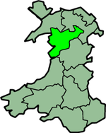
Merionethshire (Welsh: Sir Feirionnydd ) is one of the thirteen traditional counties and a former administrative county of Wales . The historic capital is the city of Dolgellau .
geography
The county lies on Cardigan Bay and borders Caernarfonshire , Denbighshire , Montgomeryshire and Cardiganshire on the land . The landscape is mountainous and is shaped by the Snowdonia National Park . The highest peaks are the Aran Fawddwy (905 m) and the Cadair Idris (893 m). The Dwyryd , Mawddach and Dyfi are the main rivers. Important places besides Dolgellau are Aberdyfi , Bala , Barmouth , Blaenau Ffestiniog , Corwen , Ffestiniog , Harlech and Tywyn .
In 1961 the county had 39,007 inhabitants on an area of 1,709 km².
Administrative history
Merionethshire was an administrative county until 1974, when it was divided between the Meirionnydd District of Gwynedd and the Glyndŵr District of Clwyd . Since the administrative reform of 1996, the area of Merionethshire extends over the Unitary Authorities Gwynedd and Denbighshire .
Individual evidence
- ↑ rororo Duden-Lexikon 1966
