
Morne Mountains
| Morne Mountains | ||
|---|---|---|
 View of the Mountains of Morne |
||
| Highest peak | Slieve Donard ( 849 m ASL ) | |
| location | Northern Ireland | |
|
||
| Coordinates | 54 ° 10 ′ N , 6 ° 5 ′ W | |

The Morne Mountains (also Mountains of Morne ; Irish Na Beanna Boirche ) are a granite mountain range around 50 km south of the Northern Irish capital Belfast between Newry and Newcastle in the Barony of Morne (Irish Múrna ) in County Down . The most famous peak is the Slieve Donard , at 849 meters the highest mountain in Northern Ireland. The area is classified as an Area of Outstanding Natural Beauty , and it is here that Northern Ireland's first national park will be created.
The mountains are a popular local recreation area and are visited by many tourists, hikers, mountain bikers and mountaineers. Following a fundraising drive in 1993, the National Trust acquired an area of 5.26 km² in the mountains. In this are the Slieve Donard and the neighboring Slieve Commedagh , with 767 m the second highest mountain in the area. One of the sights is the Morne Wall . This 35 km long dry stone wall was built between 1904 and 1922 and surrounds the headwaters and the reservoirs that serve to supply the city of Belfast with drinking water . This wall was originally intended to keep sheep and cattle out of the drinking water area.
photos

The Morne Wall
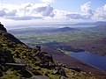
Silent Valley Reservoir and Carlingford Lough

Slieve Donard and Analong Wood

Mountain panorama

View towards Kilkeel and the Irish Sea


Web links
- Official website of the Mountains of Morne
- Private website with information about the Mountains of Morne ( Memento of March 3, 2001 in the Internet Archive )

England
Arnside and Silverdale | Blackdown Hills | Cannock Chase AONB | Chichester Harbor | Chiltern Hills | Cornwall AONB | Bodmin Moor | Cotswolds | Cranborne Chase and West Wiltshire Downs | Dedham Vale | Dorset AONB | East Devon AONB | East Hampshire AONB | Forest of Bowland | High Weald | Howardian Hills | Isle of Wight AONB | Isles of Scilly | Kent Downs | Lincolnshire Wolds | Malvern Hills | Mendip Hills | Nidderdale | Norfolk Coast | North Devon AONB | North Pennines | Northumberland Coast | North Wessex Downs | Quantock Hills | Shropshire Hills | Solway Coast | South Devon | South Hampshire Coast | Suffolk Coast and Heaths | Surrey Hills | South Downs | Tamar Valley | Wye Valley
Wales
Anglesey | Clwydian Range | Moel Famau | Gower Peninsula | Lleyn Peninsula | Wye Valley
Northern Ireland
Antrim Coast and Glens | Binevenagh | Causeway Coast | Lagan Valley | Morne Mountains | Ring of Gullion | Sperrin Mountains | Strangford and Lecale