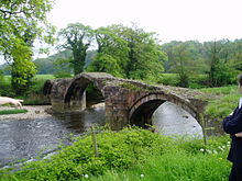
River Hodder
| River Hodder | ||
|
The River Hodder from the Burholme Bridge |
||
| Data | ||
| location | Lancashire , England | |
| River system | River Ribble | |
| Drain over | River Ribble → Irish Sea | |
| River basin district | North West | |
| origin | on the north side of White Hill 54 ° 2 ′ 23 " N , 2 ° 28 ′ 53" W. |
|
| Source height | 400 m ASL | |
| muzzle | in the Ribble south of Great Mitton Coordinates: 53 ° 50 ′ 20 " N , 2 ° 26 ′ 31" W 53 ° 50 ′ 20 " N , 2 ° 26 ′ 31" W |
|
| Mouth height | 41 m ASL | |
| Height difference | 359 m
|
|
| Right tributaries | Croasdale Brook , River Dunsop , River Loud , | |
| Reservoirs flowed through | Stocks reservoir | |
| Communities | Slaidburn , Newton-in-Bowland , Dunsop Bridge , Great Mitton | |
The River Hodder is a river in the Forest of Bowland , Lancashire , England . The River Hodder arises on the northern slope of White Hill from the confluence of the Red Syke and other unnamed smaller drains. Shortly after its formation, smaller likewise unnamed outflows from a plateau formed by Catlow Fell and Great Harlow meet the River Hodder.
In its course, which runs completely in the Forest of Bowland until shortly before its mouth, the River Hodder drains large parts of the Forest of Bowland in cooperation with its tributaries.
The River Hodder flows generally south through Stocks Reservoir and then turns temporarily west between Newton-in-Bowland and Dunsop Bridge and then resumes its southerly direction.
Before the River Hodder joins the Ribble south of Great Mitton , it passes the Lower Hodder Bridge ( 53 ° 51 ′ 54.8 ″ N , 2 ° 27 ′ 42 ″ W ), the historic border between Lancashire and the West Riding of Yorkshire marked.


