
Vardar
|
Vardar Вардар, Axiós (Αξιός) |
||
 Stone bridge over the Vardar (Axios) in Skopje |
||
| Data | ||
| location | North Macedonia , Greece | |
| River system | Vardar | |
| source |
Šar Planina , in the village of Vrutok near Gostivar 41 ° 45 ′ 33 ″ N , 20 ° 49 ′ 55 ″ E |
|
| Source height | 683 m | |
| muzzle |
Thermaic Gulf ( Aegean Sea ) Coordinates: 40 ° 30 ′ 49 " N , 22 ° 42 ′ 51" E 40 ° 30 ′ 49 " N , 22 ° 42 ′ 51" E |
|
| Mouth height | 0 m | |
| Height difference | 683 m | |
| Bottom slope | 1.8 ‰ | |
| length | 388 km | |
| Catchment area | 24,438 km² | |
| Left tributaries | Pčinja , Svetinikolska , Bregalnica , Lepenac | |
| Right tributaries | Treska , Crna Reka , Babuna, Gorgopis, Platanopotamos | |
| Big cities | Skopje , Gostivar , Tetovo | |
| Medium-sized cities | Gevgelija , Veles | |
| Small towns | Axioupolis , Prochoma | |
| Residents in the catchment area | 1.96 million | |
 Course of the Vardar River |
||
The Vardar (also Wardar ; Macedonian Вардар ; Greek Βαρδάρης Vardáris , today mostly Axiós Αξιός ; Albanian also Vardari ) is a river in southeastern Europe of about 388 km in length. The majority of 301 of the 388 km runs in the territory of North Macedonia , the remaining 87 km runs in the territory of the Central Macedonia region in Greece .
The catchment area of the Vardar (Axios) covers approx. 25,000 km², of which 20,535 km² (82.59%) are in North Macedonia. Greece includes 2994 km² of the catchment area (12.25%), Serbia includes 1149 km² (4.71%) and Bulgaria 111 km² (0.45%).
course
The Vardar has its source in northwestern North Macedonia near the city of Gostivar and initially flows north. Shortly before the border with Kosovo , it turns first to the east, later to the south-east, passing the north Macedonian capital Skopje . The Vardar then maintains this direction up to the town of Valandovo. During the passage from Valandovo to the west, the Vardar swings to the south-southeast. The last city on North Macedonian territory is Gevgelija . The Vardar flows south of Gevgelija near the town of Idomeni on Greek territory.
The river, now called Axios, continues its direction of flow to the south-southeast and is the first Greek city to pass the village of Axioupolis. In Greek territory 49 km south of the border, the Axios is dammed by the Ellis Dam. There its water is taken for irrigation purposes. The Ellis Dam is closed from April to September each year. The Axios flows into the Aegean Sea west of Chalastra in the immediate vicinity of the city of Thessaloniki . In 1934, the Axios was channeled on Greek territory from the village of Polykastro in Kilkis Prefecture. The aim of the canalization, in addition to obtaining water for the purpose of irrigation in agriculture, was to slow down the silting of the Thermaic Gulf caused by the sediments of the Axios. With increasing or unchanged silting up of the thermal gulf, the access to the port of Thessaloniki would have been endangered. As part of these water management construction projects, the Axios estuary, originally west of the mouth of the Gallikos River near Kalochori, was moved to its current position south of Chalastra.

River Vardar near the village of Nogaevci, North Macedonia

River Vardar near the city of Veles, North Macedonia
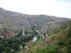
River Vardar in the Vardar Valley, North Macedonia

Vardar Bridge in Skopje around 1909


Water flow
The Vardar had an average annual runoff in Skopje of 48 to 76 m³ per second between 1970 and 1985. At the North Macedonian-Greek border, discharge rates of 100 to 225 m³ per second were measured in the same period. From 1985 onwards, the flow rate of the Vardar (Axios) sank significantly at both measuring points. In 1994 the mean annual flow in both Skopje and on the North Macedonian-Greek border was still 30 m³ per second. This intensive water extraction, the flooding of fertilizer residues as well as the sewage with heavy metals and other pollutants from increasing industrialization significantly pollute the Vardar (Axios).
Traffic and historical importance
The Vardar valley together with the valley of the Southern Morava (geologically referred to as the Morava-Vardar furrow ) forms the most important (shortest and therefore most economical) north-south connection in south-east Europe, the so-called Corridor 10 in the European transport network of the Pan-European Transport Corridors . The railway line (Belgrade – Skopje – Thessaloniki) and the north-south motorway run there . To the east of the point where the Vardar (Axios) crosses the North Macedonian-Greek border is the Bogorodica / Evzoni motorway border crossing . The Greek motorway 1 leads along the Axiostal to Thessaloniki, but a few kilometers east of the river. The railway line Skopje – Thessaloniki crosses the border between North Macedonia and Greece parallel to the river Vardar (Axios) at Gevgelija / Idomeni. The oil pipeline from Thessaloniki to Skopje also runs parallel to the Axios River.
The historical names Vardar Republic or Vardar Macedonia refer to the river Vardar as the namesake. These designations were also discussed as a compromise in the name dispute between North Macedonia and Greece. In any case, Vardar Macedonia refers to the northernmost part of the historical region of Macedonia or Macedonia.
Trivia
- The popular song Jugoslavijo , also called Od Vardara pa do Triglava (From the Vardar River to the Triglav Mountain) because of its first stanza , was considered the unofficial anthem of Yugoslavia . It outlines the borders and evokes the unity of the country at that time.
literature
- Internationally Shared Surface Water Bodies in the Balkan Region. Transboundary River Sub-basins. Vardar / Axios River Sub-basin
- Th. Christodoulou, IL Leontiadis, A. Morfis, BR Payne, S. Tzimourtas: Isotope hydrology study of the Axios River plain in northern Greece. Journal of Hydrology . 146: 391-404 (1993).
- E. Kampa, V. Artemiadou, M. Lazaridou-Dimitriadou: Ecological quality of the River Axios (N. Greece) during spring and summer . 1997. Belg. J. Zool. 130 Supplement 1 (2000): 21-27.