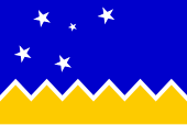
Chilean Antarctic Territory

|
|

|
|
| Antártica municipality | |
| Capital | Puerto Covadonga |
|
surface |
- 1,250,257 km² |
|
Residents - Censo 2002 |
- 130 inhabitants |
The Chilean Antarctic Territory ( Spanish Territorio Antártico Chileno ) is a part of the Antarctic claimed by Chile . In the Chilean administrative structure, the area is congruent with the municipality of Antártica , which is administratively counted as the southernmost province of Chile, the province of Antártica Chilena on the Strait of Magellan , which in turn belongs to the XII. Region belongs. Chile's claim to territory in the Antarctic is not internationally recognized.
Location, status and infrastructure
The territory extends from 53 ° to 90 ° west longitude . The area between 20 ° and 80 ° west longitude is also claimed by Great Britain , the sector between 25 ° and 74 ° west longitude also by Argentina . The heartland of the territory claimed by Chile, especially the Antarctic Peninsula , which is the continuation of the Andean land massif on the southern continent and is around 1000 kilometers from Cape Horn , the southern tip of South America belonging to Chile, thus also belongs to the Argentine and British Antarctic territory .
Chile bases its claims on historical continuity ( legal succession of Spanish claims that go back to the Treaty of Tordesillas ), on its location as a neighboring country, on the administrative and infrastructural facilities it has created in this area and on the scientific evidence that the in Chile as the O'Higgins Peninsula called the Antarctic land and glacier mass is the geological continuation of the Andes .
With the Decreto Supremo No. In 1747 of November 6, 1940, Chile declared its claims to the defined Antarctic sector. With the entry into force of the Antarctic Treaty on June 23, 1961, the assertion of the claim was temporarily suspended. On July 11, 1961, the La Antártica commune , Departamento de Magallanes, was proclaimed.
The territory is administratively subject to the XII. Region based in Punta Arenas . Chile operates several beacons in the Antarctic Territory as well as post offices in the Punta Arenas postal district. The Chilean Air Force also maintains an air base on Isla Rey Jorge .
Antártica municipality
The municipality of Antártica , founded on July 11, 1961, is the only municipality in Chile that does not include its own municipality; it is administered by the municipality and municipality of Cabo de Hornos (formerly Navarino , seat of government in Puerto Williams ). The community of these two municipalities is called Cabo de Hornos y Antártica .
The commune is divided into two census districts, Piloto Pardo and Tierra O'Higgins . The official capital is Puerto Covadonga (civil name of the Bernardo O'Higgins station ); the only noteworthy actual civil settlement is Villa Las Estrellas on Isla Rey Jorge (King George Island) with 80 Chilean residents permanently living there and various civil infrastructure facilities (school, hospital, shops, etc.).
List of Chilean bases by location
- Base Presidente Eduardo Frei Montalva (opened 1969; permanently occupied)
- Base Professor Julio Escudero (opened in 1995; permanently occupied)
- Refugio Collins (opened in 2006)
- Refugio Julio Ripamonti (opened in 1982; only occupied in summer)
- Refugio Luis Risopatrón (opened in 1949; only occupied in summer)
- Base Naval Capitán Arturo Prat (opened 1947; permanently manned)
- Base Doctor Guillermo Mann Fischer (formerly Campamento Shirreff; opened 1991; only occupied in summer)
- Base Presidente Pedro Aguirre Cerda (opened 1955; abandoned in 1967 after being destroyed by a volcanic eruption)
- Refugio Cabo Héctor Gutiérrez Vargas (opened 1956; abandoned in 1967 after being destroyed by a volcanic eruption)
- Refugio Caleta Telefon (opened 1958; abandoned in 1967 after a volcanic eruption)
- Base General Bernardo O'Higgins (opened 1948; permanently manned)
- Refugio Abrazo de Maipú (first opened in 1967 by Argentina and later destroyed; reopened in 2004; closed since 2010 for security reasons)
- Refugio General Jorge Boonen Rivera (formerly General Ramón Cañas Montalva; opened in 1953 by Great Britain as Station V - View Point ; transferred to Chile in 1996; only occupied in summer)
- Refugio Doctor Guillermo Mann (opened 1973; now closed)
- Base Presidente Gabriel González Videla (opened 1951; only occupied in summer)
- Base Yelcho (opened in 1962; only occupied in summer)
- Base Teniente Luis Carvajal Villarroel (opened in 1961 by Great Britain as Base T - Adelaide Island ; transferred to Chile in 1984; only occupied in summer)
- Refugio Comodoro Guesalaga (opened in 1963; now closed)
- Base Glaciar Unión (opened in 2014; only occupied in summer)
- Base de Verano Antonio Huneeus Gana (opened in 1997; dissolved in 2013 and relocated to Base Glaciar Unión )
- Estación Polar Teniente Arturo Parodi Alister (opened in 1999; dissolved in 2013 and relocated to Base Glaciar Unión )
See also
Coordinates: 75 ° 0 ′ S , 70 ° 0 ′ W


