Antarctic Peninsula
| Antarctic Peninsula | ||
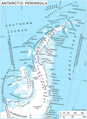
 Map of the Antarctic Peninsula |
||
| Geographical location | ||
|
|
||
| Coordinates | 70 ° S , 65 ° W | |
| location | West Antarctica | |
| Waters 1 | Weddell Sea | |
| Waters 2 | Bellingshausen lake | |
| length | 1 200 km | |
 The Booth Island (left) and Mount Scott on the west side of the Antarctic Peninsula |
||
The Antarctic Peninsula is a peninsula on the Antarctic continent ( Antarctica ) that protrudes beyond the Arctic Circle . Its tip, which lies opposite the southern end of South America , is the point of Antarctica furthest from the South Pole . The peninsula has a length of about 1200 km.
designation
For a long time the British name Grahamland and the American name Palmerland competed with each other. Today graham land applies to the part of the peninsula north of a line between Cape Jeremy and Cape Agassiz and Palmerland to the part south of this line. In addition, there are the Spanish terms San Martín Peninsula (in Argentina) for Graham Land and O'Higgins Peninsula (in Chile) for the entire peninsula.
Geography and climate
The peninsula is mountainous to a high degree and rises up to 2800 m . This mountain range is considered to be a continuation of the South American Andes . Since the peninsula has the mildest climate in Antarctica (temperatures in summer on the coast 0 to 3 ° C , in winter -10 to -20 ° C), the highest concentration of research stations can be found here and on the many nearby islands Antarctic continent. Hope Bay ( ⊙ ) on the east coast of the Trinity Peninsula is the northernmost point of the peninsula.
Southern border
Until 2009, the southern boundary of the Antarctic Peninsula was generally a line from Cape Adams (which roughly marks the edge of the Filchner-Ronne Ice Shelf ) to a point on the English coast at 73 ° 24 ′ S , 72 ° 0 ′ W , opposite the Eklund Islands , viewed (Chile sets the southern limit of the Tierra de O'Higgins further south, at 76 ° 0 ′ S , 66 ° 0 ′ W ). In 2009 the British redefined the southern border to take into account the knowledge gained since the middle of the 20th century about the coastline hidden by the ice shelf, from the Rydberg Peninsula at 73 ° 0 ′ S , 80 ° 0 ′ W up to the pivot line (grounding line) of the Evans-river of ice at about 76 ° 34 ' S , 75 ° 0' W . This also shifts the southern border of the Palmerland accordingly, whereby geographical objects between the two southern borders lie in the Palmerland according to the British view, and in the Ellsworthland according to the US - which adheres to the conventional southern border .
Political Inclusion
The peninsula is claimed equally by Argentina , Chile and Great Britain and incorporated into their respective Antarctic territories, which completely overlap in the area of the peninsula. However, like the rest of Antarctica, it falls under the Antarctic Treaty of 1961, with which the states committed themselves to suspending their respective claims.
See also
- Argentine Antarctic Territory
- British Antarctic Territory
- Chilean Antarctic Territory
- Political status of the Antarctic
Individual evidence
- ↑ a b c d Antarctic Peninsula in the Geographic Names Information System of the United States Geological Survey , accessed November 2, 2017
- ↑ a b c d Antarctic Peninsula (GBR) in the SCAR Composite Gazetteer of Antarctica , accessed on November 2, 2017
- ↑ San Martín, tierra de (ARG) in the SCAR Composite Gazetteer of Antarctica , accessed on November 2, 2017
- ↑ a b Tierra de O'Higgins, Península (CHL) in the SCAR Composite Gazetteer of Antarctica , accessed on November 2, 2017
- ↑ Palmer Land (GBR) in the SCAR Composite Gazetteer of Antarctica , accessed on November 2, 2017
Web links
