Fallières coast
| Fallières coast | ||
|---|---|---|
|
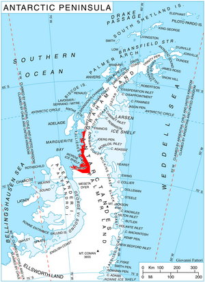
Location of the Fallières coast on the Antarctic Peninsula
|
||
|
|
||
| location | Grahamland , Antarctic Peninsula | |
| Waters | Marguerite Bay | |
| From |
Bourgeois Fjord 67 ° 40 ′ 0 ″ S , 67 ° 5 ′ 0 ″ W |
|
| To |
Cape Jeremy 69 ° 24 ′ 0 ″ S , 68 ° 51 ′ 0 ″ W. |
|
Coordinates: 68 ° 30 ′ S , 67 ° 0 ′ W
The Fallières coast is the part of the west coast of Graham Land on the Antarctic Peninsula, lying on Marguerite Bay . The coast stretches from the entrance of the Bourgeois Fjord to Cape Jeremy at the beginning of George VI Sound . The Loubet coast connects to the north and the Rymill coast to the south .
Its northern part was discovered and mapped on January 15, 1909 by the French Antarctic Expedition 1908-1910 , whose leader Jean-Baptiste Charcot named the area after the French President Armand Fallières . In the southern summer of 1936/37 the coastline was completely surveyed by the British Grahamland Expedition under the direction of John Rymill .
Web links
- Fallières Coast in the Geographic Names Information System of the United States Geological Survey (English)
- Fallières Coast on geographic.org
Individual evidence
- ^ John Stewart: Antarctica - An Encyclopedia . Vol. 1, McFarland & Co., Jefferson and London 2011, ISBN 978-0-7864-3590-6 , p. 536 (English)

