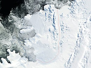
George VI Sound
| George VI Sound | ||
|---|---|---|
| George VI Sound (red line) | ||
| Connects waters | Marguerite Bay | |
| with water | Ronne Entrance | |
| Separates land mass | Alexander I Island | |
| of land mass | Palmerland , Antarctic Peninsula | |
| Data | ||
| Geographical location | 71 ° 0 ′ S , 68 ° 0 ′ W | |
|
|
||
| length | 480 km | |
| Smallest width | 24 km | |
The George VI Sound is an icy, fjord-like strait about 480 km in length, which separates Alexander I Island from the west coast of the Palmerland on the Antarctic Peninsula . In the northern part, the entire Rymill coast runs along its west coast, and then part of the English coast to the south and west . The width of the sound varies between 24 and 64 km. The sound is largely occupied by the George VI Ice Shelf .
It was discovered by the American polar explorer Lincoln Ellsworth during an overflight in 1935. It was explored by participants in the British Graham Land Expedition (1934-1937) led by the Australian polar explorer John Rymill and in 1940 during the United States Antarctic Service Expedition (1939 -1941). Rymill named the sound after the British monarch George VI. (1895-1952).
Web links
- George VI Sound in the Geographic Names Information System of the United States Geological Survey (English)
- George VI Sound on geographic.org (English)

