Bowman coast
| Bowman coast | |
|---|---|
| location | Grahamland , Antarctic Peninsula |
| Waters | Weddell Sea |
| From |
Cape Northrop 67 ° 24 ′ 0 ″ S , 65 ° 16 ′ 0 ″ W. |
| To |
Cape Agassiz 68 ° 29 ′ 0 ″ S , 62 ° 56 ′ 0 ″ W. |
Coordinates: 68 ° S , 65 ° W
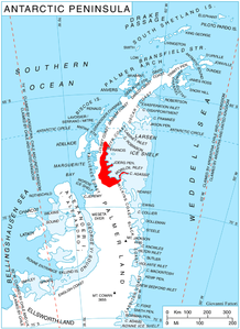
The Bowman Coast is a stretch of coast in the east of the Antarctic Peninsula that lies between Cape Northrop and Cape Agassiz . The Foyn Coast joins in the north and the Wilkins Coast in the south .
It was discovered by the Australian polar explorer Hubert Wilkins on his flight on December 20, 1928. Wilkins named the coast after the American geographer Isaiah Bowman (1878–1950), Executive Director of the American Geographical Society from 1919 to 1935.
Web links
- Bowman Coast in the Geographic Names Information System of the United States Geological Survey (English)
- Bowman Coast on geographic.org (English)
