Greenwich Island
| Greenwich Island | ||
|---|---|---|
| View from Livingston Island to Greenwich Island. In the foreground Half Moon Island in Moon Bay. | ||
| Waters | Southern ocean | |
| Archipelago | South Shetland Islands | |
| Geographical location | 62 ° 31 ′ S , 59 ° 47 ′ W | |
|
|
||
| length | 24 km | |
| width | 10 km | |
| surface | 173.8 km² | |
| Highest elevation |
Momchil Peak 625 m |
|
| Residents | 9 station staff in winter <1 inhabitant / km² |
|
| main place | ( Arturo Prat Station ) | |
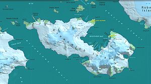
| Map of Greenwich Island | ||
Greenwich Island (historical names: Sartorius Island , Berezina Island ) is an island in the South Shetland Islands . It has a length of 24 km, a width between 0.8 and 10 km and an area of 173.8 km². It is located in the southern group of the archipelago between Robert Island in the northeast and Livingston Island in the southwest and is separated from these by the English and McFarlane Straits. The highest point of the heavily glaciated island is the 625 m high Momchil Peak .
The Chilean research station Arturo Prat and the Ecuadorian station Pedro Vicente Maldonado are located on Discovery Bay in the northeast of the island.
The name Greenwich Island dates back to 1821 or earlier and has become the common name of the island.
cards
- LL Ivanov et al .: Antarctica: Livingston Island and Greenwich Island, South Shetland Islands (from English Strait to Morton Strait, with illustrations and ice-cover distribution). Topographic map on a scale of 1: 100,000, Antarctic Place-names Commission of Bulgaria, Sofia 2005.
- LL Ivanov: Antarctica: Livingston Island and Greenwich, Robert, Snow and Smith Islands . Topographic map on a scale of 1: 120,000. Manfred Wörner Foundation, Troyan, 2009. ISBN 978-954-92032-6-4
Web links
Commons : Greenwich Island - Collection of pictures, videos and audio files
Individual evidence
- ↑ UNEP Islands (English)


