Livingston Island
| Livingston Island | ||
|---|---|---|
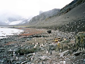
| The Liverpool Beach on the south coast of Livingston Island | ||
| Waters | Southern Ocean (between Drake and Bransfield Straits ) | |
| Archipelago | South Shetland Islands | |
| Geographical location | 62 ° 36 ′ S , 60 ° 30 ′ W | |
|
|
||
| length | 73 km | |
| width | 35 km | |
| surface | 974 km² | |
| Highest elevation |
Mount Friesland 1700 m |
|
| Livingston Island Map | ||
The Livingston Island ( English Livingston Island ) is the second largest island of the South Shetland Islands off the West Antarctic .
The island is 73 km long and 34 km wide, the area is 974 km². It lies west of neighboring Greenwich Island and north of Deception Island . Livingston's highest point is Mount Friesland in the Tangra Mountains at 1,700 meters . The temperatures in summer hardly exceed 3 ° C, in winter it can get down to –14 ° C.
The island was discovered on February 19, 1819 by the English navigator William Smith and soon afterwards was visited by seal hunters .
Today there are some Antarctic research stations on Livingston , including the Spanish Juan Carlos I station and the Bulgarian St. Kliment Ohridski station . The island is also a stop for visiting cruise ships .
The mountain saddle Wörner Gap here was named after the German politician Manfred Wörner .
cards
- LL Ivanov: Antarctica: Livingston Island and Greenwich, Robert, Snow and Smith Islands . Topographic map on a scale of 1: 120,000. Manfred Wörner Foundation, Troyan, 2009, ISBN 978-954-92032-6-4
- LL Ivanov. Antarctica: Livingston Island and Smith Island . Scale 1: 100000 topographic map. Manfred Wörner Foundation, 2017. ISBN 978-619-90008-3-0
Web links
- Ivanov, L. General Geography and History of Livingston Island. In: Bulgarian Antarctic Research: A Synthesis . Eds. C. Pimpirev and N. Chipev. Sofia: St. Kliment Ohridski University Press, 2015. pp. 17-28. ISBN 978-954-07-3939-7
- Ivanov, LL Livingston Island : Tangra Mountains, Komini Peak, west slope new rock route; Lyaskovets Peak, first ascent; Zograf Peak, first ascent; Vidin Heights, Melnik Peak, Melnik Ridge, first ascent. The American Alpine Journal , 2005. pp. 312-315.
- Gildea, D. Mountaineering in Antarctica: complete guide: Travel guide. Primento and Editions Nevicata, 2015. ISBN 978-2-51103-136-0


