
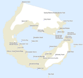
Deception Island
| Deception Island | ||
|---|---|---|
_41.jpg) |
||
| Waters | Bransfield Street | |
| Archipelago | South Shetland Islands | |
| Geographical location | 62 ° 57 ′ S , 60 ° 38 ′ W | |
|
||
| length | 14.4 km | |
| width | 12.2 km | |
| surface | 98.5 km² | |
| Highest elevation |
Mount Pond 539 m |
|
| Residents | uninhabited | |
| main place | (Base Decepción) | |

Deception Island is one of the South Shetland Islands , a sub-Antarctic archipelago . The island is the summit area of an active volcano that towers about 1500 m from the seabed ; the last eruption so far occurred in 1970.
geography
The island, about 20 km south of Livingston Island in the Bransfield Strait , consists of the edge of a caldera flooded by the sea and has a diameter of 13 to 14 km. Ships can reach the crater lake, Port Foster , through a strait less than 400 m wide in the southeast of the island, called Neptune's bellows . Due to volcanic activity, the water temperature there is around 10 ° C. The highest peaks on the island are Mount Kirkwood with around 460 m and Mount Pond , which is 539 m high.
Deception Island is a geologically very young island that was probably only formed during the last 150,000 years. About 10,000 years ago a volcanic eruption of magnitude 6 on the VEI scale , in which material with an estimated volume of around 30 km³ was ejected, caused the caldera to collapse. The volcano is still considered active and unpredictable. Measurements towards the end of the 20th century showed that the bottom of the caldera, which is around 165 m below sea level, is rising at a rate of more than 30 cm per year, which could indicate a resurgence of volcanic activity.
history
The island was first sighted on January 29, 1820 by William Smith and Edward Bransfield , but could not be entered due to bad weather. Probably the first to sail the American sealer Hero under his captain Nathaniel Palmer into the natural harbor later known as Port Foster. This is by Henry Foster named the 1829 geophysical as head of the first scientific expedition to Antarctica measurements with the reversible pendulum in the designated pursuant to this event Pendulum Cove (English for shuttle bay performed).

In 1842, a volcanic eruption was first observed directly on the island. Until the eruption in 1967, which ushered in a period of greater activity, volcanism did not affect the activities of whalers and sealers or explorers to any great extent. During the outbreak of 1967, the English research station on Whalers Bay and the Chilean research stations Pedro Aguirre Cerda and Gutiérrez Vargas on Pendulum Cove were badly damaged. The attempt by the British to rebuild their station in 1969 was ended by another eruption on the western side of Mount Pond on February 21, which resulted in the station's final abandonment two days later.
From 1912 to 1931, Whalers Bay was home to the world's southernmost liquor factory operated by the Norwegian Hvalfangerselskabet Hektor A / S. Most of the time there is a cemetery with 35 graves, which was largely buried during the volcanic eruptions of the 1960s.
On November 16, 1928, the Australian polar explorer Hubert Wilkins and his American pilot Carl Ben Eielson took off on Deception Island for the first motorized flight in Antarctica. On December 20, they flew their Lockheed Vega along the Gerlache Strait and crossed the high mountains of the Antarctic Peninsula . At 71 ° 20 ′ S and 64 ° 15 ′ W they turned around with the tank half empty. Wilkins named the land before them Hearst Land, now called Hearst Island . After eleven hours and more than 2100 km of flight distance, the machine landed again on Deception Island.
In 1941 the Royal Navy dispatched a cruiser to Deception, which landed demolition squads in Whalers Bay to destroy all facilities useful for German warships, as the British feared that the German navy could use Deception as a base for commercial cruiser operations .
The remains of the Norwegian whaling station were designated Historic Site and Monument No. 71 placed under protection under the Antarctic Treaty . The protected area was expanded in 2003 to include the remains of the British research station.
Research stations
In 1944, as part of Operation Tabarin , the British established the first research station on Deception Island (Deception Island - Base B), which was used for the flights of the British Antarctic Survey (BAS) until the 1960s . The station was manned from February 3, 1944 to February 23, 1969. The hangar at the north end of Whalers Bay has been preserved to this day , along with the wreck of a single-engine DHC-3 Otter that was transported back to England in April 2004. Station B of the Falkland Islands Dependencies Survey (FIDS) also served scientists for meteorological observations and geological studies. The station was briefly evacuated on December 5, 1967 after volcanic eruptions. Another evacuation took place on February 21, 1969, when further eruptions damaged the buildings of the station. In both cases the evacuation was carried out by the Chilean ship Pilato Pardo . The station's crew only returned two days later to take their personal belongings.
The buildings of the British station were initially those erected by the Norwegian whaling company Aktieselskabet Hektor. The old accommodation building was used as an office and residential building under the name "Bleak House" from 1944, but burned down on September 8, 1946. Thereupon one used another accommodation of the whaling station as living and sleeping place called "Biscoe House", after the skipper John Biscoe , who had discovered Grahamland in 1832 . The former villa of the station administration was used as a storage building.
The Falkland Islands and Dependencies Aerial Survey Expedition (FIDASE, 1955–1957) built their own accommodation for the employees of Hunting Aerosurveys Ltd. which became the property of the FIDS after the expedition was over. An aircraft hangar was built in March 1962. Another building made of plastic was not found during a visit by the research vessel John Biscoe in 1985 . The cemetery from the whaling times was destroyed by mud and stone avalanches during volcanic eruptions, but is marked with a plaque. The BAS cleared the abandoned station and removed the existing garbage in the Antarctic summers of 1990/91 and 1991/92.
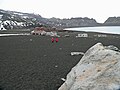
In 1948 Argentina opened its Base Decepción research station, which was manned all year round until the volcanic eruption in 1967 and is now only operated as a summer station.
In 1989/90 Spain opened the Gabriel de Castilla research station, which is only operated in summer, with a crew of 14 people.
Parts of the island are now restricted area in order to be able to observe the resettlement of plant life on the volcanic ash.
A large breeding colony of chinstrap penguins with an estimated 100,000 breeding pairs can be found on the Baily Head promontory on the outer edge of the island in the southeast .
Deception Island is used by cruise ships and is one of the most visited islands in Antarctica.
cards

Map from 1829
Geographical names

Current map


Picture gallery

Chinstrap Penguins on Deception Island (1962)

Wall of the Caldera (2006)

The Rancho Point with the Sewing Machine Needles (2003)

Wall of the Caldera (2006)

The Cross Hill on the phone Bay (2008)
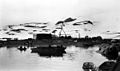
Norwegian whaling station under construction (1912)
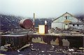
Destroyed British research station
Remains of the British Station (2007)

Former cemetery (1962, meanwhile buried)
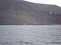
Argentine summer station Base Decepción (2009)
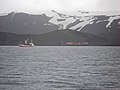
Spanish summer station Gabriel de Castilla (2009)


literature
- Christian Walther: Antarctica. A travel, reading and information book about the continent at the South Pole . 3rd, revised edition. Conrad Stein Verlag, Welver 2004, ISBN 3-89392-280-6 .
- David McGonigal, Lynn Woodworth: The World of Antarctica and the Arctic . 2nd Edition. Delius Klasing Verlag, Bielefeld 2004, ISBN 3-7688-1483-1 .
Web links
- Deception Island. Official website of the island administration. Deception Island Management Group(English).
- Deception island (AQ). Collection of photos of the island. In: imagea.org. imageafoundation(English).
- Deception Iceland in the Global Volcanism Program of the Smithsonian Institution (English)
- Antarctica 2 - The Deception Island Caldera. Blog with photos, graphics and other web links. In: volcanohotspot.wordpress.com. August 31, 2017(English).
Individual evidence
- ^ A b John L. Smellie: Lithostratigraphy and volcanic evolution of Deception Island, South Shetland Islands . In: Antarctic Science . tape 13 , no. 2 , June 2001, ISSN 0954-1020 , p. 188-209 , doi : 10.1017 / S0954102001000281 (English).
- ^ Deception Island - Volcanic Activity. In: deceptionisland.aq. Deception Island Management Group, accessed December 1, 2018 .
- ^ History of Deception Island (Station B). In: British Antarctic Survey . Natural Environment Research Council , accessed December 1, 2018 .
- ^ Deception Island - History. In: deceptionisland.aq. Deception Island Management Group, accessed December 1, 2018 .
- ^ William James Mills: Exploring Polar Frontiers - A Historical Encyclopedia . tape 2 . ABC-CLIO, 2003, ISBN 1-57607-422-6 , pp. 711 .
- ↑ Hans Gerd Eßer: Silent War at the South Pole. In: Köhlers Flottenkalender 1957. Pages 18-20, 22
- ^ Deception Island Management Package . 2005, Appendix 3: Conservation Strategy for Historic Site and Monument No. 71, Whalers Bay, Deception Island, p. 37–43 (English, deceptionisland.aq [PDF; 3.1 MB ; accessed on December 1, 2018]).
- ^ FIDS, Deception Island, Port Lockroy, Fossil Bluff, Bases A, B, KG: Deception Island - Base B. In: Cool Antarctica. Archived from the original on July 28, 2012 ; accessed on December 1, 2018 (English).
- ↑ Deception Island - Flora and Fauna. In: deceptionisland.aq. Deception Island Management Group, accessed December 1, 2018 .
- ^ Deception Island - Current Activities. In: deceptionisland.aq. Deception Island Management Group, accessed December 1, 2018 .