Discovery Bay (South Shetland Islands)
| Discovery Bay | ||
|---|---|---|
|
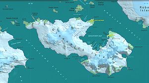
Map of Greenwich Island with Discovery Bay |
||
| Waters | English Strait | |
| Land mass | Greenwich Island , South Shetland Islands | |
| Geographical location | 62 ° 28 '59 " S , 59 ° 42' 58" W | |
|
|
||
| Islands | Basso Island , Bonert Rock , Canales Island , Islotes Catalán , Coloma Island , Cruz Rock , Dovizio Rock , Fuente Rock , Honores Rock , Joliette Rock , Skarmeta Rocks , Tenorio Rock , Valdebenito Rock , Vidal Rock | |
| Tributaries | Fuerza Aérea Glacier , Jorquera Glacier , Traub Glacier | |
The Discovery Bay (loosely translated: Discovery Bay ) is a bay of 5 km long and 3 km wide on the east coast of Greenwich Iceland in the archipelago of the South Shetland Islands .
The bay has been known to seal hunters since at least 1821. Participants in the British Discovery Investigations mapped and named it in 1935.
Web links
- Discovery Bay in the Geographic Names Information System of the United States Geological Survey (English)
- Discovery Bay on geographic.org

