
Punta Arenas
| Punta Arenas | |||
|---|---|---|---|
 |
|||
 |
|||
| Communal data | |||
| region | Región de Magallanes y de la Antártica Chilena | ||
| province | Magallanes | ||
| founding | December 18, 1848 | ||
| Residents | 126,604 (2019) | ||
| surface | 17,846.3 km² | ||
| Population density | 7 people / km² | ||
| Post Code | 6200000 | ||
| prefix | + (56-) 61 | ||
| Time zone | UTC −4 | ||
| Alkalis | Emilio Boccazzi Campos | ||
| Website | |||
| main place | |||
Punta Arenas on the map of Chile |
|||
| Surname | Punta Arenas | ||
| status | Ciudad | ||
| Residents | 116.005 (2002) | ||
| surface | 39.03 km² | ||
| Population density | 2,972 inhabitants / km² | ||

Punta Arenas is a city in the extreme south of Chile .
It is the capital of the Chilean region XII Región de Magallanes y de la Antártica Chilena . It is located on the Chilean mainland opposite the island of Tierra del Fuego and with 125,932 inhabitants (as of 2017) is the largest city in Chilean southern Patagonia .
geography

The city center of Punta Arenas is located in the extreme south of the country on the Strait of Magellan and on the east coast of the Brunswick Peninsula . It fights with other cities for the honor of being the southernmost city in the world , but at least it can be called the southernmost city in the world. The urban area not only includes the entire Brunswick Peninsula, but also numerous mostly uninhabited islands, the largest of them from west to east:
- Isla Santa Inés (uninhabited)
- Isla Clarence (uninhabited)
- Isla Capitán Aracena (uninhabited)
- Isla Dawson (301 inhabitants 2002).
Further north are Puerto Natales and Río Gallegos ( Argentina ), further south are Ushuaia (Argentina) and Puerto Williams .
climate
Punta Arenas belongs to the temperate zone , but due to the influences of the Furious Fifties it is strongly subpolar. The temperature fluctuations are rather small. The mean annual temperature fluctuates around 6 ° C, the precipitation is spread over the whole year, with about 25–45 mm falling in the month. The coldest temperature in the city to date was measured on June 25, 1964 at −16.4 ° C.
| Punta Arenas | ||||||||||||||||||||||||||||||||||||||||||||||||
|---|---|---|---|---|---|---|---|---|---|---|---|---|---|---|---|---|---|---|---|---|---|---|---|---|---|---|---|---|---|---|---|---|---|---|---|---|---|---|---|---|---|---|---|---|---|---|---|---|
| Climate diagram | ||||||||||||||||||||||||||||||||||||||||||||||||
| ||||||||||||||||||||||||||||||||||||||||||||||||
|
Average monthly temperatures and rainfall for Punta Arenas
Source: WMO
|
|||||||||||||||||||||||||||||||||||||||||||||||||||||||||||||||||||||||||||||||||||||||||||||||||||||||||
history
The Chilean colony was established on December 18, 1848 after Puerto del Hambre was destroyed by a military revolt.
The place initially served as a penal colony , later as a free port , which became increasingly important with the discovery of coal (1872) and the introduction of sheep by the English. In 1875 the population was only 915, in 1884 already 4,000 and there were 40,000 sheep, 6,000 cattle and 2,000 horses in 16 estancias .
For many centuries the place was a station on one of the most important trade routes on earth and became wealthy as a result. It had its first big boom during the California gold rush , when it served as a port of call for the clipper ships. After the opening of the Panama Canal , the port lost its importance, but the city's second spirit of optimism came just in time when it became Chile's center for the wool trade.
Attractions

Punta Arenas is a colorful mix of different cultures and people, from the descendants of Portuguese sailors to English sheep farmers. A large proportion of the population is of Croatian descent, and Russian, Jewish, German and Swiss immigrants have helped shape the image of the city. In contrast, the indigenous peoples were almost completely destroyed at the end of the 19th and early 20th centuries. Nowadays, in the middle of the Plaza de Armas ("Arms Square" or central square) of Punta Arenas there is a monument to Ferdinand Magellan , at whose feet two beaten indigenous people crouch. According to legend, if you kiss or touch the big toe of an indigenous man, you return to Punta Arenas.
The Punta Arenas cemetery is worth seeing; the grave inscriptions (which are often not written in Spanish, but in English, German or Croatian) bear witness to the city's history of immigration. The city's residents claim it is "the most beautiful cemetery in South America". There is also a memorial stone for Vice Admiral Graf Spee in the cemetery.
On the beach in front of the city, three historic sailing ships are set aside as breakwater . The best known and best preserved wreck is that of the County of Peebles , the world's first iron sailing ship with four masts, built in 1875.
Since October 1, 2011, the open- air ship museum Museo Nao Victoria has been open to the public with replicas of ships.
Punta Arenas is also a popular starting point for excursions and cruises in one of the most spectacular scenic landscapes in the world, with the fjord landscapes of the region or the Torres del Paine National Park . There are also some penguin colonies that can be visited.
The Museo de Historia de Natural Rio Seco is a special feature. A team of marine biologists and artists is planning to depict all of Patagonia's animal species through their skeletons. The exhibition has now grown to include several hundred exhibits. The main attraction of the natural history museum is the exhibition of a complete whale skeleton.
Town twinning
sons and daughters of the town
- Vladimiro Boric Crnosija (1905–1973), Roman Catholic bishop
- Augusto Olivares (1930–1973), journalist
- Alejandro Goic Karmelic (* 1940), Roman Catholic Bishop of Rancagua
- Mario Galindo (* 1951), football player
- Ramón Díaz Eterovic (* 1956), writer
- Lorenza Böttner (1959–1994), German multidisciplinary artist
- Giovanna Arbunic Castro (* 1964), chess player
- Erwin Feuchtmann Perez (* 1990), handball player
Illustrations

City center
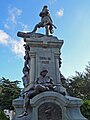
Magellan's Monument in the Plaza de Armas

Strait of Magellan
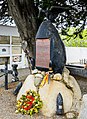
Memorial stone for Vice Admiral Graf Spee in the cemetery

Wall painting in Punta Arenas

Memorial cross "Deutsche Krankenkasse" in the cemetery in Punta Arenas


See also
Web links
Individual references, comments
- ^ Congreso Mundial Croata - Los Croatas de Chile. Retrieved on August 9, 2020 (es-cl).
- ↑ Museo de Historia Natural Río Seco. Retrieved February 7, 2020 .
Coordinates: 53 ° 9 ′ S , 70 ° 55 ′ W