
Puerto Williams
| Puerto Williams | ||
|---|---|---|
|
Coordinates: 54 ° 56 ′ S , 67 ° 37 ′ W Puerto Williams on the map of Chile
|
||
| Basic data | ||
| Country | Chile | |
| province | Antártica Chilena | |
| Comuna | Cabo de Hornos | |
| City foundation | December 30, 1927 | |
| Residents | 2290 (2012) | |
| City insignia | ||
 |
 |
|
| Detailed data | ||
| surface | 1.19 km 2 | |
| Population density | 1,924 inhabitants / km 2 | |
| Waters | Beagle Channel | |
| Post Code | 6350000 | |
| Time zone | UTC −4 | |
| City Presidency | Hugo Henriquez Matus | |
| Website | ||
 |
||

Puerto Williams is a Chilean city on the north coast of the island of Navarino ( Tierra del Fuego archipelago ) on the Beagle Channel with about 2,300 inhabitants.
Puerto Williams is sometimes referred to as the southernmost city in the world. However, this designation is disputed due to the lack of a uniform definition of the term “city”. While Puerto Williams only has about 2300 inhabitants, just a little further north, Argentine Ushuaia, has almost 57,000 people.
Geography and climate
Puerto Williams is the capital of the Antártica Chilena province . This includes the municipalities of Cabo de Hornos (formerly Navarino ) and Antártica , both of which are administered from Puerto Williams. The city is at 54 ° 56 ' S , 67 ° 37' W .
Climate: The highest temperatures are reached in January, with an average of 10.6 ° C (usually it fluctuates around 5 ° C to 15 ° C, but temperatures of 20 ° C can also be reached). July is the coldest month of winter, which is characterized by an average of +2 ° C (−2 ° C to 5 ° C).
Due to the geographical location, the summer is characterized by long days (around 18 hours a day) and the alternation of relatively warm, sunny and rainy days; at night temperatures drop sharply. Winter temperatures usually fluctuate little around zero degrees in a landscape that is usually snow-covered. The days are very short at this time of year (6-hour day).
history
The Isla Navarino area was settled by Anglican missionaries around 1850. Their presence was, however, quite short due to illness and bad weather conditions. Around 1890 the island was the target of a brief gold rush. In this region, Martin Gusinde carried out important ethnographic studies at the beginning of the 20th century . He was a German priest and ethnologist who researched the Yagán people from 1918 to 1923 . Today the local museum is named after him.
Puerto Williams was founded on November 23, 1953 under the name Puerto Luisa and renamed Puerto Williams in 1956. The name was changed in honor of John Williams Wilson , who founded a Fort Fuerte Bulnes near Punta Arenas in 1843 to secure the Chilean territorial claims and to monitor the Strait of Magellan .
In 2002 Puerto Williams got its own small power plant.
tourism
Military and civil areas are roughly in balance today; there is even a burgeoning tourism. From Punta Arenas there is a scheduled flight service with the airline Aerovías DAP to Puerto Williams as well as a ferry connection, ensured by Transbordadora Austral Brooms. Puerto Williams is the starting point for trips to the Chilean Antarctic Territory and is a popular stopover for cruises.

Tourist highlights that can be reached from Puerto Williams include: a. the Trekking routes Rutas Patrimoniales Circuito de los Dientes , Circuito Navarino and Circuito Wulaia , the Martín Gusinde Museum (trilingual: Spanish, English, German), the Cerro la Bandera viewpoint , the Cascada de la Virgen and Cascada Los Bronces waterfalls , the village of Villa Ukkika (This is where the last Yamana Indians live), the Omora Botanical Park , the Yamana Caleta Mejillones cemetery , the former Wulaia and Douglas mission stations , the Iglesia Puerto Williams (southernmost church in the world), the Primera Casa (first house in Pto. Williams ) and the pub Micalvi .
The Circuito de los Dientes is an under- developed hiking trail around the mountain range of the same name southwest of Puerto Williams.
The history of the Yámana natives can be explored in the Martin Gusinde Museum . Aboriginal life can also be followed at Villa Ukika and Caleta Mejillones. The life of the Yagán people can be explored in the Parque Etnobotánico Omora.
The Micalvi pub is housed on a former German Rhine steamer, which also serves as a landing stage for the sailing boats. Sailing tourism plays a not insignificant role for Puerto Williams and has developed particularly in recent years, as has cruise tourism (including MS Nordnorge - Hurtigruten and Mare Australis from Comapa - Cruceros Australis).
Trips to the Cape Horn National Park (630 km²), which was founded in 1945, with its penguin populations are often undertaken. The nearby Cordillera de Darwin with the La Romanche glaciers (the largest in Chile that extends into the water), Holanda , Italia , Francia and Alemania are popular travel destinations.
photos

View from the harbor
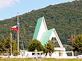
church

signpost

.jpg)

