Navarino (island)
| Isla Navarino | ||
|---|---|---|
| Puerto Williams on Navarino | ||
| Waters | Drake Street | |
| Archipelago | fire land | |
| Geographical location | ||
|
|
||
| length | 88 km | |
| width | 40 km | |
| surface | 2 473 km² | |
| Highest elevation | Pico Navarino 1180 m |
|
| Residents | 2000 <1 inh / km² |
|
| main place | Puerto Williams | |
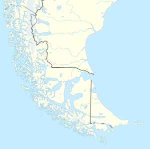
| Map sketch | ||
The island of Navarino ( Spanish Isla Navarino ) is located in the Chilean part of Tierra del Fuego in the Región de Magallanes y de la Antártica Chilena .
geography
The Beagle Channel separates it from Isla Grande Tierra del Fuego with the city of Ushuaia . It has an area of 2,473 km² with a WO extension of about 75 kilometers and a NS extension of about 40 kilometers. In the north of the island is the city of Puerto Williams with around 1,800 inhabitants. Puerto Williams argues with other cities about being the southernmost city in the world .
There are also three small places on the island:
- Puerto Toro to the east
- Caleta Eugenia in the east
- Puerto Navarino to the west
To the east of the island are the three Chilean islands Lennox, Picton and Nueva , which long led to border conflicts with Argentina . 100 kilometers south of the island is Cape Horn and almost 1000 kilometers south of the Antarctic .
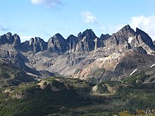
The mountains on the island reach 1,180 m. Many mountains are covered with dense forests of Lenga southern beech (Nothofagus pumilio) and Antarctic false beech (Nothofagus antarctica) .
Since the suspension of beaver on Tierra del Fuego (Tierra del Fuego) in the 1950s, they have also conquered the Navarino Island. Since they have no natural enemies, the population is growing rapidly: Less than 10 animals have been released, and there are now an estimated 120,000. The animals, which have become quite rare in Germany , can still not be observed in the wild without any problems, as they cleverly hide themselves in their numerous dams. Mink that escaped Argentine mink farms have also become pests for the island's sensitive ecosystem. The eggs of breeding birds in particular are used by mink as food.
history
The area of Isla Navarino was settled by Anglican missionaries around 1850, but their presence was short due to diseases and bad weather conditions. Around 1890 the island was the target of a brief gold rush. Father Martín Gusinde (SVD) was an Austrian priest and ethnologist who researched the Yagán people from 1918 to 1923 , today a museum is named after him.
Puerto Williams was founded on November 23, 1953 under the name Puerto Luisa and renamed Puerto Williams in 1956. In honor of Juan Williams Rebolledo , who founded a Fort Fuerte Bulnes near Punta Arenas in 1843 to secure the Chilean territorial claims and to monitor the Strait of Magellan .
In 1977 Argentina declared the Beagle Channel Arbitration between the Republic of Argentina and the Republic of Chile , which awarded all islands south of the Beagle Channel to Chile, null and void and started Operation Soberanía to occupy these islands militarily - especially since in the Area larger oil reserves were suspected. The dispute was only settled through the mediation of the Vatican . Both countries agreed in the friendship and peace treaty of 1984 between Chile and Argentina . The islands remained Chilean territory and the sea border was precisely defined.
tourism
Military and civil sectors are roughly in balance today, and tourism is even burgeoning. From Punta Arenas (Chile) there is a scheduled flight service with the airline Aerovías DAP to Puerto Williams as well as a ferry connection, ensured by Transbordadora Austral Brooms. The island can also be reached by charter plane or boat (Zodiac or sailing ship) from Ushuaia (Argentina). Puerto Williams is the starting point for trips to the Chilean Antarctic Territory .
Tourist highlights that can be reached from Puerto Williams include: a. the trekking routes Rutas Patrimoniales Circuito de los Dientes as well as Circuito Navarino and Circuito Wulaia , the Martín Gusinde Museum (in three languages: Spanish , English, German), the Cerro la Bandera viewpoint , the Cascada de la Virgen waterfalls and Cascada Los Bronces , the village Villa Ukika (this is where the last indigenous inhabitants of the Yámana / Yagan live), the Omora botanical park , the Yámana Caleta Mejillones cemetery , the former mission stations Wulaia and Douglas , Iglesia Puerto Williams (southernmost church in the world), the Primera Casa (first house in Puerto Williams) and the pub Micalvi on a disused historic Rhine ship in the town's marina.
The Circuito de los Dientes is an under- developed hiking trail around the mountain range of the same name southwest of Puerto Williams. Depending on the weather, the mountain hike can take between five and seven days.
In the Martín Gusinde Museum you can explore the history of the Yámana natives. Aspects of indigenous life can also be seen in Villa Ukika and Caleta Mejillones. The use of the plants by the Yagán people can be explored in the Parque Etnobotánico Omora.
The Micalvi pub is housed on a former German Rhine steamer, which also serves as a landing stage for the sailing boats. Sailing tourism plays a not insignificant role for Puerto Williams and has developed, like cruise tourism, especially in recent years.
Trips to the Cape Horn National Park (630 km²), founded in 1945, with its penguin populations are often used. The nearby and attractive Cordillera de Darwin with the glaciers La Romanche (the largest in Chile, which extends into the water), Hollanda , Italia , Franca and Allemania are worth a trip (tip: the ferry "Yahgan" runs once a week during the day when driving from Puerto Williams to Punta Arenas directly past it).


