Beagle Channel
| Beagle Channel | ||
|---|---|---|
| Connects waters | Atlantic Ocean | |
| with water | Pacific Ocean | |
| Separates land mass | Isla Grande de Tierra del Fuego | |
| of land mass |
Isla Navarino , Isla Hoste , Isla Gordon |
|
| Data | ||
| Geographical location | 54 ° 53 ′ S , 68 ° 8 ′ W | |
|
|
||
| length | 240 km | |
| Smallest width | 5 km | |
| Coastal towns | Ushuaia , Puerto Williams | |
| Islands | numerous | |
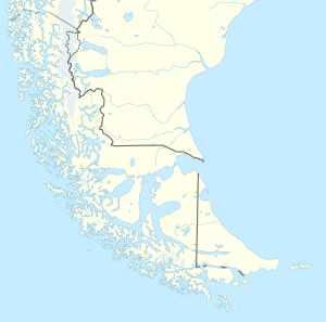
The Beagle Channel is a natural waterway in the south of Tierra del Fuego on the southern tip of South America , which connects the Atlantic with the Pacific . The canal is named after the British research vessel Beagle , with which Robert FitzRoy discovered the waterway in 1831. In addition to the better-known Strait of Magellan , the Beagle Channel in the south of the American continent is the only waterway between the Pacific and Atlantic, as long as the Drake Strait around Cape Horn on the open sea is not included.
In the eastern section of the canal, the border between Argentina and Chile runs in the middle of the waterway that has been just under 2 and up to a maximum of 16 km wide since 1881 . The canal runs between the Isla Grande de Tierra del Fuego in the north and the islands of Navarino , Hoste and Gordon in the south. In the area of the eastern estuary are the larger islands of Lennox, Picton and Nueva , in the western estuary the islands of O'Brien, Londonderry and Steward.
On the northern coastline is Ushuaia , on the opposite bank is the city of Puerto Williams , a Chilean military base that is considered the southernmost city in the world.
The Beagle Channel gave its name to the Beagle conflict between Argentina and Chile, which affected border claims in the region and which escalated into a near war between neighboring countries in the 1980s.
Web links
- Jürgen Vogt: Survival in Tierra del Fuego: Salmon drives away king crab . October 4, 2019 (report).
