Nelson (New Zealand)
|
Nelson Nelson City Māori: Te Kaunihera o Whakatū |
|
| Geographical location | |
| Location of Nelson on the South Island | |
| Photo by Nelson | |
 View over the city center and the harbor |
|
| Local authority | |
| Country | New Zealand |
| island | South island |
| Local authority | Unitary Authority |
| Council | Nelson City Council |
| mayor | Rachel Reese |
| founding | 1841 |
| Post Code | 7010, 7011, 7020 |
| Telephone code | +64 (0) 3 |
| UN / LOCODE | NZ NSN |
| Website | www.nelson.govt.nz |
| presentation | |
  flag and emblem |
|
| geography | |
| Region ISO | NZ-NSN |
| Coordinates | 41 ° 16 ′ S , 173 ° 17 ′ E |
| Highest elevation | 776 m |
| Lowest point | Height of sea level |
| surface | 424 km 2 |
| Residents | 46 437 (2013) |
| Population density | 109.52 inhabitants per km 2 |
| Statistical data | |
| Public revenue | NZ $ 92.3 million (2015) |
| Public expenditure | NZ $ 88.8 million (2015) |
| Number of households | 27 200 (2013) |
| Ø income | NZ $ 27,200 (2013) |
| Māori population | 9.0% (2013) |
Nelson , official name: Nelson City , in Māori Whakatū , is an independent Territorial Authority in the north of the South Island of New Zealand . The city is also a unitary authority , as it simultaneously performs the tasks of a region and the urban area is identical to that of the region.
geography
Geographical location
Nelson City is located in the north of the South Island on Tasman Bay , around 125 km west of Wellington . The bay forms the north-western border of the urban area. The Tasman District joins in the southwest of the city and the Marlborough District in the southeast and east . The city has a pure land area of 424 km² and had a population density of 109.4 inhabitants per km² at the census in 2013 with 46,437 inhabitants.
Nelson City is often referred to as the geographic center of New Zealand. This should be on the 147 m high Botanical Hill in the center of the city. However, this center point was only the center point for performing early land surveys. The true geographic center is actually near Tapawera , some 40 kilometers southwest of Nelson .
To the southeast of the city rise the 1200 m high Bryant Range with the Mount Richmond Forest Park .
City structure
Nelson City is roughly divided into the districts of Stoke , Monaco , Wakatu , Annesbrook , Bishopdale , Tahunanui , Moana , Nelson South , Washington Walley , Port Nelson , Nelson West and Brooklands (from southwest to northeast).
climate
Nelson City is in the zone of prevailing southwest winds. Protected by mountain landscapes to the west that extend south from the Tasman Mountains , rainfall in the Nelson region is between 1000 and 1250 mm per year. With a sunshine duration of 2350 to 2400 hours per year, the average daytime temperatures in summer are between 20 ° C and 22 ° C and in winter a mild 3 ° C to 4 ° C. Nelson is one of the sunniest areas in New Zealand.
history
The area in which the city of Nelson is located today was settled by Māori around 1300 and called Whakatū .
A first contact with Europeans had the inhabitants of New Zealand, around 70 km further north in the Golden Bay , 1642 by the discoverer of New Zealand, Abel Tasman , Murderers' Bay named after four of his crew -members in a dispute of Māori were killed.
In October 1841, Arthur Wakefield , agent of the New Zealand Company , decided to establish a second settlement after Wellington in the area of what is now Nelsons . Land purchases were made hastily, as the first ship with settlers reached the coast in February 1842. More ships were to come in quick succession and within a few months the settlement had several thousand residents.
The land purchases were made through dubious contracts with the local Māori tribe of the Ngāti Toa and subsequently developed a potential for conflict, which erupted on June 17, 1843 in the armed conflict in the Wairau . When Te Rauparaha , the leader of the Ngāti Toa , resisted his arrest and expropriation, fighting broke out in the course of which 22 settlers and four Māori were killed, including Arthur Wakefield , the founder of Nelson . Now leaderless, the New Zealand Company in financial straits and the settlers in Nelson s short on food, in 1843 Frederick Tuckett (co-founder of Nelson ) agreed to take over the management of the settlement as representative of the New Zealand Company . Under his leadership and through the arrival of the Sankt Pauli with German settlers who founded several settlements in the area, such as Sarau , the financial bankruptcy could be averted for the time being.
On March 30, 1874 Nelson was upgraded to a borough with a settlement area of 2761 acres and expanded again in December 1878 to a total of 4800 acres . In the course of the administrative reform of 1989, the Nelson-Marborough Regional Council was dissolved, the Kaikoura District assigned to the Canterbury region and the Tasman and Marlborough districts and the city of Nelson assigned the tasks of a region for their respective areas.
population
Population development
Of the 46,437 inhabitants of the city in 2013, 4,167 inhabitants were of Māori origin (9.0%). This means that 0.7% of the country's Māori population lived in the city. The median income for the population in 2013 was NZ $ 27,200, compared to NZ $ 28,500 national average.
Origin and languages
When asked about ethnic group membership in the 2013 census, 89.3% said they were European, 9.4% said they had Māori roots, 1.8% came from the islands of the Pacific and 4 , 4% came from Asia (multiple answers were possible). 21.2% of the population said they were born overseas and 2.3% of the population spoke Māori , 18.0% of the Māori .
politics
administration
Nelson City is not divided into wards like other cities or districts in New Zealand . The twelve Councilors who, together with the Mayor, form the City Council , are elected every three years. The city council is called Nelson City Council .
Town twinning
Nelson City has three twinned cities and one partnership with Friendly City status .
Sister Cities :
- Miyazu , Japan , since May 1976
- Huangshi , People's Republic of China , since 1995
- Eureka , California , USA , since 2004
Friendly City :
- Yangjiang , China, since July 2014
economy
media
The city's only daily newspaper is the Nelson Mail .
Infrastructure
traffic
In terms of traffic, Nelson is connected by the New Zealand State Highway 6 , which comes from Picton and connects Nelson with Wellington via the ferry . The city's port is to the north of the city center, while the airport is around 5 km southwest of the city center.
Attractions
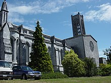
The Anglican Christ Church Cathedral , built in the Art Deco style, with a large flight of stairs , is located in the center of the city. From the start of construction in 1925 to the inauguration in 1972, it took 47 years to build. Near the cathedral is a restored row of houses with workers' quarters from the 19th century.
Nelson is a tourist attraction in the summer months and serves as a starting point for visits to the neighboring national parks. One of the city's attractions is the World of WearableArt gallery, which opened in 2001, with an attached car museum, where the annual award winners exhibit unconventional fashion clothing and classic cars. The two annual Arts Festival and Jazz Festival are another attraction of the city.
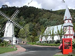
Nelson still owns many wooden houses from the colonial days, which can be recreated in a recreated village in the Founders Historical Park & Brewery with a weekly Farmer's Market .
Personalities
- George Bennett (* 1990), New Zealand cyclist
- Nick Carter (1924–2003), racing cyclist
- Francis Henry Dillon Bell (1851–1936), the country's first Prime Minister to be born in New Zealand
- Rod Dixon (born 1950), middle and long distance runner
- Jordan Dwyer (born 1996), actor
- Karen Holliday (* 1966), racing cyclist
- Denis Hulme (1936–1992), Formula 1 world champion
- Johann Friederich August Kelling (1820–1909), co-founder of the German settlement Ranzau near Nelson , member of the House of Representatives
- Geoffrey Palmer (* 1942), former Prime Minister of New Zealand
- Arthur Lindo Patterson (1902–1966), crystallographer, discovered the Patterson method named after him
- Bill Rowling (1927–1995), politician, former Prime Minister of New Zealand
- Ernest Rutherford (1871–1937), one of the fathers of atomic physics , discoverer of the proton and the first nuclear fission
See also
Web links
- Homepage . Nelson City Council,accessed July 13, 2016.
- Carl Walrond : Nelson places - Nelson city . In: Te Ara - the Encyclopedia of New Zealand . Ministry for Culture & Heritage , accessed July 13, 2016 .
Individual evidence
- ↑ a b c d e 2013 Census QuickStats about a place : Nelson City - Population and dwellings . Statistics New Zealand , accessed July 13, 2016 .
- ↑ a b c d e Nelson City Council . In: Local Councils . Department of Internal Affairs , accessed July 13, 2016 .
- ↑ a b Unitary authority . Nelson City Council , accessed July 13, 2016 .
- ^ A b c Carl Walrond : Nelson places - Nelson city . In: Te Ara - the Encyclopedia of New Zealand . Ministry for Culture & Heritage , April 21, 2015, accessed July 13, 2016 .
- ↑ GR Macara : The Climate and Weather of Nelson and Tasman . In: NIWA Science and Technologies Series . 2nd Edition. Number 71 . National Institute of Water and Atmospheric Research , 2016, ISSN 1173-0382 , p. 13, 15, 22, 27 (English, online PDF 4.8 MB [accessed on July 13, 2016]).
- ^ Carl Walrond : Nelson places - Eastern Golden Bay . In: Te Ara - the Encyclopedia of New Zealand . Ministry for Culture & Heritage , April 21, 2015, accessed July 13, 2016 .
- ^ Carl Walrond : Nelson region - European settlement . In: Te Ara - the Encyclopedia of New Zealand . Ministry for Culture & Heritage , July 13, 2012, accessed July 13, 2016 .
- ^ Carl Walrond : Nelson region - Wairau affray: Arthur Wakefield . In: Te Ara - the Encyclopedia of New Zealand . Ministry for Culture & Heritage , November 16, 2012, accessed July 13, 2016 .
- ^ Nelson Corporation . In: The Cyclopedia of New Zealand . Nelson, Marlborough and Westland Provincial District - Volume V . Cyclopedia Company Ltd , Christchurch 1906 (English, online [accessed February 9, 2017]).
- ↑ 2013 Census QuickStats about a place : Nelson City - Cultural diversity . Statistics New Zealand , accessed July 13, 2016 .
- ^ Contact a Councilor . Nelson City Council , accessed July 13, 2016 .
- ^ Sister and Friendly Cities . Nelson City Council , accessed July 13, 2016 .
- ↑ Topo250 maps . Land Information New Zealand , accessed July 13, 2016 .


