
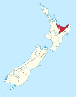
Bay of Plenty (Region)
|
Bay of Plenty Region Māori: Toi Moana |
|
| Geographical location | |
  |
|
| Photo from Bay of Plenty Region | |
.jpg) View from Mount Maunganui on part of Tauranga |
|
| Local authority | |
| Country | New Zealand |
| island | North island |
| Local authority | region |
| Council | Bay of Plenty Regional Council |
| Headquarters of the administration | Whakatāne |
| Telephone code | +64 (0) 7 |
| Website | www.boprc.govt.nz |
| geography | |
| Region ISO | NZ-BOP |
| Coordinates | 37 ° 41 ′ S , 176 ° 10 ′ E |
| Highest elevation | 1475 m |
| surface | 12 071 km 2 |
| Residents | 267 741 (2013) |
| Population density | 22.18 inhabitants per km 2 |
| Statistical data | |
| Public revenue | NZ $ 81.5 million (2015) |
| Public expenditure | NZ $ 85.6 million (2015) |
| Number of households | 117 435 (2013) |
| Ø income | NZ $ 26,200 (2013) |
| Māori population | 25.7% (2013) |
The Bay of Plenty Region is the fifth largest administrative region in the North Island of New Zealand . The council of the region, called the Bay of Plenty Regional Council , has its seat in the city of Whakatāne .
geography
Geographical location
The Bay of Plenty Region covers with 12,071 km² of pure land area the entire part of the coastal region around the Bay of Plenty with its hinterland and the northern part of the land area of the Taupo Volcanic Zone as well as the mountain chains of the Ikawhenua Range , Raungaehe Range and Kahikatea Range , with the highest Elevation, the Maungapohatu with 1366 m . With 267,741 inhabitants counted in 2013, the region has a population density of 22.2 inhabitants per km² and thus represents the region with the fourth highest population density of all 17 regions in the country.
The Bay of Plenty Regional Council counts 18 islands in the sea in its area and 18 nautical miles of sea area in its district. Since the council also counts the inland lakes as part of its land area, this comes to a calculated land area of 12,254 km² and a further 9583 km² of lake area.
By far the largest city in the region is Tauranga with almost 115,000 inhabitants (as of 2013), followed by Te Puke with around 7,000, Whakatāne with around 5000, Opotiki with around 4,200, Katikati with around 3,600 and Waihi Beach with just under 1,800 inhabitants.
climate
The region's climate is subtropical for most of the year. The average summer temperatures are 22 to 26 ° C, but rarely exceed 30 ° C. In winter it hardly gets colder than 9 ° C, but also not much warmer than 15 ° C.
population
Population development
Of the 267,741 inhabitants of the region in 2013, 68,943 were of Māori origin (25.7%). This means that 11.5% of the country's Māori population lived in the Bay of Plenty region . The median income in the population in 2013 was NZ $ 26,200, compared to NZ $ 28,500 national average.
Origin and languages
When asked about ethnic group membership in the 2013 census, 75.7% said they were European, 27.5% said they had Māori roots, 3.1% came from the islands of the Pacific and 5.2 % came from Asia (multiple answers were possible). 17.3% of the population said they were born overseas, and 8.5% of the population spoke Māori , compared to 28.6% among the Māori .
politics
administration
The Bay of Plenty Region has a board of directors called the Regional Council , which is led by a chairman . The Council has fourteen elected councilors representing seven constituencies , Tauranga with five councilors , Eastern Bay of Plenty , Rotorua and Western Bay of Plenty with two each, and Kōhi , Mauāo and Ōkurei each with one councilor . The council members, who choose the chairman from their ranks, are re-elected every three years.
Furthermore, the region is divided into six districts and an independent city:
- Rotorua Lakes (partially, approx. 60%)
- Taupo District (partially, approx. 15%)
While the regional administration is responsible for the inland and coastal waters, for the ports, for land, air, erosion, disaster control, transport planning and regional development, the administrations of the districts are responsible for all other concerns of the citizens and the matters which are in a Local authority must be regulated.
economy
The most important branches of the economy are agriculture and horticulture. In addition to numerous fruits that are grown in the region, the cultivation of the kiwi is of great importance. Milk production, forestry and sheep breeding are also important. In some coastal regions, tourism, which is becoming more and more important, is one of the most important sources of income.
Infrastructure
traffic
The Bay of Plenty region is accessible by the New Zealand State Highway 2, which partly runs parallel to the coast in the coastal region . There are also State Highways 29 , 30 , 33 to 36 and State Highway 38 .
Through the region also leads East Coast Main Trunk , the Auckland and Hamilton to Tauranga and different places situated on the coast, as well as the Kawerau District connects.

Web links
- Homepage . Bay of Plenty Regional Council,accessed June 16, 2016.
Individual evidence
- ↑ a b c d e Bay of Plenty Regional Council . In: Local Councils . Department of Internal Affairs , accessed June 16, 2016 .
- ↑ a b c d 2013 Census QuickStats about a place : Bay of Plenty Region - Population and dwellings . Statistics New Zealand , accessed June 16, 2016 .
- ↑ a b c Topo250 maps . Land Information New Zealand , accessed June 16, 2016 .
- ↑ Our region . Bay of Plenty Regional Council , accessed March 31, 2018 .
- ↑ 2013 Census QuickStats about a place : Tauranga City - Population and dwellings . Statistics New Zealand , accessed June 16, 2016 .
- ↑ 2013 Census QuickStats about a place : Bay of Plenty Region - Cultural diversity . Statistics New Zealand , accessed June 16, 2016 .
- ↑ Representation Review . Bay of Plenty Regional Council , accessed June 16, 2016 .
- ↑ Glossary . In: Local Councils . Department of Internal Affairs , accessed June 16, 2016 .
North Island : Northland | Auckland * | Waikato | Bay of Plenty | Gisborne * | Hawke's Bay | Taranaki | Manawatu-Wanganui | Wellington
South Island : Tasman * | Marlborough * | Nelson * | West Coast | Canterbury | Otago | Southland
Other islands: Chatham Islands *