
Regions of New Zealand
Eleven regions of New Zealand and six Unitary Authorities together form the top level of New Zealand's sub-national administrative units .
Regional councils
The regions are administered by Regional Councils . In the regions of Gisborne, Marlborough and Tasman, the respective District Council (district council) takes on the tasks of the Regional Council , in the Nelson region the City Council (city council), in Auckland since November 1, 2010 the Auckland Council . These five councils are also referred to as Unitary Authorities (German unitary authorities).
Areas outside the regions
The outer areas of New Zealand are not subject to the division into regions. With the Chatham Island Council, there is an institution on the Chatham Islands with competencies comparable to the Unitary Authorities . The Chatham Island Territory is therefore also listed as the 17th region. The Kermadec Islands , Antipodes Islands , Auckland Islands , Bounty Island , Campbell Island and Snare Islands are uninhabited, and the Minister takes on the functions of the Council for the Department of Conservation employees who are there . The Three Kings Islands are also uninhabited.
Tokelau is not part of the national territory of New Zealand, but its colony. Niue and the Cook Islands are autonomous states in free association with New Zealand. New Zealand also makes claims to the Ross subsidiary area , but these are suspended due to the Antarctic Treaty .
Overview of the regions
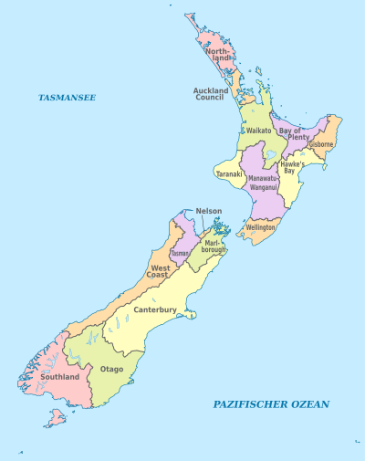
| region | administration | Administrative headquarters | Area in km² |
Residents | Density Ew./km² |
|---|---|---|---|---|---|
| Northland | Northland Regional Council | Whangarei | 12,498 | 151,689 | 12.1 |
| Auckland | Auckland Council | Auckland | 4,938 | 1,415,550 | 286.7 |
| Waikato | Waikato Regional Council | Hamilton | 23,902 | 403,638 | 16.9 |
| Bay of Plenty | Bay of Plenty Regional Council | Whakatāne | 12,071 | 267,741 | 22.2 |
| Taranaki | Taranaki Regional Council | Stratford | 7,254 | 109,608 | 15.1 |
| Gisborne | Gisborne District Council | Gisborne | 8386 | 43,653 | 5.2 |
| Hawke's Bay | Hawke's Bay Regional Council | Napier | 14,164 | 151.179 | 10.7 |
| Manawatu-Wanganui | Horizons Regional Council | Palmerston North | 22,220 | 222,669 | 10.0 |
| Wellington | Wellington Regional Council | Wellington | 8,049 | 471.315 | 58.6 |
| Tasman | Tasman District Council | Richmond | 9,616 | 47,154 | 4.9 |
| Nelson | Nelson City Council | Nelson | 424 | 46,437 | 109.5 |
| Marlborough | Marlborough District Council | Blenheim | 10,458 | 43,416 | 4.2 |
| West coast | West Coast Regional Council | Greymouth | 23,244 | 32,148 | 1.4 |
| Canterbury | Environment Canterbury | Christchurch | 44,508 | 539.433 | 12.1 |
| Otago | Otago Regional Council | Dunedin | 31.209 | 202.470 | 6.5 |
| Southland | Southland Regional Council | Invercargill | 31,195 | 93,339 | 3.0 |
| Chatham Islands | Chatham Islands Council | Waitangi | 794 | 600 | 0.8 |
| New Zealand | Wellington | 264.903 | 4,242,039 | 16.0 |
Source: Department of Internal Affairs (land areas without water as of 2014, population as of 2013 census)
See also
literature
- Jan Kelly, Brian Marshall : Atlas of New Zealand Boundaries . Auckland University Press , Auckland 1996, ISBN 1-86940-149-2 (English).
Web links
- Homepage . In: Local Councils . Department of Internal Affairs,accessed June 8, 2016.
- Homepage . In: New Zealand's Local Government . Local Government New Zealand,accessed June 8, 2016(Association ofLocal Governments).
Individual evidence
- ↑ Unitary Authorities . Environment Foundation , accessed April 27, 2017 .
- ^ Council Profiles by Region . In: Local Councils . Department of Internal Affairs , accessed June 8, 2016 .
North Island : Northland | Auckland * | Waikato | Bay of Plenty | Gisborne * | Hawke's Bay | Taranaki | Manawatu-Wanganui | Wellington
South Island : Tasman * | Marlborough * | Nelson * | West Coast | Canterbury | Otago | Southland
Other islands: Chatham Islands *