Antipodal Islands
| Antipodal Islands | ||
|---|---|---|
| The Antipode Islands seen from the north: the main island in the center, Bollons Island to the left | ||
| Waters | South pacific | |
| Geographical location | 49 ° 41 ′ S , 178 ° 47 ′ E | |
|
|
||
| Number of islands | 6 (+ numerous rocks) | |
| Main island | Antipodes Island | |
| Total land area | 22 km² | |
| Residents | uninhabited | |
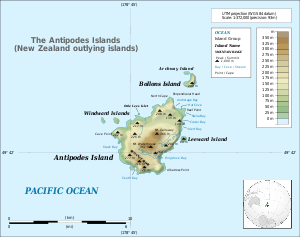
| Topographic map | ||
The Antipodes Islands ( English: Antipodes Islands Group or Isle Penantipode ) are a group of uninhabited rock islands of volcanic origin in the South Pacific . Politically, they belong to New Zealand and are counted among the New Zealand Offshore Islands . Geographically, they are one of the sub-Antarctic islands and are located about 650 km southeast of New Zealand's Stewart Island . The highest point is Mount Galloway with 366 m.
Geography and geology
The archipelago consists of the main island of the same name Antipodes Island (about 20 km²), Bollons Island (about 2 km²) to the north with the offshore island Remarkable Arch , two Windward Islands to the west, a Leeward Island to the east, a southern part of the southwest and several small cliffs . The mean annual temperature is 8 ° C and the annual rainfall is 1000 to 1500 mm.
The islands are predominantly made up of volcanic rocks that cover the surface in the form of lavas that have flowed out. According to Patrick Marshall's description, the rocks are basalts with a porphyry texture and volcanic glasses .
history
Discovery and naming
The islands were discovered on March 26, 1800 by Henry Waterhouse , captain of the HMS Reliance , and were initially called the Penantipodes . The islands owe their name to the fact that they are almost in an antipodal position to London. In fact, they are opposite a point in the sea off Cherbourg in Normandy in north-west France ( 49 ° 40 ′ 59 ″ N , 1 ° 13 ′ 0 ″ W ).
Attempts at colonization and economic use
The attempt to raise cattle on the islands failed due to the harsh climate. In 1893, the Spirit of Dawn sank near the main island and the survivors had to stay on the island for 3 months. In 1804 the seal hunt began on the islands, which reached its peak between 1814 and 1815 with 400,000 hunted animals.
Wildlife
Apart from the Bounty Islands, the islands are the only nesting site for crowned penguins (Eudyptes sclateri) , of which around 150,000 pairs breed here. In addition, around 50,000 pairs of rockhopper penguins (Eudyptes chrysocome) breed here .
Endemic the are Antipodes Parakeet (Cyanoramphus unicolor) , the antipode Ziegensittich (Cyanoramphus novaezelandiae hochstetteri) , the antipodes island Schnepfe (Coenocorypha aucklandica meinertzhagenae) , and the antipodes island Pieper (Anthus novaeseelandiae steindachneri) , a Spornpieperart . In addition, the rare wandering antipodal albatross (Diomedea exulans antipodensis) breeds on the islands. The southern elephant seal (Mirounga leonina) can also be found on the archipelago.
See also
natural reserve
The islands have been part of the UNESCO World Heritage Site since 1998 . To preserve the unique flora and fauna, the New Zealand government has banned entry to the islands.
Web links
Individual evidence
- ^ P. Marshall: New Zealand and adjacent islands (Handbook of Regional Geology, VII. Vol. Dept. 1), Heidelberg 1911, p. 62


