Mount Galloway
| Mount Galloway | ||
|---|---|---|
| height | 366 m | |
| location | Antipode Islands , New Zealand | |
| Coordinates | 49 ° 41 '4 " S , 178 ° 46' 52" O | |
|
|
||
| particularities | Highest mountain in the Antipode Islands | |
|
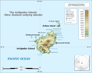
Topographic map of the Antipode Islands |
||
Mount Galloway is the highest mountain of the New Zealand Antipode Islands in the South Pacific , about 770 km southeast of the South Island of New Zealand. It is located in the center of Antipodes Island , the main island of the archipelago and reaches a height of 366 m, according to other sources also 402 m above sea level. Mount Galloway provides the highest elevation of a volcano of type Pyroclastic cone from the Holozän represents.
Web links
- Mount Galloway on Peakbagger.com (English)
Individual evidence
- ↑ Detailed topographic map of Land Information New Zealand (JPG)
- ↑ a b Mount Galloway in the Global Volcanism Program of the Smithsonian Institution (English)

