
Gisborne District
|
Gisborne District Māori: Te Kaunihera o Te Tairāwhiti |
|
| Geographical location | |
  |
|
| Photo from Gisborne District | |
 Tolaga Bay with Uawa River and mountains in the background |
|
| Local authority | |
| Country | New Zealand |
| island | North island |
| Local authority | Unitary Authority |
| Council | Gisborne District Council |
| Headquarters of the administration | Gisborne |
| mayor | Meng Foon |
| Telephone code | +64 (0) 6 |
| Website | www.gdc.govt.nz |
| geography | |
| Region ISO | NZ GIS |
| Coordinates | 38 ° 40 ′ S , 178 ° 1 ′ E |
| Highest elevation | 1754 m |
| surface | 8th 386 km 2 |
| Residents | 43 653 (2013) |
| Population density | 5.21 inhabitants per km 2 |
| Statistical data | |
| Public revenue | NZ $ 75.8 million (2015) |
| Public expenditure | NZ $ 81.5 million (2015) |
| Number of households | 18th 063 (2013) |
| Ø income | NZ $ 24,500 (2013) |
| Māori population | 45.1% (2013) |
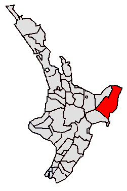
The Gisborne District is an administrative unit on the North Island of New Zealand . The district council, called Gisborne District Council , has its seat in the city of Gisborne . The district has the status of a unitary authority , since it performs the administrative tasks of a region at the same time with its administration, whereby the boundaries of the region are congruent with those of the district.
geography
Geographical location
With 8386 km² of pure land area, the district is the largest of all districts on the North Island of New Zealand. With 43,653 inhabitants counted in 2013, the district has a population density of 5.2 inhabitants per km² and is thus one of the districts with the lowest population density.
The Gisborne District is located in the northeast of the North Island. It is bordered to the west by the Opotiki District and, on a small section inland, by the Whakatāne District . Both belong to the Bay of Plenty region . In the southwest and south, this is done by the Wairoa District , which is part of the Hawke's Bay region. The northern and eastern borders of the district are formed by the Pacific Ocean .
The landscape of the district is determined by a mountain landscape below 1000 m with extensive forests. Only the mountain chain of the Raukumara Range in the northwest has higher altitudes. Here you can also find the highest mountain in the district, the 1754 m high Hikurangi .
The only big city in the district is Gisborne with around 32,700 inhabitants. All other places are each below 1000 inhabitants.
climate
The district's climate can be viewed as subtropical, warm and humid in summer and mild in winter. The south-westerly winds bringing cooler air through the mountains have no effect on the coastal region. The daytime temperatures in summer are above 24 ° C on 65 days, with around 2200 hours of sunshine per year. Precipitation ranges from around 1000 mm in the coastal regions to over 2500 mm in the various mountain regions.
history
The region around Gisborne was first known when the British explorer and navigator James Cook landed in Poverty Bay in 1769 and gave it the name that is still valid today. Around 1450, the Māori region is said to have arrived and settled.
The district in its current form was formed during the 1989 administrative reform and was the result of the amalgamation of Gisborne City Council , Cook County Council , Waiapu County Council , Waikohu County Council , Gisborne Harbor Board , East Cape Catchment Board and the East Coast Pest Destruction Board .
population
Population development
In 2013, 19,683 of the 43,653 inhabitants of the district were of Māori origin (45.1%). This means that 3.3% of the country's Māori population lived in the Gisborne District . The median income for the population in 2013 was NZ $ 24,500, compared to NZ $ 28,500 national average.
Origin and languages
When asked about ethnic group membership in the 2013 census, 60.8% said they were European, 48.9% said they had Māori roots, 3.8% came from the islands of the Pacific and 2.7% % came from Asia (multiple answers were possible). 9.7% of the population said they were born overseas and 15.6% of the population spoke Māori , 30.4% among the Māori .
politics
administration
The Gisborne District is in turn divided into five wards , the Gisborne Ward with eight Councilors (council members) and the Taruheru-Patutahi Ward , the Waipaoa Ward , the Tawhiti-Uawa Ward and the Matakaoa-Waiapu Ward with one Councilor each . Together with the Mayor (mayor) they form the District Council (district council). The mayor and the thirteen councilors are re-elected every three years.
Twin cities
- Palm Desert , California , USA , since April 23, 1981
- Nonoichi-machi , Ishikawa Prefecture , Japan , since March 30, 1990
- Rizhao , Shandong Province , China , since August 3, 1996
- Mahina , Tahiti , French Polynesia , since 2006
- Gamagōri , Aichi Prefecture , Japan , since 1996
economy
Agriculture, viticulture and the manufacturing industry are important branches of the economy in the district, with the former being found in the rural regions and mechanical engineering and other technical operations in the city of Gisborne and the periphery. The fastest growing areas of the economy between 2012 and 2014 were the veterinary sector with a growth rate of 45.3%, followed by the wine industry with 20.2%, mechanical engineering with 17.7%, and print & media with 14 .7% and technical-scientific service with 12.4%.
One of the largest companies in the district is the Eastland Group , which also operates the electricity grid, a geothermal power plant, the port and the airport of Gisborne .
Infrastructure
traffic
Road traffic
The Gisborne District is connected by the New Zealand State Highway 2 , which, coming from the northwest, connects Gisborne with the city of Opotiki on one side and to the south with Napier . The State Highway 35 leads the entire district along the coast and connects Gisborne again with Opotiki on a long detour.
Air traffic
The airport ( IATA code: GIS) is located on the western outskirts of Gisborne. As a regional airport, it serves the most important cities in New Zealand. In addition to an asphalt runway, it has two additional grass runways. A special feature of this airport is that its runway is crossed by a railway line. In addition to Air New Zealand, planes from Sunair Aviation Ltd. also fly . different airports in the country.
See also
literature
- Gisborne District Council (Ed.): Local Governance Statement . April 2014, ISSN 1176-5127 (English, Online PDF 1.2 MB [accessed June 20, 2016]).
Web links
- Homepage . Gisborne District,accessed June 20, 2016.
Individual evidence
- ↑ a b c d e f Gisborne District . In: Local Councils . Department of Internal Affairs , accessed June 20, 2016 .
- ↑ a b c d 2013 Census QuickStats about a place : Gisborne District - Population and dwellings . Statistics New Zealand , accessed June 20, 2016 .
- ↑ a b Topo250 maps . Land Information New Zealand , accessed June 20, 2016 .
- ^ Gisborne District Council (Ed.): Local Governance Statement . 2014, p. 1 .
- ^ Gisborne District Council (Ed.): Local Governance Statement . 2014, p. 2 .
- ↑ 2013 Census QuickStats about a place : Gisborne District - Cultural diversity . Statistics New Zealand , accessed June 20, 2016 .
- ^ Gisborne District Council (Ed.): Local Governance Statement . 2014, p. 1, 12 .
- ^ Sister Cities . Gisborne District Council , April 15, 2015, accessed June 20, 2016 .
- ↑ Our Region . In: Activate Tairāwhiti . Gisborne District Council , accessed April 12, 2018 .
- ↑ Homepage . Eastland Group , accessed June 20, 2016 .
- ^ Kaushik : Strange Airport # 5: Gisborne Airport - Runway With a Railway Crossing . Blog: Amusing Planet , August 11, 2013, accessed June 20, 2016 .
- ^ A Little History About Sunair . Sunair Aviation Ltd. , archived from the original on June 20, 2016 ; accessed on April 12, 2018 (English, original website no longer available).
Northland :
Far North District •
Kaipara District •
Whangarei District
Auckland Council (Unitary Authority)
Waikato :
Thames-Coromandel District •
Hauraki District •
Waikato District •
Matamata-Piako District •
Hamilton City •
Waipa District •
Otorohanga District •
Rotorua Lakes 40% •
Waitomo District 95% •
Taupo District 75%
Bay of Plenty :
Western Bay of Plenty District •
Tauranga City •
Opotiki District •
Whakatāne District •
Rotorua Lakes 60% •
Kawerau District •
Taupo District 10%
Gisborne District (Unitary Authority)
Hawke's Bay :
Wairoa District •
Taupo District 10% •
Hastings District •
Napier City •
Central Hawke's Bay District •
Rangitikei District 10%
Taranaki :
New Plymouth District •
Stratford District 70% •
South Taranaki District
Manawatu-Wanganui :
Taupo District 5% •
Waitomo District 5% •
Ruapehu District •
Stratford District 30% •
Rangitikei District 90% •
Whanganui District •
Manawatu District •
Palmerston North City •
Tararua District 97% •
Horowhenua D istrict
Wellington :
Tararua District 3% •
Masterton District •
Kapiti Coast District •
Carterton District •
South Wairarapa District •
Upper Hutt City •
Porirua City •
Hutt City •
Wellington City
Tasman District ( Unitary Authority )
Nelson City ( Unitary Authority )
Marlborough District ( Unitary Authority )
West Coast :
Buller District •
Gray District •
Westland District
Canterbury :
Kaikoura District •
Hurunui District •
Selwyn District •
Waimakariri District •
Christchurch City •
Ashburton District •
Mackenzie District •
Timaru District •
Waitaki District 55% •
Waimate District
Otago :
Queenstown-Lakes District •
Central Otago District •
Waitaki District 45% •
Dunedin City •
Clutha District
Southland :
Southland District •
Gore District 70% •
Invercargill City