Tasman District
| Tasman District | |
| Geographical location | |
| Location of the Tasman District | |
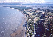
| Photo from Tasman District | |
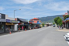
 Richmond Main Street |
|
| Local authority | |
| Country | New Zealand |
| island | South island |
| Local authority | Unitary Authority |
| Council | Tasman District Council |
| Headquarters of the administration | Richmond (New Zealand) |
| mayor | Richard Kempthorne |
| founding | July 1992 |
| Post Code | 7020, 7072, 7073, 7077, 7091, 7095, 7120, 7173-7175, 7181, 7183, 7196-7198, 7275, 7895 |
| Telephone code | +64 (0) 3 |
| Website | www.tasman.govt.nz |
| geography | |
| Region ISO | NZ-TAS |
| Coordinates | 41 ° 20 ′ S , 173 ° 11 ′ E |
| Lowest point | Height of sea level |
| surface | 9 616 km 2 |
| Residents | 47 154 (2013) |
| Population density | 4.9 inhabitants per km 2 |
| Statistical data | |
| Public revenue | NZ $ 94.2 million (2015) |
| Public expenditure | NZ $ 87.9 million (2015) |
| Number of households | 21st 741 (2013) |
| Ø income | NZ $ 25,700 (2013) |
| Māori population | 7.3% (2013) |

The Tasman District is an administrative unit on the South Island of New Zealand . The district council, called Tasman District Council , has its seat in the city of Richmond . The district has the status of a unitary authority , since it performs the administrative tasks of a region at the same time with its administration, whereby the boundaries of the region are congruent with those of the district.
geography
Geographical location
The Tasman District is located in the northwest of the South Island on the Tasman Sea . To the north, the Tasman Sea, Golden Bay and Tasman Bay form the natural boundaries of the district. The west and south-west is bounded by the Buller District , which is already part of the West Coast region, in the southeastern corner is the Hurunui District , which belongs to the Canterbury region , and the Marlborough District borders to the east . The Tasman District shares a small section to the northeast with the urban area of Nelson . The district has a pure land area of 9,616 km² and had a population density of 4.9 inhabitants per km² at the census in 2013 with 47,154 inhabitants.
Most of the district is characterized by a mountain landscape that reaches heights of over 1800 m . Only the area southwest of Tasman Bay is largely flat and lies in the catchment areas of the Moutere River and Waimea River . The largest city in the district is Richmond with just under 12,300 inhabitants, followed by Motueka with around 7600, Mapua with around 2000, Wakefield with around 2100, Brightwater with a good 1750 and Takaka with just under 1250 inhabitants. The district is connected by the New Zealand State Highway 6 , which crosses the district in a south-westerly direction when coming from Nelson . Branch off from Richmond , State Highway 60 connects the northern part of the district.
The geographic center of New Zealand is near Tapawera , around 40 km southwest of Nelson .
climate
The Tasman District is influenced by the winds coming from the Tasman Sea. While in the mountain landscapes of the Tasman Mountains the precipitation is above 3500 mm per year, it is reduced on the lee side of the mountains to 1000 mm per year depending on the location. The coastal regions and the plains are drier, the mountain regions generally more humid. The average daytime temperatures in summer are between 16 ° C and 24 ° C depending on the altitude; the winters, however, are cold in the mountains with frequent sub-zero temperatures, on the coasts mild with temperatures between 3 ° C and 7 ° C, the latter in the north on the coast. The annual sunshine duration in the mountains is between 1700 and 2000 hours depending on the location and on the coasts and in the plains between 2100 and 2400 hours.
history
According to the traditions of the Māori , the first waka (canoe) with the name Uruao reached the area of today's Tasman region as early as the 12th century. Archaeological finds show that the indigenous people of New Zealand explored the whole region, but mainly settled on the coast, where they found plenty of food. Historians conclude from the frequent change of various Iwi (tribes) that this period was marked by violent armed conflicts.
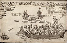
In 1642 the Dutchman Abel Tasman anchored in what is now known as Golden Bay . When attempting to go ashore, the Māori were hostile to him. Four sailors were killed and Tasman, after whom the region was finally named, called the bay "Murderer's Bay" and consequently never set foot on New Zealand soil.
From 1828 an association of numerous Māori tribes from the North Island (including Ngāti Toa ) invaded the South Island and settled the area from Farewell Spit to the Wairau River . Under Arthur Wakefield , agent of the New Zealand Company , the first settlers reached what is now the region in 1842. During the 1850s new settlements were established and agricultural use of the area began , particularly in the Waimea Plains . When gold was discovered near Collingwood in 1856 , the first gold rush in the history of the Pacific state began. Large iron deposits were later discovered near Onekaka on Golden Bay , and these were mined until the 1930s. At the end of the 19th century, fruit-growing began in the sun-drenched region, which, along with tourism, has been one of the most important industries in the Tasman region since the mid-20th century.
In the Tasman District is the village of Upper Moutere , which was founded in the 1850s by the first German immigrants to New Zealand and was called Sarau until 1917 . Traces of German settlement history can still be found there today.
The Tasman District was founded in July 1992 by dividing the Nelson-Marlborough region into the three Unitary Authorities Nelson , Marlbourough and Tasman .
population
Population development
Of the 47,154 inhabitants of the city in 2013, 3438 inhabitants were of Māori origin (7.3%). This means that 0.6% of the country's Māori population lived in the Tasman District . The median income for the population in 2013 was NZ $ 25,700, compared to NZ $ 28,500 national average.
Origin and languages
When asked about ethnic group membership in the 2013 census, 93.1% said they were European, 7.6% said they had Māori roots, 1.1% came from the islands of the Pacific and 1.9% % came from Asia (multiple answers were possible). 17.8% of the population said they were born overseas. 1.9% of the population spoke German as the second most common language after English, and 12.7% of the Māori spoke the Maori language .
politics
administration
The Tasman District is divided into five wards , the Richmond Ward with four Councilors (councilors), the Motueka Ward and the Moutere-Waimea Ward with three each, the Golden Bay Ward with two and the Lakes-Murchison Ward with one Councilor . The thirteen Councilors , together with the Mayor, form the District Council and are elected every three years. A specialty in the district is the Kaumātua (elder). His role is to advise the council on all matters concerning Māori .
Town twinning
The district has three partnerships based on the status of a Friendly Town :
- Grootegast , Netherlands with the district
- Kiyosato , Japan with the small town of Motueka
- Fujimi Machi , Nagano , Japan with the city of Richmond
See also
Web links
- Homepage . Tasman District Council,accessed July 14, 2016.
Individual evidence
- ↑ a b c d e Tasman District Council . In: Local Councils . Department of Internal Affairs , accessed July 14, 2016 .
- ↑ a b c d 2013 Census QuickStats about a place : Tasman District - Population and dwellings . Statistics New Zealand , accessed July 14, 2016 .
- ↑ Topo250 maps . Land Information New Zealand , accessed July 14, 2016 .
- ^ Carl Walrond : Nelson places - Nelson city . In: Te Ara - the Encyclopedia of New Zealand . Ministry for Culture & Heritage , April 21, 2015, accessed July 13, 2016 .
- ↑ GR Macara : The Climate and Weather of Nelson and Tasman . In: NIWA Science and Technologies Series . 2nd Edition. Number 71 . National Institute of Water and Atmospheric Research , 2016, ISSN 1173-0382 , p. 13, 15, 22, 27 (English, online [PDF; 4.6 MB ; accessed on July 14, 2016]).
- ^ A b c History of Tasman District . Tasman District Council , accessed July 14, 2016 .
- ^ A Regional Profile - Tasman . (PDF 774 kB) Statistics New Zealand , accessed on April 26, 2017 (English).
- ↑ 2013 Census QuickStats about a place : Tasman District - Cultural diversity . Statistics New Zealand , accessed July 14, 2016 .
- ↑ a b Mayor & Councilors . Tasman District Council , accessed July 14, 2016 .
- ^ Friendly Towns of Tasman District . Tasman District Council , October 1, 2018, accessed May 18, 2019 .


