Farewell Spit
| Farewell Spit | |
 NASA satellite image of Golden Bay and Farewell Spit |
|
| Geographical location | |
| Coordinates | 40 ° 31 ′ S , 172 ° 52 ′ E |
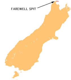
| location | Northwestern tip of the South Island from New Zealand |
| Waters 1 | Golden Bay |
| Waters 2 | Cook Strait , Tasman Sea |
| length | 28 km |
| width | 1.5 km |
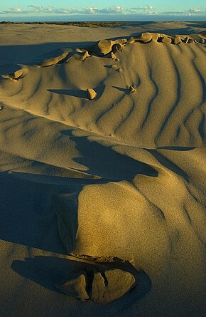
 Sand dunes at Farewell Spit |
|
Farewell Spit (from English spit = "headland"; Maori : Tuhuroa ; Dutch : Sand Duining Hoeck ) is a narrow headland in the far north of New Zealand's South Island . The spit extends from Cape Farewell , the northernmost point of the South Island, to the east.
The Farewell Spit forms the northern boundary of the Golden Bay . The headland runs in an east-west direction over a length of a good 32 kilometers, of which more than 26 above sea level. The land consists primarily of silicon dioxide , although traces of garnet , ilmenite , magnetite and pyroxene can also be found. The spit owes its formation to the extremely strong currents in the Cook Strait . The constant movement piles up the sand in a hook-like shape. Forecasts assume that the headland will gain another two kilometers in length in the next five years alone.
The north side of the headland is steeper and more unstable than the south side, as it is exposed to the constant currents and gusts of wind from the north, which sweep the area at an average speed of over 25 km / h. The side facing the Golden Bay, however, is much more stable and largely covered by vegetation. At low tide , the water on the wind- and current-averted side withdraws up to seven kilometers; this creates an approximately 80 square kilometer mudflat landscape , which is an important food reservoir for numerous different birds, but also represents a deadly trap for whales that are regularly stranded .
The Dutch Abel Tasman was probably the first European to see the headland in 1642, which he called "Sand Duining Hoeck". In 1770 the next navigator, the British captain James Cook , reached the area of the spit. He referred to the southernmost headland of the South Island as Cape Farewell , as the cape was the last area of land Cook saw before returning to England. The name stayed and the first European settlers in the area called the headland "Cape Farewell Spit", but over the years the name was shortened to the "Cape" and the current name was created.
In 1869 the construction of a lighthouse was started at the end of the spit, as many ships were shipwrecked at Farewell Spit. The first lighthouse , a wooden structure, was put into operation on June 17, 1870. However, the wooden construction was not suitable for the location with the frequent sandstorms. In January 1891, a second lighthouse was inaugurated, this time a framework made of steel. This tower is 27 meters high, the fire height is 30 meters. The white light is visible 19 nautical miles (35 kilometers), the red 15 nautical miles (27 kilometers).
The location of the lighthouse was initially without any vegetation and thus without protection against the sandstorms. It was not until the turn of the century that pines were able to be planted as wind protection after potting soil had been brought onto the spit. Around 1960 the lighthouse was connected to the power supply, before oil and diesel generators had been used to generate electricity. In 1984 the last lighthouse keeper left his post when the entire system was automated and, like most of the beacons that still exist today, was remotely controlled from Wellington. The headland is administered by the New Zealand Department of Conservation and serves as a nature reserve for sea birds. With the exception of a small area in the very west of the spit, entering the headland is prohibited. An exception are guided tours, where you can slide down the sand dunes and visit the lighthouse and a gannet colony .
Wharariki Beach
Wharariki Beach begins 5 km west of the beginning of the headland, directly at Cape Farewell. Because of the striking rock formations with caves, cliffs, the offshore rock islands Archway Islands and dunes, the beach is a popular motif with photographers and a location for the film In my Heaven (Lovely Bones) by Peter Jackson .


