Kaipara District
|
Kaipara District Māori: Kaipara te Oranganui |
|
| Geographical location | |
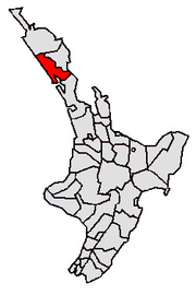
 Location of the Kaipara District |
|
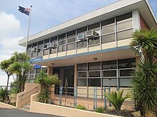
| Photo from Kaipara District | |
 Landscape with a view of the 282 m high former volcano Maungaturoto |
|
| Local authority | |
| Country | New Zealand |
| island | North island |
| region | Northland |
| Local authority | District |
| Council | Kaipara District Council |
| Headquarters of the administration | Dargaville |
| mayor | Greg Gent |
| founding | 1989 |
| Telephone code | +64 (0) 9 |
| Website | www.kaipara.govt.nz |
| presentation | |
| Motto |
Two Oceans Two Harbors ( Two Oceans Two Harbors ) |
| geography | |
| Region ISO | NZ-NTL |
| Coordinates | 35 ° 56 ′ S , 173 ° 52 ′ E |
| Highest elevation | 770 m |
| Lowest point | Height of sea level |
| surface | 3 109 km 2 |
| Residents | 18th 960 (2013) |
| Population density | 6.1 inhabitants per km 2 |
| Statistical data | |
| GDP (Engl. GDP) | NZ $ 0.706 billion (2015) |
| GDP / capita | NZ $ 37,236 per inhabitant |
| Public revenue | 40.6 million NZ $ (2015) |
| Public expenditure | 45.0 million NZ $ (2015) |
| Number of households | 10 962 (2013) |
| Ø income | NZ $ 22,600 (2013) |
| Māori population | 21.6% (2013) |
The Kaipara District is an administrative unit in the Northland region in New Zealand . The district council, called Kaipara District Council ( District Council ), is based in the city of Dargaville , as is the district administration.
geography
Geographical location
The Kaipara District is located south of the Far North District , in the northern part of the North Island . With 3109 km² of pure land area, it represents the second largest district in the Northland region. With 18,960 inhabitants in 2013, the district has a population density of 6.1 inhabitants per km².
The district is bounded to the west by the Tasman Sea , to the north by the Far North District , to the east by the Whangarei District and to the south by the former Rodney District , which was incorporated into the Auckland Council in 2010 .
The western coastal landscape, which appears to be drawn with a ruler, runs from the north in a south-easterly direction and ends at the entrance to Kaipara Harbor . The eastern coastline is only 13 km long and runs almost in a straight line to the north at the height of Mangawhai . The southern border of the district over land is here between Kaipara Harbor and the Pacific Ocean only 24 km long and forms an isthmus on the otherwise 55 km wide part of Northland in this area .
In the area of the district is the Waipoua Forest , one of the largest surviving Kauri forests. These trees originally covered the entire Northland Peninsula but have largely been cut down over the past few centuries. Despite the extensive deforestation, the area is still often on the west coast as Kauri Coast , so Kauri referred -Küste.
By far the largest city in the district is Dargaville with 4251 inhabitants .
climate
The climate in the district is determined by the Tasman Sea and the Pacific Ocean and is known as subtropical . The average temperatures per day are 18 ° C in summer and 10 ° C in winter. Frost hardly ever occurs. The precipitation averages 250 mm in summer and 450 mm in winter, and 1400 mm over the year. The average duration of sunshine is around 1800 hours per year.
history
The Kaipara District is one of the districts in New Zealand where the Polynesian ancestors of the Māori first settled when they came to New Zealand. The tribes of Te Uri o Hau , Te Roroa and smaller ones like Te Kuihi , Te Parawhau , Ngāti Whatua Runanga or parts of the Ngāpuhi and Ngāti Wai are native to the area.
The town of Dargaville is a special feature of the settlement history. In the early 20th century, settlers from Dalmatia came to work in the "rubber plantations" of the Kauri forests around Dargaville and to harvest Kauri resin . Many stayed and settled.
population
Population development
Of the district's 18,960 inhabitants, 4101 were of Māori origin in 2013 (21.6%). More than 3/4 of the population lives in rural and village areas. The median income in the population in 2013 was NZ $ 22,600, compared to NZ $ 28,500 national average.
Origin and languages
When asked about belonging to an ethnic group, 84.2% said they were European in the 2013 census, 23.1% said they had Māori roots, 2.9% came from the islands of the Pacific region and 2.0% came from Asia (multiple answers were possible). 13.0% of the population said they were born overseas and 17.2% of the population spoke Māori , 17.2% of the Māori .
politics
administration
The Kaipara District itself is divided into three wards , the Dargaville Ward , the Otamatea Ward and the West Coast Central Ward, and is politically managed by the Kaipara District Council , which is presided over by a Mayor and eight Councilors . The eight councilors represent the three wards with shared responsibility . The mayor and council members are re-elected every three years.
economy
In 2015, the district had 3450 companies with a total of 7889 employees. By far the largest branch of industry in the district is agriculture and forestry together with fishing at 31.7%, followed by 11.8% in the manufacturing industry and 8.9% in the real estate sector. With its long west coast, the district offers many holidaymakers good opportunities for relaxation. Nevertheless, tourism only accounts for 2.2% of the district's gross national product.
Infrastructure
traffic
The district is connected to traffic by the New Zealand State Highway 1 , which runs from north to south and crosses the district in the southeast. The State Highway 12 , however, passes through the entire district to the south and then heads north to extend into the adjoining district Far North . The State Highway 14 connects the northern half of the district with the city of Whangarei on the east.
Attractions
- The Dargaville Museum shows the remains of a Māori canoe that was found around 1900 in the sand dunes of the coast.
- Also significant is the Kauri Museum in Matakohe , which tells the story of the exploitation of the Kauri forests in the area.
Web links
- Homepage . Kaipara District Council,accessed June 7, 2016.
Individual evidence
- ↑ a b c d e 2013 Census QuickStats about a place: Kaipara District - Population and dwellings . Statistics New Zealand , accessed June 7, 2016 .
- ↑ a b Kaipara District GDP Structure . Infometrics , accessed June 7, 2016 .
- ↑ a b c d e Kaipara District Council . In: Local Councils . Department of Internal Affairs , accessed June 7, 2016 .
- ↑ a b Topo250 maps . Land Information New Zealand , accessed June 7, 2016 .
- ↑ 2013 Census QuickStats about a place: Dargaville - Population and dwellings . Statistics New Zealand , accessed June 7, 2016 .
- ↑ Use of Climate, Soil, and Crop Information for Identifying Potential Land- Use Change in the Hokianga and Western Kaipara Region . (PDF 4.8 kB) In: NIWA Client Report AKL2003 037 . Kaipara District Council , accessed June 7, 2016 .
- ^ Tangata Whenua Strategy . (PDF 128 kB) Kaipara District Council , accessed on June 7, 2016 (English).
- ^ A b Exhibits at Dargaville Museum - Gum Diggers Hall . Dargaville Museum , accessed June 7, 2016 .
- ↑ 2013 Census QuickStats about a place: Kaipara District - Cultural diversity . Statistics New Zealand , accessed June 7, 2016 .
- ↑ Mayor and Councilors . Kaipara District Council , accessed April 18, 2018 .
- ^ Kaipara District Economic Profile . Infometrics , accessed June 7, 2016 .
- ↑ Tourism in Kaipara . Kaipara District Council , accessed June 7, 2016 .
- ↑ Homepage . The Kauri Museum , accessed June 7, 2016 .
